|
[Previous
Page]
CHAPTER V.
MR. RENNIE'S DRAINAGE OF THE LINCOLN AND
CAMBRIDGE FENS.
|
NOTWITHSTANDING
all that had been done for the drainage of the Fens, as described in
the early part of this work, large districts of reclaimable lands in
Lincoln still lay waste and unprofitable. As early as 1789,
Mr. Rennie's attention was drawn to the drowned state of the rich
low-lying lands to the south of Ely. He then recommended the
application of Watt's steam-engine to pump the water out of the
Botteshaw and Soham Fens, which contained about five thousand acres
of what was commonly called "rotten land." But the Fen men
would not have the steam-engine. They were too much prejudiced
in favour of drainage by windmills, as practised in Holland.
It was not until many years after, that his recommendation was
adopted and the steam-engine was employed to pump the water from the
low-lying swamps which could not otherwise be cleared. The
results were so successful, that the same agency became generally
employed for the purpose, not only in England but in Holland itself,
where the forty-five thousand acres of Haarlemer Meer have since
been effectually drained by the application of the steam-engine.
|
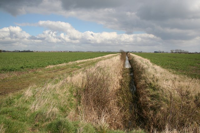
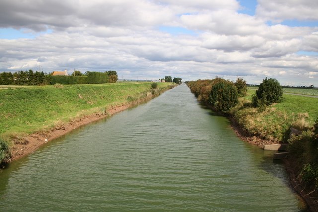
Wildmoor Fen; a classic Lincolnshire fenland view.
© Copyright
Richard Croft and licensed for reuse under this
Creative Commons Licence.
|
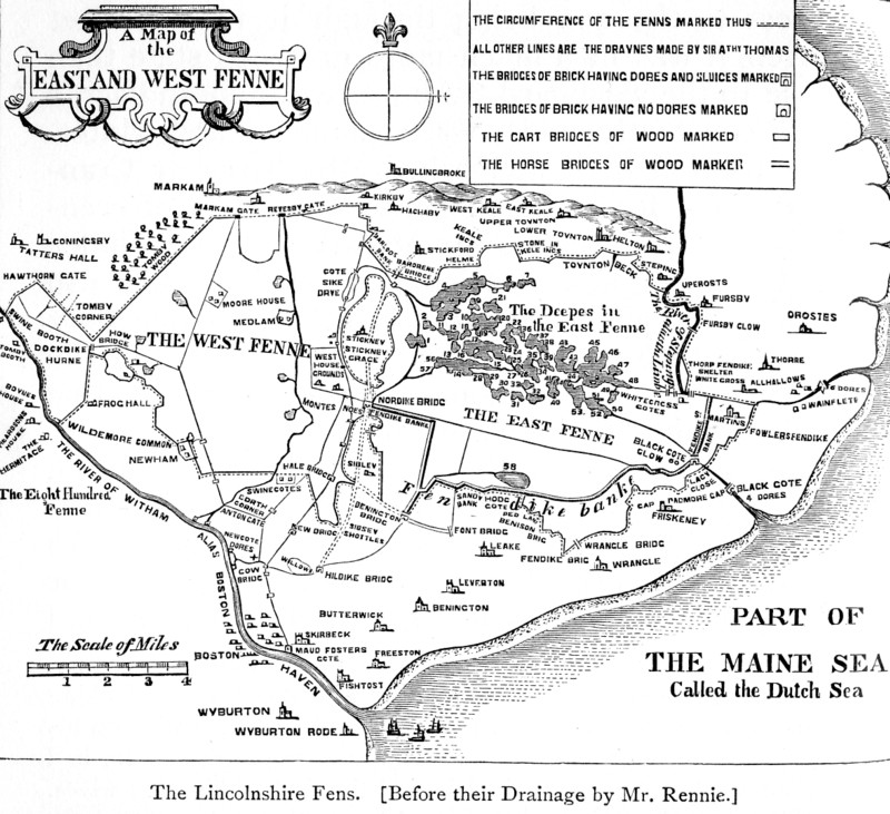
One of the most important works of thorough drainage carried
out by Mr. Rennie, was in that extensive district of South
Lincolnshire which extends along the south verge of the Wolds, from
near the city of Lincoln eastward to the sea. It included
Wildmore Fen, West Fen, and East Fen, and comprised about
seventy-five thousand acres of land which lay under water for the
greater part of each year, and was thus comparatively useless either
for grazing or tillage. The only crop grown in the fens was
tall reeds, which were used as thatch for houses and barns, and even
for churches.
The river Witham, which flows by Lincoln, had been grievously
neglected and allowed to become silted up,—its bottom being in many
places considerably above the level of the land on either side.
Hence, bursting of the banks frequently occurred during floods,
causing extensive inundation of the lower levels,—only a small
proportion of the floodwaters being able to force their way to the
sea.
|

Blankney Fen: Blankney Drove looking northeast.
© Copyright
Ian Carrington and licensed for reuse under this
Creative Commons Licence.
|
The wretched state of the land may be inferred from the fact
that, about seventy years since, a thousand acres in Blankney Fen,
constituting part of "the Dales,"—now one of the most fertile parts
of the district between Lincoln and Tattershall were let annually by
public auction at Horncastle, and the reserved bid was only £10 for
the entire area! [p.285] It
is stated that, about the middle of last century, there were not two
houses in the whole parish of Dogdyke communicable with each other
during the winter, except by boat; this being also the only means by
which the Fen-slodgers could get to church. Hall, the Fen
Poet, speaks of South Kyme, where he was born, as a district in
which, during the winter season, nothing was to be seen—
"But naked flood for miles and miles."
The entire breadth of Lincolnshire north of Boston often lay under
water for months together:—
|
"'Twixt Frith bank and the wold side
bound,
I question one dry inch of ground.
From Lincoln all the way to Bourne,
Had all the tops of banks been one,
I really think they all would not
Have made a twenty acre spot." |
Until as recent a date as forty years back, the rich and fertile
district of Waldersea, about eight thousand acres in extent, was, as
its name imports, a sea in winter. Well might Roger Wildrake
describe his paternal estate of "Squattlesea Mere" as being in the
"moist county of Lincoln!"
Arthur Young visited this district in 1793, and found the
freeholders of the high lands adjoining Wildmore and West Fens
depasturing their sheep on the drier parts during the summer months;
but large numbers of them were dying of the rot. "Nor is
this," he adds, "the only evil; for the number stolen is incredible.
They are taken off by whole flocks, as so wild a country (whole
acres being covered with thistles and nettles four feet high and
more) nurses up a race of people as wild as the fen." The few
wretched inhabitants who contrived to live in the neighbourhood for
the most part sheltered themselves in huts of rushes or lived in
boats. They were constantly liable to be driven out of their
cabins by the waters in winter, if they contrived to survive the
attacks of the ague to which they were perennially subject. [p.287]
The East Fen was the worst of all. It was formerly a
most desolate region, though it now presents probably the richest
grazing land in the kingdom. Being on a lower level than the
West and Wildmore Fens, and the natural course of the waters to the
sea being through it to Wainfleet Haven, it was in a much more
drowned state than those to the westward. About two thousand
acres were constantly under water, summer and winter. One
portion of it was called Mossberry or Cranberry Fen, from the
immense quantities of cranberries it produced. A great part of
the remainder of the East Fen consisted of shaking bog, so
treacherous and so deep in many places that only a desperate
huntsman would venture to follow the fox when he took to it, and
then he must needs be well acquainted with the ground.
Matters were in this state when Sir Joseph Banks, then
President of the Royal Society, endeavoured to stir up the
landowners to undertake the drainage of the district. He was
the proprietor of a good estate at Revesby, near Tattershall; and
his mansion of Abbot's Lodge, standing on an elevated spot,
overlooked the East and West Fens, of which it commanded an
extensive view. Sir Joseph spent a portion of every year at
Revesby, as he did at his other mansions, leaving each at special
times appointed beforehand, almost with the regularity of clockwork.
He was a popular and well-known man, jolly and good-humoured, full
of public spirit, and, though a philosopher, not above taking part
in the sports and festivities of the neighbourhood in which he
resided. While Sir Joseph lived at Revesby he used to keep
almost open house, and a constant succession of visitors came and
went—some on pleasure, some on friendship, and some on business.
The profuse hospitality of the place was enjoyed not less by
the postilions and grooms who drove thither the baronet's guests,
than by the visitors themselves; and it was esteemed by the hotel
postboys a great privilege to drive a customer to Revesby. On
one occasion, when Mr. Rennie went to dine and sleep at the Lodge,
he took an opportunity of saying to the principal butler that he
hoped he would see to his postboy being kept sober, as he wished to
leave before breakfast on the following morning. The butler
replied, with great gravity, that he was sorry he could not oblige
Mr. Rennie, as the same man had left Revesby sober the last time he
was there, but only on condition that he might be allowed to get
drunk the next time he came. "Therefore," said the butler,
"for the honour of the house, I must keep my word; but I will take
care that you are not delayed for the want of horses and a postboy."
The butler was as good as his word: the man got drunk, the honour of
Revesby was saved, and Mr. Rennie was enabled to set off in due time
next morning.
Sir Joseph Banks, Bt, KCB, FRS (1743-1820), English
botanist and
patron of science. From a painting by Thomas Phillips (1770-1845)
Picture Wikimedia Commons.
From an early period Sir Joseph Banks entertained the design
of carrying out the drainage of the extensive fen lands lying spread
out beneath his hall window, and making them, if possible, a source
of profit to the owners, as well as of greater comfort and better
subsistence for the population. Indeed, the reclamation of
these unhealthy wastes became quite a hobby with him; and when he
could lay hold of any agricultural improver, he would not let him go
until he had dragged him through the Fens, exhibited what they were,
and demonstrated what fertile lands they might be made. When
Arthur Young visited Revesby about 1799, Sir Joseph immediately
started his favourite topic. "He had the goodness," says
Young, in his Report on Lincolnshire, "to order a boat, and
accompanied me into the heart of East Fen, which had the appearance
of a chain of lakes, bordered by great crops of reed."
Sir Joseph was a man of great public spirit and
determination: he did not allow the matter to sleep, but proceeded
to organise the ways and means of carrying his design into effect.
His county neighbours were very slow to act, but they gradually
became infected by his example, and his irresistible energy carried
them along with him. The first step taken was to call meetings
of the proprietors in the several districts adjoining the drowned
and "rotten lands." Those of Wildmore Fen met at Horncastle on
the 27th of August, 1799, and resolutions were adopted authorising
the employment of Mr. Rennie to investigate the subject and report
to a future meeting.
One reason, amongst others, which weighed with Sir Joseph
Banks in pressing on the measure was the scarcity of corn, which
about that time had risen almost to a famine price. There was
also great difficulty in obtaining supplies from abroad, in
consequence of the war which was then raging. Sir Joseph
entertained the patriotic opinion that the best way of providing for
the exigency was to extend the area of our English food-ground by
the reclamation of the waste lands; and hence his determination to
place under tillage, if possible, the thousands of acres of rich
soil, equal to the area of some English counties, lying under water
almost at his own door. A few years' zealous efforts, aided by
the skill of the engineer, produced such results as amply to justify
his anticipations, and proved his judgment to be as wise as his
patriotism was beneficent.
The manner in which Mr. Rennie proceeded to work out the
problem presented to him, was thoroughly characteristic of the man.
Most of the drainage attempted before his time was of a very partial
and inefficient character. It was enough if the drainers got
rid of the surplus water anyhow, either by turning it into the
nearest river, or sending it in upon a neighbour. What was
done in one season was usually undone in the next. The
ordinary drainer did not care to look beyond the land immediately
under his own eyes. Mr. Rennie's practice, on the contrary,
was founded on a large and comprehensive view of the subject.
He was not bounded by the range of his vision, but took into account
the whole contour of the country. He had to consider the
rainfall of the districts through which his drains were to run, as
well as that of the central counties of England, whose waters flowed
down upon the Fens; the requirements of the lands themselves as
regarded their irrigation and navigation; and, finally, the most
effectual method not only of removing the waters from particular
parts, but of providing for their effectual discharge by proper
outfalls into the sea.
What was the problem now to be solved by our engineer?
It was how best to carry out to sea-the surplus waters of a district
extending from the eastern coast to almost the centre of England.
Various streams descending from the Lincolnshire wolds flowed
through the level, whilst the Witham brought down the rainfall not
only of the districts to the north and east of Lincoln, but of a
large part of the central counties of Rutland and Leicester.
It was, therefore, necessary to provide for the clear passage of
these waters, and also to get rid of the drainage of the Fens
themselves, a considerable extent of which lay beneath the level of
the sea at high water.
It early occurred to Mr. Rennie that, as the waters of the
interior for the most part came from a higher level, their discharge
might be provided for by means of distinct drains, and prevented
from at all mingling with those of the lower lying lands. But
would it be possible to "catch" these highland waters before their
descent upon the Fens, and then to carry them out to sea by means of
independent channels? He thought it would; and with this
leading idea in his mind he proceeded to design his plan of a great
"catch-water drain," extending along the southern edge of the
Lincolnshire wolds.
But there were also the waters of the Fens themselves to be
got rid of, and how was this to be accomplished? To ascertain
the actual levels of the drowned lands, and the depth to which it
would be necessary to carry the outfall of his drains into the sea,
he made two surveys of the district—the first in October 1799, and
the second in March 1800 thus observing the actual condition of the
lands both before and after the winter's rains. At the same
time he took levels down to the sea out-falls of the existing drains
and rivers. He observed that the Wash, into which the Fen
waters ran, was shallow and full of shifting sands and silt.
He saw that, during winter, the rivers were loaded with alluvial
matter held in suspension, and that, at a certain distance from
their mouths, the force of the inland fresh and the tidal sea-waters
neutralised each other; and that there a sort of stagnant point was
formed, at which the alluvium was no longer held in suspense by the
force of the current. Hence it became precipitated in the
channels of the rivers, and formed banks or bars in the Wash outside
their mouths, which proved alike obstructive to drainage and
navigation.
It required but little examination to detect the utter
inadequacy of the existing outfalls to admit of the discharge of the
surplus waters of so extensive a district. The few sluices
which had been provided had been badly designed and imperfectly
constructed. The levels of the outfalls were too high, and the
gowts and sluices too narrow, to accommodate the drainage in
flood-times. These outfalls were also liable, in dry summers,
to become choked up by the silt settling in the Washes; and when a
heavy rain fell, down came the waters from the highlands of the
interior, and, unable to find an outlet, they burst the defensive
banks of the rivers, and an amount of mischief was thus done which
the drainage of all the succeeding summer failed to repair.
Accordingly, the next essential part of Mr. Rennie's scheme
was the provision of more effectual outfalls; with which object he
designed that they should be cut down to the lowest possible level
of low water, whilst he arranged that at the points of outlet they
should be mounted with strong sluices, opening outwards; so that,
whilst the fresh waters should be allowed freely to escape, the sea
should be valved back and prevented flowing in upon the land.
The third and last point was to provide for the drainage of the Fen
districts themselves by means of proper cuts and conduits for the
voidance of the Fen waters.
Such were the general conclusions formed by Mr. Rennie after
a careful consideration of the circumstances of the case, which he
embodied in his report to the Wildmore Fen Proprietors [p.294]
as the result of his investigations. The two great features of
his plan, it will be observed, were: (1) his intercepting or
catchwater drains, and (2) his cutting down the outfalls to lower
levels than had ever before been proposed. Simple though his
system appears, now that its efficacy has been so amply proved by
experience, it was regarded at the time as a valuable discovery in
the practice of fen-draining, and indeed it was nothing less.
There were, however, plenty of detractors, who alleged that
it was nothing of the kind. Any boy, they said, who has played
at dirt-pies in a gutter, knows that if you make an opening
sufficiently low to let the whole contained water escape, it will
flow away. It was the story of Columbus and the egg over
again. It was quite true; and yet no one had ever proposed or
attempted Rennie's plan; and it cost him many years of arguing,
illustration, and enforcement, before he could induce the
Fen-drainers of other districts to adopt the same simple but
thoroughly scientific method by which he had effectually drained the
Lincolnshire Fens. And even to this day there are whole
districts in which the stubborn obstinacy of ignorant obstructives
still continues to stand in the way of its introduction. The
Wildmore Fen proprietors, however, had the advantage of being led by
a sagacious, clear-seeing man in Sir Joseph Banks, who cordially
supported the adoption of the plan with all the weight of his
influence, and Mr. Rennie was eventually empowered to carry it into
execution. |
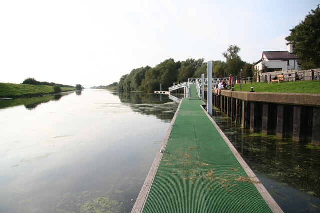
Anton's Gowt, Lincolnshire.
© Copyright
Richard Croft and licensed for reuse under this
Creative Commons Licence.
|
In laying out the works, he divided them according to their
levels, placing Wildmore and West Fen in one plan, and East Fen in
another. In draining the former, the outlet was made by
Anton's Gowt, about two miles and a half above Boston, and by Maud
Foster, a little below that town. But both of these, being
found too narrow and shallow, were considerably enlarged and
deepened, and provided with double sluices and lifting gates: one
set pointing towards the Witham, in order to keep out the tides and
river floods; the other to the land, in order to prevent the water
in summer from draining too low, and thereby hindering navigation as
well as the due irrigation of the lands. An extensive main
drain was also cut through the Wildmore and West Fens to the river
Witham, about twenty-one miles long and from eighteen to thirty feet
wide, the bottom being an inclined plane falling six inches in the
mile.
The level of the East Fen being considerably lower than that
of the Fens to the westward, it was necessary to provide for its
separate drainage, but on precisely the same principles. From
the levels which were taken, it appeared that the bottom of "the
Deeps," which formed part of the East Fen, was only two feet six
inches above the cill of Maud Foster Sluice, thirteen miles distant;
whereas its highest parts were but eight feet above the same point,
giving a fall of only an inch and eight-tenths per mile at low water
of neap tides. From some of the more distant parts of the same
Fen, sixteen miles from the outfall, there would only have been a
fall of five-tenths of an inch per mile at low water. It was
clear, therefore, that even the higher levels of the East Fen could
not be effectually drained by the outfall at Anton's Gowt or Maud
Foster; and hence arose the necessity for cutting an entirely
separate main drain, with an outfall at a point in the Wash outside
the mouth of the river Witham. [p.296-1]
|
Hobhole Drain, looking north from Ings Bridge near Hilldyke, Lincolnshire. [p.296-2]
© Copyright
Richard Croft and licensed for reuse under this
Creative Commons Licence.
|
This east main cut, called the Hobhole Drain, is about
eighteen miles long and forty feet wide, diminishing in breadth
according to its distance from the outfall; the bottom being an
inclined plane falling four inches in the mile towards the sluice at
Hobhole in the Wash. This drain is an immense work, defended
by broad and lofty embankments extending inland from its mouth, to
prevent the contained waters flooding the surrounding lands.
It is protected at its sea outlet by a strong sluice, consisting of
three openings of fifteen feet each. When the tide rises, the
gates, acting like a valve, are forced back and hermetically closed;
and when it falls, the drainage waters, which have in the mean time
accumulated, force open the gates again, and the waters flow into
the sea down to the level of low water. A connection was also formed
between the main drains emptying themselves at Maud Foster (three
miles higher up the Witham) and the Hobhole Drain, the flow being
regulated by a gauge; so that, during heavy floods, not only the low
land waters of the East Fen districts were effectually discharged at
Hobhole, but also a considerable portion of the drainage of the West
and Wildmore Fens.
An essential part of the scheme was the cutting of the
catchwater drains, which were carried quite round the base of the
high lands skirting the Fens; beginning with a six-feet bottom, and
widening out towards their embouchures to sixteen feet. The
principal work of this kind commenced near Stickney, and was carried
eastward towards Wainfleet, to near the Steepings river. It
was connected at Cowbridge with the main Hobhole Drain, into which
the highland waters brought down by the catchwater drain were thus
carried, without having been allowed, until reaching that point, to
mix with the Fen drainage at all.
It would be tedious to describe the works more in detail; and
perhaps the outline we have given, aided by the maps of the
district, will enable the reader to understand the leading features
of Mr. Rennie's comprehensive design. The works were
necessarily of a very formidable character, the extent of the main
and arterial drains cut during the seven or eight years they were
under execution being upwards of a hundred miles. They often
dragged for want of funds, and encountered considerable opposition
in their progress; though the wisdom of the project was in all
respects amply justified by the result. [p.297]
When the drainage of Wildmore and West Fens was finished,
forty thousand acres of valuable land were completely reclaimed, and
in a few years yielded heavy crops of grain. East Fen was
attacked the last, the difficulties presented by its formidable
chain of lakes being by much the greatest; but the prize also was by
far the richest. When the East Fen waters were drained off,
the loose black mud settled down into fertile soil. Boats,
fish, and wild-fowl disappeared, and the plough took their place.
After being pared and burnt, the land in the East Fen yielded two
and even three crops of oats in succession, of not less than ten
quarters to the acre.
The cost of executing the drainage had no doubt been very
great, amounting to about £580,000 in all, inclusive of expenditure
on roads, &c.; against which had to be set the value of the lands
reclaimed. In 1814 Mr. Anthony Bower, surveyor and valuer,
estimated their improved rental at £110,561; and allowing five per
cent. on the capital expended on the works, we thus find the
increased net value of the drained lands to be not less than £81,000
per annum, which, at thirty years' purchase, gives a total increased
value of nearly two millions and a half sterling! [p.299]
It was a matter of great regret to Mr. Rennie that his design
was not carried out as respected the improved outfall of the Witham.
It was an important part of his original plan that a new and direct
channel should be cut for this river from Boston down to deep water
at Clayhole, where the tide ebbed out to the main sea level, and
there was little probability of the depth being materially
interfered with by silting for many years to come. This new
channel would have enabled all the waters—lowland as well as
highland—to be discharged into the sea with the greatest ease and
certainty. It would also have completely restored the
navigation of the river, which had become almost entirely lost
through the silting up of its old winding channel.
But the River Witham was under the jurisdiction of the
corporation of Boston, who were staggered by the estimated cost of
executing the proposed works, though it amounted to only £50,000.
Accordingly, nothing was done to carry out this part of the design,
and the channel continued to get gradually worse, until at length it
was scarcely possible even for small coasters to reach Boston Quay.
As late as the year 1826 the water was so low that little boys were
accustomed to amuse themselves by wading across the river below the
town even at high water of neap tides. The corporation were at
last compelled to bestir themselves to remedy this deplorable state
of affairs, and they called in Sir John Rennie to advise them in
their emergency. The result was, that as much of the original
plan of 1800 [p.300] was carried
out as the state of their funds would permit: the lower part of the
channel was straightened, and the result was precisely that which
the engineer had more than thirty years before anticipated.
The tide returned to the town, the shoals were removed, and vessels
drawing from twelve to fourteen feet water could again come up to
Boston Quay at spring tides.
Mr. Rennie was equally successful in carrying out drainage
works in other parts of the Fens, on the same simple but
comprehensive principles. [p.301]
He thus drained the lowlands of Great Steeping, Thorpe, Wainfleet
All Saints, Forsby, and the districts thereabout, converting the
Steepings river into a catchwater drain, and effectually reclaiming
a large acreage of highly valuable land. He was also consulted
as to the better drainage of the North Level, the Middle Level,
South Holland, and the Great Bedford Level; and his valuable reports
on these subjects, though not carried out at the time, for want of
means, or of public spirit on the part of the landowners, laid the
foundations of a course of improvement which has gone on until the
present day. It is much to be regretted that his plan of 1810,
for the drainage of the Great Level, by means of more effectual
outfalls and a system of intercepting catchwater drains, was not
carried out; for there is every reason to believe that it would have
proved as completely successful as his drainage of the Fens of
Lincolnshire. The only part of his scheme that was executed
was the Eau Brink Cut, for the purpose of securing a more effectual
outfall of the river Ouse into the Wash near King's Lynn.
The necessity for this work will be more clearly understood
when we explain the circumstances under which its construction was
recommended. It will be observed from the map of the Fen
district (vol. i. p.37), that the river Ouse flows into the shallows
of the Wash near the town of King's Lynn, where it is charged with
the waters of the Great Bedford Level as well as of Huntingdon,
Bedford, and Cambridge, and of the highlands of the western parts of
Norfolk and Suffolk. Immediately above Lynn, the old river
made an extensive bend of about five miles in extent, to a point
called German's Bridge. This channel was of very irregular
breadth, and full of great sand beds which were constantly shifting.
In some places it was as much as a mile in width, and divided into
small streams, which varied according as the tidal or the fresh
waters were, for the time being, most powerful. During floods,
the flow of the river was so much obstructed that the waters could
not possibly get away out to sea during the ebb, so that at the next
rise of the tide they were forced back into the interior, and thus
caused serious inundations in the surrounding country.
Much good land which had formerly been productive, had become
greatly deteriorated, or was apparently lost for agricultural
purposes. Some districts were so constantly flooded, and
others were so wet, that they were rapidly returning to their
original state of reeds and sedge. In the neighbourhood of
Downham Eau, the harvest-men were, in certain seasons, obliged to
stand upon a platform to reap their corn, which was carried to and
from the drier parts in boats; and some of the farmers, in like
manner rowed through their orchards in order to gather the fruit
from the trees. A large portion of Littleport Fen, in the
South Level, was let at a shilling an acre, and, in the summer-time,
cattle were turned in amongst the reed and "turf-bass," and were not
seen again for weeks. In Marshland Fen, the soil was so soft
that wooden shoes, or flat boards, were nailed on the horses' feet
over the iron ones, to prevent them from sinking into the soil.
The fresh waters were in this way penned up within the land
to the extent of about seven feet; and over an extensive plain, such
as the Bedford Level, where a few inches of fall makes all the
difference between land drained and land drowned, it is clear how
seriously this obstruction of the Ouse outfall must have perilled
the agricultural operations of the district. Until, therefore,
this great impediment to the drainage of the Level could be removed,
it was clear that no inland works could be of any permanent
advantage. The remedy which Mr. Rennie proposed was, to cut
off the great bend in the Ouse by making a direct new channel from
Eau Brink, near the mouth of Marshland Drain, to a point in the
river a little above the town of Lynn, as shown in the plan on the
next page. The cut was to be about three miles in length, and
of sufficiently capacious dimensions to contain the whole body of
the river. By thus shortening the line of the stream, Mr.
Rennie calculated that the channel would be kept clear of Silt by
the greater velocity of the current, and that the fresh waters would
at the same time be able to force their way out to sea without
difficulty.
|

|
An Act was accordingly obtained, enabling the Eau Brink to be
cut; but several years passed before any steps were taken to carry
out the works. They were not actually begun until the year
1817, when Mr. Rennie was formally appointed the chief engineer.
After about four years' labour the cut was finished and opened, and
its immediate effect was to give great relief to the whole of the
district watered by the Ouse. An extra fall of not less than
five feet and a half was obtained at St. German's, by which the
surface of the waters throughout the whole of the Middle and South
Levels was reduced in proportion. Thus the pressure on all the
banks along the rivers of the Level was greatly relieved, whilst
inundations were prevented, and the sluices provided for the
evacuation of the inland waters were enabled effectually to
discharge themselves.
|
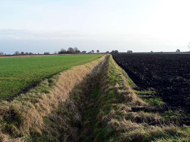
A
typicalLincolnshire landscape: Metheringham Fen, farmland south of Little Drove.
© Copyright
Ian Carrington and licensed for reuse under this
Creative Commons Licence.
|
By labours such as these an immense value has been given to
otherwise worthless swamps and wastes. The skill of the
engineer has enabled the Fen farmers to labour with ever-increasing
profit, and to enjoy the fruits of their industry in comparative
health and comfort. No wonder that they love the land which
has been won by toil so protracted and so brave. Unpicturesque
though the Fens may be to eyes accustomed to the undulating and hill
country of the western districts of England, they nevertheless
possess a humble beauty of their own, especially to eyes familiar to
them from childhood. The long rows of pollards, with an
occasional windmill, stretching along the horizon as in a Dutch
landscape—the wide extended flats of dark peaty soil, intersected by
dykes and drains, with here and there a green tract covered with
sleek cattle—have an air of vastness, and even grandeur, which is
sometimes very striking. To this we may add, that the churches
of the district, built on sites which were formerly so many oases in
the watery desert, loom up in the distance like landmarks, and are
often of remarkable beauty of outline.
It has been said of Mr. Rennie that he was the greatest
"slayer of dragons" that ever lived,—this title being given in the
Fens to persons who, by skill and industry, have perfected works of
drainage, and thereby removed the causes of sickness and disease,
typified in ancient times as dragons or destroyers. [p.305]
In this sense, certainly, Mr. Rennie is entitled, perhaps more than
any other man, to this remarkable appellation.
――――♦――――
CHAPTER VI.
MR. RENNIE'S BRIDGES.
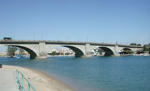
London Bridge, rebuilt at in Lake Havasu City,
Arizona, in 1971, the sole survivor of
Rennie's three great Thames bridges. Picture
Wikipedia (Aran
Johnson).
THE bridges
erected by our engineer are amongst the finest of his works, and
sufficient of themselves to stamp him as one of the greatest masters
of his profession. We have already given a representation of
his first bridge, erected over the Water of Leith, near Edinburgh,
the forerunner of a series of similar structures unrivalled for
solidity and strength, contrived with an elegance sometimes ornate,
but for the most part of severe and massive simplicity.
Unlike some of his contemporaries, Mr. Rennie did not profess
a disregard for theory; for he held that true practice could only be
based on true theory. Taken in the sense of mere speculative
guessing, however ingenious, he would have nothing to do with it;
but as matter of inference and demonstration from fixed principles,
he held by theory as his sheet-anchor. His teacher, Professor
Robison, had not failed to impress upon him its true uses in the
pursuit of science and art; and he never found reason to regret the
fidelity with which he carried out his instructions in practice.
In the year 1793, Mr. Rennie had the advantage of much close
personal intercourse with his old friend the Professor, who paid him
a visit at his house in London, for the express purpose of
conferring with him upon mechanical subjects. In the letter
announcing the object of his visit, Dr. Robison candidly avowed that
it was in order "that he might extract as much information from him
as possible." The Doctor had undertaken to prepare the
articles on Mechanics for the third edition of the 'Encyclopedia
Britannica,' and he believed he should be enabled to impart an
additional value to his writings by throwing upon them the light of
Rennie's strong practical judgment. He proposed to take a
lodging in the immediate neighbourhood of Rennie's house, then in
Great Surrey Road, and to board with him during the day; but Rennie
would not listen to this proposal, and insisted on being the
Professor's entertainer during the period of his visit.
One of the points which he particularly desired to discuss
with Mr. Rennie was the theory of the equilibrium of arches—a
subject at that time very imperfectly understood, but which the
young engineer had studied with his usual energy and success.
He had clearly proved that the proper proportion and depth of the
key-stone to that of the extrados (or exterior curve) should be in
proportion to the size and form of the arch and the materials of
which it was composed; and he had also established the ratio in
which the arch-stones should increase from the key-stone to the
piers or abutments.
Up to this time there had been no rules laid down for the
guidance of the engineer or architect,—who worked very much in the
dark as to principles; and it was often a matter entirely of chance
whether a bridge stood or fell when the centres were removed.
According to the views of Hutton and Attwood, the weight upon the
haunches and abutments, to put the arch in a state of equilibrium so
that it should stand, was unlimited; whereas Mr. Rennie established
the limit to which the countervailing force or weight on the
extrados should be confined. Hence he adopted the practice of
introducing a flat inverted arch between the extrados of each two
adjoining arches, (at the same time increasing the width of the
abutment,)—the radii of the voussoirs or arch-stones being continued
completely through them. And in order to diminish the masonry,
the lower or foundation course was inclined also,—thus combining the
work more completely together, and enabling it better to resist the
lateral thrust.
Dr. Robison had much discussion with Mr. Rennie on these and
many other points, and the information he obtained was shortly after
worked up into numerous original contributions of great value;
amongst which may be mentioned his articles in the 'Encyclopedia' on
the Arch, Carpentry, Roof, Waterworks, Resistance of Fluids, and
Running of Rivers [p.308]—on all
of which subjects Mr. Rennie had communicated to him much original
information. It may readily be imagined that the evenings
devoted by Dr. Robison to conversation and discussion on such topics
at Rennie's house were of interest and advantage to both; and when
the Doctor returned to his Edinburgh labours, he carried with him
the cordial affection and respect of the engineer, who continued to
keep up a correspondence with him until the close of his life.
In the early part of his career Mr. Rennie was called upon to
furnish designs of many bridges, principally in Scotland, which,
however, were not carried out, in most cases because the requisite
funds could not be raised to build them. Thus, in 1798, he
designed one of eight cast-iron arches to span the river Don at
Aberdeen. Four years later he was called upon to furnish
further designs, when he supplied three several plans, two of
granite bridges; but the structures were of too costly a character,
and the people of Aberdeen did not carry them out.
The first important bridge which Mr. Rennie was authorised to
execute was that across the Tweed at Kelso, and it afforded a very
favourable specimen of his skill as an architect. It was
designed in 1799 and opened in 1803. It consists of five
semi-elliptical arches of 72 feet span, each rising 28 feet, and
four piers each 12 feet thick, with a level roadway 23 feet 6 inches
wide between the parapets, and 29 feet above the ordinary surface of
the river. The foundations were securely laid upon the solid
rock in the bed of the Tweed, by means of coffer-dams, and beneath
the deepest part of the river. The Piers and abutments were
ornamented with three-quarter columnar pilasters of the Roman Doric
order, surmounted by a plain block cornice -and balustrade of the
same character. The whole of the masonry was plain rustic coursed
work, and in style and execution it was regarded as one of the most
handsome and effective structures of its kind.
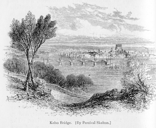
The Kelso Bridge may almost be said to have formed the commencement
of a new era of bridge-building in this country. The semi-elliptical
arches, the columnar pilasters on the piers, the balustrade, and the
level roadway, are the same as in Waterloo Bridge, except as regards
size and character; so that Kelso Bridge may be regarded as the
model of the greater work. We believe it was one of the first
bridges in this country constructed with a level roadway.
Some of the old-fashioned bridges were excessively steep and to get
across them was like climbing over the roof of a house. There was a
heavy pull on one side and a corresponding descent on the other. The
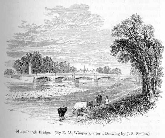
old bridge across the Esk at Musselburgh, forming part of the high
road between Edinburgh and London, was of this precipitous
character. It was superseded by a handsome and substantial bridge,
with an almost level roadway, after a design by Rennie. When the
engineer was taking the work off the hands of the contractor, one of
the magistrates of the town, who was present, asked a countryman who
was passing at the time With his cart how he liked the new brig?
"Brig!" said the man, "it's nae brig ava! ye neither ken whan ye're
on't, nor whan ye're off't!"
Mr. Rennie's boldness in design grew with experience, and when
consulted as to a bridge near Paxton, over the Whitadder (a rapid
stream in Berwickshire), he proposed, in lieu of the old structure,
which had been carried away by a flood, a new one of a single arch
of 150 feet span; but unhappily the road trustees could not find the
requisite means for carrying it into effect. |
Rennie's bridge over the River Esk at Musselburgh, East Lothian, Scotland.
Picture Wikipedia (Renata).
|
Another abortive but grand design was proposed by him in
1801. He had been requested by the Secretary of State for
Ireland to examine the road through North Wales to Holyhead, with
the object of improving the communication with Ireland, which was
then in a wretched state. The connection of the opposite
shores of the Menai Strait by means of a bridge was considered an
indispensable part of any improvement of that route; and Mr. Rennie
proposed to accomplish this object by a single great arch of cast
iron 450 feet in span,—the height of its soffit or crown to be 150
feet above high water at spring tides. [p.312]
A similar bridge of 350 feet span, having its crown 100 feet above
the same level, was also proposed by him for the crossing of Conway
Ferry.
These bridges were to be manufactured after a plan invented
by Mr. Rennie in 1791, and communicated by him to Dr. Hutton in
1794; and he was strongly satisfied of its superiority to all others
that had been proposed. The designs were alike bold and
skilful, and it is to be regretted that they were not carried out;
for their solidity would not only have proved sufficient for the
purposes of a roadway, but probably also of a locomotive railway.
In that case, however, we should have been deprived of the
after-display of engineering ability in bridging the straits at
Menai and the ferry at Conway. Rennie's plans were, however,
thought far too daring, and the expense of executing them far too
great. The whole subject was therefore allowed to sleep for
many years, until eventually Telford spanned both these straits with
suspension road bridges, and Robert Stephenson afterwards with
tubular railway bridges, at a total cost of about a million
sterling.
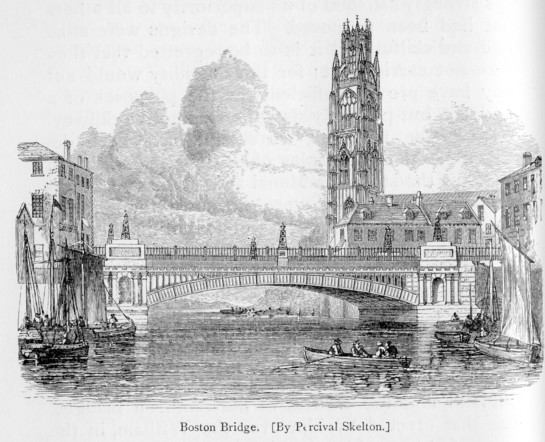
The first bridge constructed by Mr. Rennie in England, and
the earliest of his cast-iron bridges, was that erected by him over
the Witham, in the town of Boston, Lincolnshire, in 1803. [p.313]
It consists of a single arch of iron ribs, forming the segment of a
circle, the chord of which is 80 feet. It is simple yet
elegant in design; its flatness and width contributing to render it
most convenient for the purpose for which it was intended—that of
accommodating the street-traffic of one of the most prosperous and
busy towns in the Fens.
Mr. Rennie's reputation as an engineer having become well
established by works of this class, he was, during the remainder of
his professional career, extensively consulted on this branch of
construction; [p.314] and many
solid memorials of his skill in bridge-work are to be found in
different parts of the kingdom. But the finest of the
buildings of this character which were erected by him are
unquestionably those which adorn the metropolis itself.
The project of erecting a new bridge to connect the Strand,
near Somerset House, with the Surrey side of the Thames at Lambeth,
was started by a Bridge Company in 1809—a year distinguished for the
prevalence of one of those joint-stock fevers which periodically
seize the moneyed classes of this country. The first plan
considered was the production of Mr. George Dodds, a well-known
engineer of the time. The managing committee were not
satisfied with the design, and referred it to Mr. Rennie and Mr.
Jessop for their opinion. It was found to be for the most part
a copy of M. Peyronnet's celebrated bridge of Neuilly, with
modifications rendered necessary by the difference of situation and
the greater width of the river to be spanned. It showed a
bridge of nine arches of 130 feet span; each being a compound curve,
the interior an ellipsis, and the face or exterior a segment of a
circle, as in the bridge at Neuilly. [p.316]
The reporting engineers pointed out various objections to the
design, as well as to the plan proposed for founding the piers.
The result was, that no further steps were taken to carry out Mr.
Dodd's plan; but when the Act authorising the construction of the
bridge had been obtained, the committee again applied to Mr. Rennie;
and on this occasion they requested him to furnish them with the
design for a suitable structure. [p.317]
The first step which he took was to prepare an entirely fresh
chart of the river and the adjacent shores, after a careful and
accurate survey made by Mr. Francis Giles. In preparing his
plan, he kept in view the architectural elegance of the structure as
well as its utility; and while he designed it so as to enhance the
beauty of the fine river front of Somerset House, by contriving that
the face of the northern abutment should be on a line with its noble
terrace, he laid out the roadway so that it should be as nearly upon
a level with the great thoroughfare of the Strand as possible—the
rise from that street to the summit on the bridge being only 1 in
250, or about two feet in all. Two designs were prepared—one
of seven equal arches, the other of nine; and the latter being
finally approved by the committee as the less costly, it was ordered
to be carried into effect.
The structure, as executed, is an elegant and substantial
bridge of nine arches of 120 feet span, with piers 20 feet thick;
the arches being plain semi-ellipses, with their soffits or crowns
30 feet above high water of ordinary spring tides. Over the
points of each pier are placed two three-quarter Doric column
pilasters, after the design of the temple of Segesta in Sicily.
These pilasters are 5 feet 8½ inches diameter at the base, and 4
feet 4 inches at the under side of the capital, forming recesses in
the roadway 17 feet wide and 5 feet deep. The depth of the
arch-stones at the crown is 4 feet 6 inches, and they increase
regularly to 10 feet at the haunches. Between each pair of
arches, at the level of 19 feet above the springing, there is an
inverted arch, the stones of which are 4 feet 6 inches deep at the
crown, and decrease regularly on each side as they unite and abut
against the extrados or backs of the voussoirs of the main haunches.
The abutments are 40 feet in thickness at the base, and decrease to
30 feet at the springing. The cope of the arches and piers is
surmounted by a Grecian Doric block-cornice and entablature, upon
which is placed a balustrade parapet 5 feet high. The total
width of the bridge from outside to outside of the parapets is 45
feet. The footpaths on each side are 7 feet wide, and the
roadway for carriages 28 feet. There were originally four sets
of landing stairs two to each abutment; and the arrangement of this
part of the work has been much admired, on account of its
convenience, as well as because of its architectural elegance.
In the construction of this bridge there are four features of
distinctive importance to be noted:—1st. The employment of
coffer-dams in founding piers in a great tidal river—an altogether
new use of that engineering expedient, though now become customary.
2nd. The ingenious method employed for constructing, floating, and
fixing the centres; since followed by other engineers in works of
like magnitude. 3rd. The introduction and working of granite
stone to an extent before unknown, and in much larger and more
substantial pieces of masonry than had previously been practised.
4th. The adoption of elliptical stone arches of an unusual
width, though afterwards greatly surpassed by the same engineer in
his New London Bridge. |
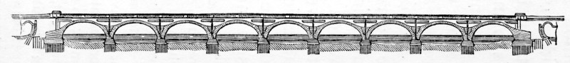
Section of Waterloo Bridge.
|
Mr. Rennie invariably took the greatest pains in securing the most
solid foundations possible for all his structures, and especially of
his river works, laying them far below the scour of the river, at a
depth beyond all probable reach of injury from that cause. The
practice adopted in founding the Piers of the early bridges across
the Thames was to dredge the bottom to a level surface, and build
the foundations on the bed of the river, protecting them outside by
rubble, by starlings, or by sheet-piling. Mr. Dodds had proposed to
follow the method employed by Labelye at Westminster Bridge, of
founding the piers by means of caissons; but Mr. Rennie insisted on
the total insufficiency of this plan, and that the most effectual
method was by means of coffer-dams. This would, no doubt, be more
costly in the first instance, but vastly more secure; and he foresaw
that the inevitable removal of the piers of Old London Bridge, by
increasing the current of the river, would severely test the
foundations of all the bridges higher up the stream —which proved to
be the case. Having already extensively employed coffer-dams in
getting in the foundations of the London and East India Dock walls,
he had no doubt as to their success in this case; and they were
adopted accordingly. [p.320]
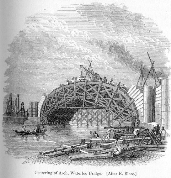
Mr. Rennie also introduced a practice of some novelty and importance
in the centering upon which the arches of the bridge were built. He
adopted the braced principle. The centres spanning the whole width
of the arch were composed of eight ribs each, formed in one piece,
resting upon the same number of solid wedges, supported by inclined
tressels placed upon longitudinal bearers, firmly fixed to the
offset of the piers and abutments. At the intersecting point of the
bearers or braces in each rib there was a cast-iron box, with two
holes or openings in it, so that the butt-ends rested firmly against
the metal; and to prevent them from acting like so many wedges to
tear the rib to pieces when the vertical weight of the arch began to
act upon them, pieces of hard wood were driven firmly into the holes
above described, to check the effect of the bearers or struts of the
ribs; and this arrangement proved completely successful. The eight
ribs were firmly connected together by braces and ties, so as to
form one compact frame, and the curve or form of the arch was
accurately adjusted by means of transverse timbers, 12 inches wide
and 6 inches thick, laid across the whole of the ribs, set out to
the exact form of the curve by ordinates from the main or
longitudinal axis of the ellipsis; and in proportion as the
voussoirs or arch-stones were carried up from the adjoining piers,
the weight which had been laid upon the top of the centre to keep it
in equilibrium according to the form of the arch during
construction, was gradually removed as it advanced towards
completion. When the arch was about two-thirds completed, a small
portion of it was closed with the centre, and the remaining part of
each side was brought forward regularly by offsets to the crown
until the whole was finished. Each key-stone was accurately fitted
to its respective place, and the last portion of each, for the space
of about eighteen inches, was driven home by a heavy wooden ram or
pile-engine, so as almost to raise the crown of the arch from the
centre.
About ten days after the main arches had been completed, and the
inverts and spandrel walls between them carried up to the proper
height, the arches were gently slackened, to the extent of about two
inches, so as to bring each to its bearing to a certain extent. This
was effected by driving back the wedges upon which the ribs of the
centres rested, by means of heavy wooden rams attached to them, so
that they could swing backwards and forwards with great facility
when any external force was applied to them; and this was done by
ropes worked by hand-labour. After the first striking or slackening,
the arches were allowed to stand for ten days, when the wedges were
driven back six inches farther. After ten days more the wedges were
driven back sufficiently to render the arch altogether clear of the
centering. By this means the mortar was firmly imbedded into all the
joints, and the arch came gradually to its ultimate bearing without
any undue crushing. In order to ascertain whether any change of form
took place, three straight lines were drawn in black chalk on the
extreme face of the arch previous to commencing the operations of
striking the centre—one horizontally in the centre of the voussoirs
forming the crown, and two from the haunches of the arch, each
intersecting the first line at about 25 feet on each side of the
keystone; so that if there had been any derangement of the curve or
irregular sinking, it would at Once have been clearly apparent.
After the centres had been removed, it was found that the sinking Of
the arches varied from 2½ to 3¼ inches, which was as nearly as
possible the allowance made by the engineer in designing the work;
the whole plan being worked out with admirable precision and
accuracy.
The method of fixing and removing the centres was entirely new;
being precisely the same as was afterwards followed by Mr. Robert
Stephenson in fixing the wrought-iron ribs of the Conway and
Britannia bridges—that is, by constructing them complete upon a
platform adjacent to the river, and floating them between the piers
on barges expressly contrived for the purpose. They were then raised
into their proper places by four strong screws, 8 inches in diameter
and 4 feet long, fixed in a strong cast-iron box firmly bedded in
the solid floor of the barge. The apparatus worked so well and
smoothly, that the whole centre, consisting of eight ribs, each
weighing about fifty tons, was usually placed within the week.
The means employed by Mr. Rennie for forming his road upon the
bridge, were identical with those adopted by Mr. Macadam at Bristol
some six years later. But the arrangement constituted so small a
part of our engineer's contrivance, that, as in many other cases, he
made no merit of it. When the clay-puddle placed along the intended
roadway was sufficiently hard, he spread a stratum of fine screened
gravel or hoggins, which was carefully levelled and pressed down
upon the clay. This was then covered over with a layer of equally
broken flints, about the size of an egg; after which the whole was
rolled close together, and in a short time formed an admirable "
macadamised " road. Mr. Rennie had practised the same method of
making roads over his bridges long before 1809; and he continued to
adopt it in all his subsequent structures.
The whole of the stone required for the bridge (excepting the
balustrades, which were brought ready worked from Aberdeen) was hewn
in some fields adjacent to the erection on the Surrey side. It was
transported to the work upon trucks drawn along railways, in the
first instance over temporary bridges of wood; and it is a singular
circumstance that nearly the whole of the material was drawn by one
horse, called "Old Jack"—a most sensible animal, and a great
favourite. His driver was, generally speaking, a steady and
trustworthy man, though rather too fond of his dram before
breakfast. As the railway along which the stone was drawn, passed in
front of the public-house door, the horse and truck were usually
pulled up while Tom entered for his "morning." On one occasion the
driver stayed so long that "Old Jack," becoming impatient, poked his
head into the open door, and taking his master's coat-collar between
his teeth, though in a gentle sort of manner, pulled him out from
the midst of his companions, and thus forced him to resume the day's
work.
The bridge was opened with great ceremony by His Royal Highness the
Prince Regent, attended by y the Duke of Wellington and many other
distinguished personages, on the 18th of June 1817. It was
originally named the Strand Bridge; but after that date the name was
altered to that of "Waterloo," in honour of the Duke. At the
opening, the Prince Regent offered to confer the honour of
knighthood on the engineer, who respectfully declined it. Writing to
his friend Whidbey, he said, "I had a hard business to escape
knighthood at the opening." He was contented with the simple,
unadorned name of John Rennie, engineer and architect of the
magnificent structure which he had so successfully brought to
completion.
 |
An artist's impression of the "Strand Bridge", 1814.
Rennie's Waterloo Bridge, opened on the 18th June, 1817.
|
Waterloo Bridge is indeed a noble work, and probably has not
its equal for size, beauty, and solidity. Dupin characterised
it as a colossal monument, worthy of Sesostris or the Caesars.
Canova, during his visit to England, was particularly struck by the
fact, that the trumpery Chinese bridge, in St. James's Park, should
be the production of the Government, whilst Waterloo Bridge was the
enterprise of a private company. Like all Rennie's works, it
was built for posterity. That it should not have settled more
than a few inches—not five in any part—after the centres were
struck, is an illustration of solidity and strength probably without
a parallel. We believe that not a crack is visible in the entire
work. [p.326]
The necessity for further bridges across the Thames increased
with the growth of population on both sides of the river. In
the year 1813, a Company was formed to provide a bridge at some
point intermediate between Blackfriars and London Bridge, of which
Mr. Rennie was appointed the engineer. The scheme was at first
strongly opposed by the Corporation, on the ground of the narrowness
of the river at the point at which it was proposed to erect the new
structure; but the public demands being urgent, the necessary Act
was at length allowed to pass, but the Corporation insisted on the
provision of a very large waterway, so that the least possible
obstruction should be offered to the navigation. Mr. Rennie
prepared a design to meet the necessities of the case, and in order
to secure the largest waterway, he projected his well-known
Southwark Bridge—extending from Queen Street, Cannon Street, to
Bridge Street, Southwark. It consists of three cast-iron
arches, with two stone piers and abutments. The arches are
flat segments of circles, the centre one being not less than 240
feet span (or 4 feet larger than Sunderland Bridge, the largest
cast-iron arch that had until then been erected), rising 24 feet,
and springing 6 feet above high water of spring tides. The two
side arches are of 210 feet span, each rising 18 feet 10 inches, and
springing from the same level. The two piers were 24 feet wide
each at the springing, and 30 feet at the base.
|
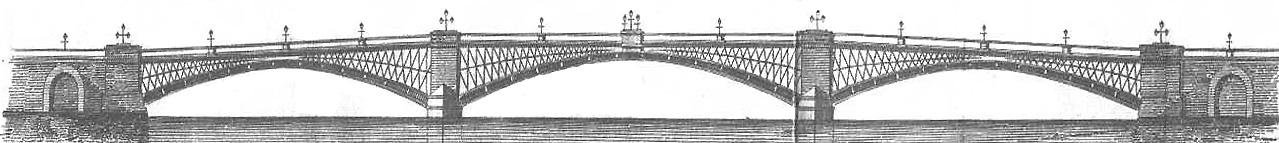
Sectional view of Southwark Bridge; "as an example of arch construction, it
stands confessedly unrivalled as regards its colossal
proportions, its architectural effect, and the general simplicity and massive
character of its details" (Robert Stephenson).
|
The works commenced with the coffer-dam of the south pier on
the Southwark side, and the first stone was laid by Admiral Lord
Keith about the beginning of 1815. All the centering for the
three arches was fixed by the autumn of 1817, and the main ribs were
set by the end of April 1818. The centres were struck by the
end of the month of June following, and completely removed by the
middle of October; and the, bridge was opened for traffic in March
1819.
In the course of this work great precautions were used in
securing the foundations of the piers. The river was here at
its narrowest and deepest point, the bed being 14 feet below low
water of ordinary spring tides. The coffer-dams were,
therefore, necessarily of great depth and strength to resist the
pressure of the strong body of water, as well as the concussion of
the barges passing up and down the river, which frequently drove
against them. Hence the dams were constructed in the form most
capable of resisting external pressure, and yet suitable to the
dimensions of the foundations. The masonry and iron work of
the bridge were erected with great care and completeness. The
blocks of stone in the piers were accurately fitted to their places
by moulds, and driven down by a heavy wooden ram. The least
possible quantity of finely tempered mortar was used, so that every
part should have a perfectly true permanent bearing. Great
care was also taken in the selection of the blocks. The
exterior of the piers was constructed of hard silicious stone
brought from Craigleith Quarry, near Edinburgh, and Dundee; the
interior, from the bottom of the foundations to the springing of the
arches, of hard Yorkshire grit; while that part of the piers and
abutments from which the arches spring consisted of the hardest and
closest blocks of Cornish and Aberdeen granite: in fine, it may be
affirmed that a more solid piece of masonry does not exist than
Southwark Bridge.
The iron work consists of eight arched ribs, the main
strength of the arches being embodied in their lower parts, which
are solid. The lower or main arch is divided into thirteen
pieces, with a rib 5½ inches thick at the top and bottom, and 2½
inches in the centre. The joints radiate outwards from the
lower edge, and form so many cast-iron instead of stone voussoirs,
from 6 to 8 feet deep and 13 feet long. At the junction of
each of these main rib pieces there are transverse plates of the
same depth, having flanges cast upon them on both sides in a wedge
form, so that the ends of the main rib piers fit into them on one
side, whilst on the other there is a cast-iron wedge, driven in
between the rib and flange piece, and enabling the whole to be
accurately adjusted and connected together. In addition to
this, each rib piece had a flange, cast at each end with a certain
number of holes three-quarters of an inch in diameter, into which
wrought-iron screw bolts were introduced to connect the whole firmly
together in the direction of the arch. These rib pieces were
also of great importance during construction, the chief dependence
being placed upon their lateral thrust in holding the arches
together.
At each pier and abutment there was a similar cast-iron bed
or abutting plate, let accurately 1½ inch into the stone; but
between the end of each main rib which sprang from this plate there
was a groove cut out of the solid stone behind the springing plates
and main iron ribs of the arches, inches wide, 3 inches thick at the
top, and 2 inches at bottom. The groove was accurately dressed
and polished. Three cast-iron wedges, 9 feet long, 6 inches
wide, and 3¼ inches thick at top and 2 inches at bottom, were then
made and most accurately chipped and filed, so as to fit exactly the
groove above mentioned to within 12 inches of its bottom. When
the whole of these wedges at both ends of the arch had been put into
their places, they were carefully driven home to the bottom of the
grooves at the same time by heavy wooden rams, by which means the
ribs of the arches were relieved from the centres and took their own
bearing. In other words, the arches were keyed from the
abutments only, instead of from the centre, as is usual in bridges
of stone.
This was an extremely delicate and nice process, as it
required that the variations of the thermometer should be carefully
observed, in order that each operation should be carried on at as
nearly as possible the same degree of temperature, otherwise the
form of the arch would have been distorted, the vertical and lateral
pressure of the different parts would have been affected, and an
undue strain thrown upon the abutments as well as the different
parts of the arch. But so nicely was the whole operation
arranged and adjusted, that nothing of the kind occurred: the parts
remained in perfect equilibrium; not a bolt was broken, and not the
smallest derangement was found in the structure after the process
had been completed.
The spandrel pieces attached to the top of the main ribs were
cast in the form of open diamonds or lozenges, connected together in
the transverse direction by two tiers of solid crosses laid nearly
horizontally—all closely wedged and firmly bolted together. In
addition to the transverse connecting plates cast in open squares,
there were also diagonal braces of cast iron, commencing at the
extremity of the outer rib of each arch and intersecting each other
so as to form a diamond-shaped space in the centre. These were
also secured at their ends by wedges and bolts, like the main rib
pieces.
After the main ribs of the arches were relieved from the
centres, and had taken their bearing, before the centres were
removed from beneath them, experiments were made how far they might
be affected by expansion and contraction, in proportion to the
different degrees of temperature to which the bridge might be
exposed; and for this purpose different gauges were made of brass,
iron, and wood. These gauges were firmly attached to the
middle or crown of the wooden centres, and divided into sixteenths
of an inch, and at each a Fahrenheit thermometer was placed; so that
the ends of the arch being fixed, the variation in the temperature
would be indicated by the rise and fall in the centre. The
observations were made daily in the morning, at midday, and at
sunset—for several months during summer and winter, when it was
ascertained that the arches rose and fell about one-tenth of an inch
for every 10 degrees of temperature, more or less.
The whole iron work is covered with solid plates, having
flanges cast on their upper side. These plates are laid in the
transverse direction and on the top of the spandrel walls, so that
they form a solid and compact cast-iron floor to support the
roadway. The cornice, which is cast hollow, is of the plain
Roman-Doric order, and is secured to the roadway-plates by strong
stays and bolts at proper intervals. The parapet consists of a
plinth, also cast hollow, with a groove at the top to receive the
railing, which is cast in the form of open diamonds corresponding
with the spandrels. The roadway is 42 feet wide from outside
to outside, and formed in the same manner as that over Waterloo
Bridge, which has been already described.
The total quantity of cast iron in the bridge is 3,620 tons,
and of wrought iron 112 tons. It has been said that an
unnecessarily large quantity of material has been employed; and no
doubt a lighter structure would have stood. But looking at the
imperfections of workmanship and possible flaws in the castings, Mr.
Rennie was probably justified in making the strengths such as he
did, in order to ensure the greatest possible solidity and
durability—qualities which eminently characterise his works, and
perhaps most of all, his majestic metropolitan bridges.
Although the Southwark Bridge was built before the Railway era,
which has given such an impetus to the construction of iron bridges,
it still stands pre-eminent in its class, and is a model of what a
bridge should be. Its design was as bold as its execution was
masterly. Mr. Robert Stephenson has well said of it that, "as
an example of arch construction, it stands confessedly unrivalled as
regards its colossal proportions, its architectural effect, and the
general simplicity and massive character of its details." [p.334]
――――♦――――
CHAPTER VII.
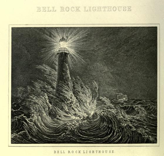
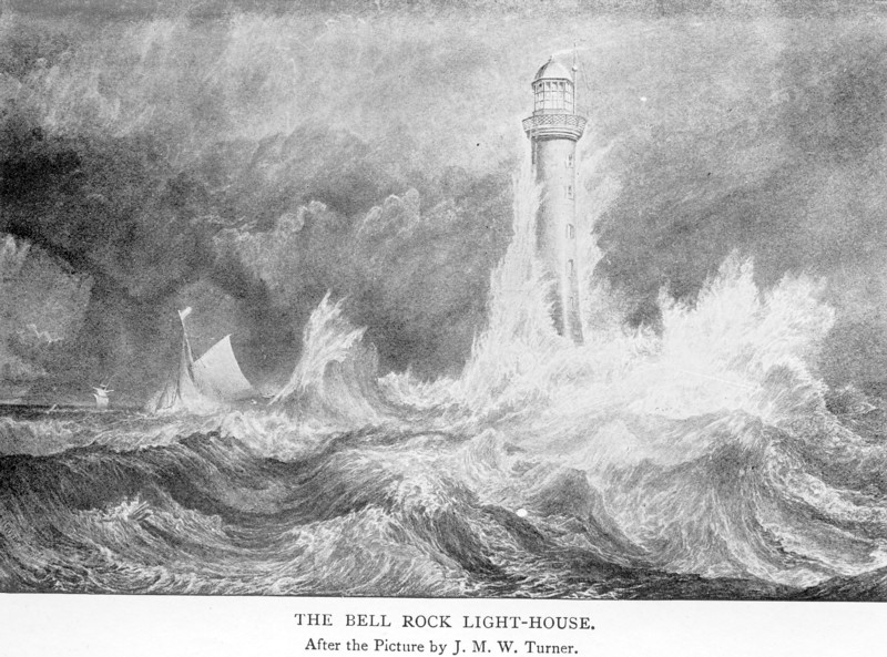
THE BELL ROCK LIGHTHOUSE.
Picture Internet Text Archive.
ABOUT eleven
miles east of the mainland of Scotland, near the entrances to the
Friths of Forth and Tay, lies an extensive ledge of rocks, which for
a long time was the terror of the seamen navigating that coast.
It is nearly two miles in length, being the crest of a mountain
rising from the sea bottom, only a small part of which is visible at
high water.
This sunken reef was a source of such peril, that, as early
as the fourteenth century, the Abbot of Arbroath caused a bell to be
placed upon the principal rock, the swinging of which by the motion
of the waves warned seamen of its dangers; and from this
circumstance it came to be called the Bell Rock. It is
affirmed that a notorious pirate, in order to plague the Abbot, cut
the bell from the rock, but was himself afterwards wrecked on the
very spot; and on this tradition Southey founded his beautiful
ballad of 'Ralph the Rover.' [p.335]
Nothing was done to replace the bell, or to set a beacon upon the
reef; and it remained in its dangerous state—the Eddystone of the
northern seas—until the beginning of the present century, when the
increasing commerce of Scotland, and the large number of vessels
wrecked there, had the effect of directing public attention to the
subject. As in the case of the Eddystone reef, the sailors' fear of
it was such, that in order to avoid its dangers, they hugged the
land so close as very frequently to run ashore.
Captain Basil Hall relates that when a boy, he was constantly
hearing of vessels getting wrecked through fear of the terrible Bell
Rock, which lay about ten leagues due north of the house at Dunglass
in which he was born. It is situated on the borders of East Lothian,
not far from the bold promontory on which Fast Castle stands,
overlooking the German Ocean. He states that "ships bound for the
Forth, in their constant terror of the dangerous reef, were not
content with giving it ten or even twenty miles of elbow-room, but
must needs edge off a little more to the south, so as to hug the
shore, in such a way that, when the wind chopped round to the
northward, as it often did, these over-cautious navigators were apt
to get embayed in a deep bight to the westward of Fast Castle. If
the breeze freshened before they could work out, they paid dearly
for their apprehensions of the Bell Rock, by driving upon ledges
fully as sharp, and far more extensive and inevitable. "Thus," he
says, "at that time, from three to four, and sometimes half-a-dozen,
vessels used to be wrecked every winter, within a mile or two of our
very door." [p.337] |
|
A Board of Commissioners had been appointed, under the powers of an
Act passed in 1786, for the purpose of erecting lighthouses at the
most dangerous parts of the coast of Scotland; and by the end of the
century several had been built,—one on the Isle of May at the
entrance of the Frith of Forth, another on the Cumbraes at the mouth
of the Frith of Clyde, and others on rocky promontories on the
eastern and western coasts, including the Orkneys. The lights
exhibited were of a rude kind, and consisted of coal fires in chauffers. All that was needed being a bright light, they probably
answered their purpose, though in a clumsy way. The most dangerous
reef of all, however, was still left without any protection; and
doubtless the delay in providing a light upon the Bell Rock arose
from the great difficulty and expense of erecting a suitable
structure on such a site.
In the winter of 1799, a tempest memorable for its violence and
fatal effects, ravaged the coasts, and drove from their anchors all
the ships lying in Yarmouth Roads. The greater number were wrecked
on the northern coast; and it was believed that many of them might
have been saved, had a light been fixed on the Bell Rock to point
out the entrances to the Friths of Forth and Tay. Among the other
lamentable shipwrecks which took place on the Inchcape about the
same time, was that of the 'York,' a seventy-four-gun ship, which
went down with all her crew. The reef was also a constant source of
danger to the shipping of Dundee, then rising in importance, as it
lay right in the main track of vessels making for the mouth of the
Tay from the German Ocean.
Many were the plans suggested for a lighthouse on the Bell Rock. In
1799 Captain Brodie submitted to the Commissioners of Northern
Lights his design of a cast-iron tower to be supported on four
pillars; but it was not adopted. In the mean time temporary beacons
of timber were employed; but these rarely stood the storms of a
single winter; and three successive structures of this kind were
completely swept away. Mr. Robert Stevenson and Mr. Downie also
proposed plans for the consideration of the Board between 1800 and
1804; but neither of them was adopted.
Considerable diversity of opinion continuing to exist, the
Commissioners determined to employ Mr. Rennie to examine the site
and report as to the best course to be pursued. He accordingly
proceeded to Scotland, and visited the Inchcape Rock on the 17th of
August, 1805, in company with Mr. Hamilton, one of the
Commissioners, and Mr. Stevenson, their surveyor.
After mature deliberation, Mr. Rennie sent in his report on the 30th
of December following. He recommended the erection of a substantial
lighthouse of stone, similar to that on the Eddystone, as being, in
his opinion, the only structure calculated to meet the necessities
of the case. [p.338] He regarded a
wooden building as objectionable, because of the perishable nature
of the material, and its liability to be destroyed by fire. Although
it would be possible to erect a lighthouse of cast iron, its cost at
that time would have been equal to one of stone, with which, in
point of durability, it was not to be compared. "I have therefore,"
he concluded, "no hesitation in giving a decided opinion in favour
of a stone lighthouse." With such examples as the Tour de Cordovan
near the entrance of the Garonne, and the Eddystone off the coast of
Cornwall, he held that there could be no doubt as to the superiority
of this plan to any other that could be proposed. Although the
Inchcape was not so long uncovered by the tide as the Eddystone
rock, and there might be greater delay in getting in the first four
or five courses of the foundation, this was only a question of time;
and he had no doubt that this difficulty would be overcome, and the
whole structure completed in the space of about four years.
In his report he further said: "Mr. Stevenson, to whose merit I am
happy to bear testimony, has been indefatigable in obtaining
information respecting this rock, and he has made a model of a stone
lighthouse nearly resembling that of the Eddystone, in which he has
proposed various ingenious methods of constructing the work by way
of facilitating the operations. I own, however, after fully
considering them, and comparing them with the construction of Mr.
Smeaton—I mean in the process of building—and also reflecting that
there are undoubted proofs of the stability of the Eddystone, that I
am inclined to give the latter the preference; its general
construction, in my opinion, rendering it as strong as can well be
conceived."
Taking, however, into account, that the foundation of the proposed
building lay so much lower in the sea, Mr. Rennie suggested that the
column should be somewhat higher, so that the eave of the cupola
should be about 100 feet above the surface of the rock, the
Eddystone being only 84 feet 6 inches,—though this alteration would
involve a somewhat greater diameter of the base. He further pointed
out that the pillar should be surrounded by such an extent of rock
as to diminish the force of the waves breaking at its foot. He also
proposed that the floor of the lower room of the lighthouse should
be 50 feet above the level of the rock, and from thence to the top
of the platform 35 feet; making a total height of 85 feet to the
platform or gallery. He recommended that argand lights should be
employed, with parabolic reflectors; and he suggested for
consideration the employment of carburetted hydrogen gas, then
coming into extensive use for lighting purposes. The cost of the
lighthouse, so constructed, he estimated at about £42,000.
The Commissioners adopted Mr. Rennie's report, and proceeded to
Parliament for the requisite powers, which were obtained in the
session of 1806; after which (on the 3rd of December following) they
unanimously appointed him the chief engineer for conducting the
work. At Mr. Rennie's recommendation, Mr. Stevenson was appointed
the assistant-engineer to superintend the operations on the spot,
and he placed under him two able foremen superintendents, Mr. Peter
Logan over the masons, and Mr. Francis Watt over the joiners
employed upon the lighthouse. Mr. Rennie was then requested to
report further, with plans and specifications of the various works
in detail; which he prepared and duly submitted to the Board.
|
Robert
Stevenson (1772–1850), Scottish civil engineer and
specialist in lighthouse construction. Picture: The
Internet Text Archive. |
In this second report of the 26th December following, Mr. Rennie
entered at great length into the description of stone to be used in
the building, based upon a personal inspection of the quarries at
Mylnefield near Dundee, at Arbroath, and at Aberdeen; and on his
recommendation it was determined to use blocks from the Rubieslaw
quarry at Aberdeen for the outer, and Dundee stone for the inner
masonry. He also repeated his advice, that in carrying out the work,
the plan of construction adopted by Smeaton in building the
lighthouse on the Eddystone should be mainly followed; one of the
few deviations consisting in the substitution of dovetailed pieces
of stone for chain bars in the joints both of the walls and the
floors. These recommendations having been adopted, Mr. Rennie was
authorised to proceed with the requisite preparations for the
building; and, after making all due arrangements, and giving his
representatives suitable instructions, he left the practical
operations to be carried out by them accordingly. [p.341]
The whole of the year 1807 was occupied in constructing the
necessary vessels, and in erecting the requisite machinery and
building-shops at the working yard at Arbroath, which was fixed upon
as the most convenient point on the coast for carrying on the land
operations. Some progress had been made at the rock itself, where a
smith's forge was fixed and a temporary beacon erected, while a
floating light, fitted up in an old fishing dogger, was anchored
near the reef until the lighthouse could be erected. Preparations
had also been made for proceeding with the foundations, the
necessary excavations being conducted at considerable peril, in
consequence of the violence of the waves and the short period during
which the reef was uncovered during each day.
The dangerous nature of the employment may be illustrated by the
following brief account of an accident which happened to the workmen
on the 2nd of September, before the excavation for the first course
had been completed. An additional number of masons had that morning
come off from Arbroath in the tender of forty tons, named 'The
Smeaton,' and having landed them on the rock, the vessel rode at salvagee, with a crosshead made fast to the floating buoy. The wind
rising, the men began to be uneasy as to the security of the 'Smeaton's'
riding-ropes, and a party went off in a boat to examine whether she
was all secure; but before they could reach the vessel's side they
found she had already gone adrift, leaving the greater part of the
men upon the reef, in the face of a rising tide.
|
|
 |
 |
|
Stevenson's 'improved' lighting apparatus. The
Bell Rock was the first lighthouse that was illuminated by Mr.
Stevenson's 'improved' apparatus (shown above), where a
is the fountain for the oil, b the burner, and the
directions of the incident and reflected rays are represented by
dotted lines. Picture: The Internet Text Archive. |
|
By the time the 'Smeaton's' crew had got her mainsail set and made a
tack towards their companions, she had drifted about three miles to
leeward, with both wind and tide against her, and it was clear that
she could not possibly make the rock until long after it had been
completely covered. There were thirty-two men in all upon the
Inch-cape, provided with but two boats, capable of carrying only
twenty-four persons in fine weather. Mr. Stevenson seems to have
behaved with great coolness and presence of mind on the occasion,
though he confessed that of the two feelings of hope and despair,
the latter largely predominated. Fully persuaded of the peril of the
situation, he kept his fears to himself, and allowed the men to
continue engrossed with their occupations of boring and excavating.
After working for about three hours, the water began to rise along
the lower parts of the foundations, and the men were compelled to
desist. The forge fire became extinguished; the smith ceased from
hammering at his anvil, and the masons from hewing and boring; and
when they took up their tools to depart, and looked around, their
vessel was not to be seen, and the third of their boats had gone
after the 'Smeaton,' which was drifting away in the distance! Not a
word was uttered; but the danger of their position was instantly
comprehended by all. They looked towards their master in silence;
but the anxiety which had been growing in his mind for some time had
now become so intense, that he was speechless. When he attempted to
speak, his mouth was so parched that his tongue refused utterance.
Turning to one of the pools on the rock, he lapped a little water,
which gave him relief, though it was salt; but what was his
happiness when, on raising his head, some one called out "A boat! a
boat!" and sure enough, a large boat was seen through the haze
making for them. She proved to be the Bell Rock pilot-boat, which
had come off from Arbroath with letters, and her timely arrival
doubtless saved the lives of the greater part of the workmen. They
were all taken off and landed in safety, though completely drenched
and exhausted.
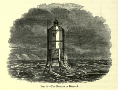
|
Temporary
living quarters on the Bell Rock while the lighthouse
was under construction. [p.343]
Picture: The Internet Text Archive. |
Mr. Rennie, accompanied by his son George, visited the rock on the
5th of October, 1807, the day before the works were suspended for
the winter. They came off from Arbroath, and stayed on board the
lighthouse yacht all night, where Mr. Stevenson states that he
"enjoyed much of Mr. Rennie's interesting conversation, both on
general topics and professionally upon the progress of the Bell Rock
works, on which he was consulted as chief engineer." On the
following morning Mr. Rennie landed to inspect the progress made in
the excavation, being received with a display of colours from the
beacon and three cheers from the workmen. They continued at work for
only about three hours that day, after which the whole working
party, accompanied by the chief engineer and his son, the resident
engineer, and the foreman of the works, returned to land for the
winter.
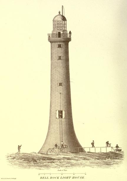
Picture: The Internet Text Archive.
The preparation of the stone blocks for next summer's operations
then proceeded on shore; and by the spring large numbers were
dressed, and ready to be floated off. In May, 1808, the excavations
on the rock were proceeded with, and on the l0th of July the first
stone was laid with considerable ceremony. Mr. Rennie paid his next
visit on the 25th of November following, for the purpose of
inspecting the work done, and reporting progress to the
Commissioners. From his report it appears that three courses of
masonry had by that time been laid in a very complete manner. At his
suggestion, a modification was adopted in the cement used for the
building, and also in the use of the granite blocks delivered from
the Aberdeen quarry, some of which had been found defective.
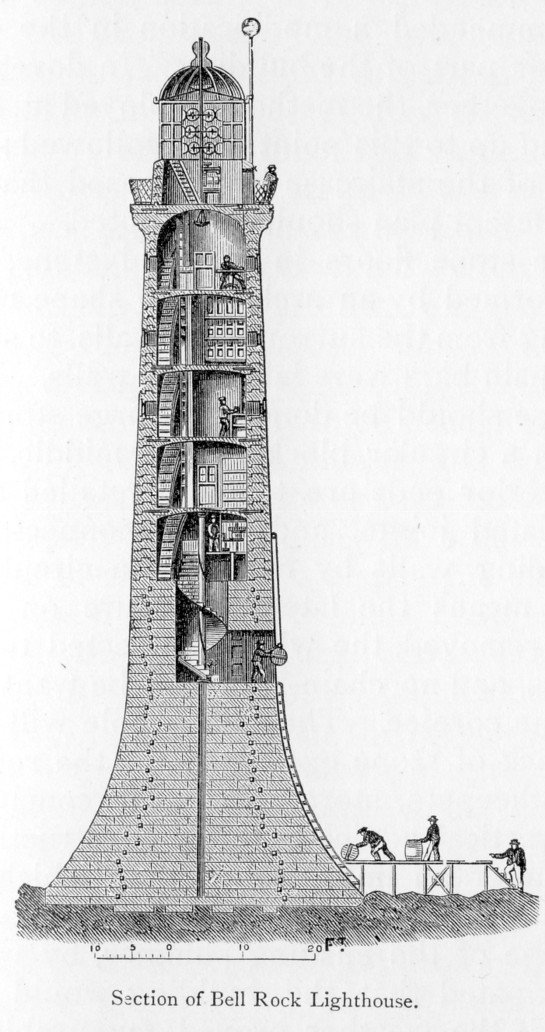
By the end of 1809, at our engineer's next visit of inspection, the
tower had been built to a height of 30 feet, and was comparatively
secure against the effects of the most violent seas. In his report
to the Commissioners he stated that he found that the form of slope
which he had adopted for the base of the tower, as well as the curve
of the building, fully answered his expectations—that they presented
comparatively small obstruction to the roll of the waves, which
played round the column with ease—and he expressed the opinion that
the lighthouse, when finished, "would be found to be the most
perfect work of its kind." In his report he recommended a
modification in the details of the upper part of the building. In
dovetailing the stones together, the method employed at the
Eddystone had up to this point been followed; but from the top of
the staircase he proposed that a somewhat different plan should be
adopted.
"The stone floors in the Eddystone," he said, "were formed by an
arch in the shape of a dome springing from the surrounding walls, to
strengthen which chain bars were laid in the walls. I propose that
these should be done with large stones radiating from a circular
block in the middle, to which their interior ends are to be
dovetailed as well as the radiated joints, and these connected to
the surrounding walls by means of a circular dowel. By this means
the lateral pressure on the walls will be removed, the whole
connected together as one mass, and no chain-bars will be wanted
except under the cornice. Thus the whole will be like a solid block
of stone excavated for the residence of the lightkeepers, stores,"
&c. He concluded with some practical advice as to the construction
of the lantern after an improved method which he proposed, in order
that it might be in readiness in the course of the ensuing summer,
by which time he anticipated that the building would be ready for
use if the weather proved favourable. These recommendations were
adopted, and the work having proceeded satisfactorily, the whole was
completed by the end of 1810, and the light was regularly exhibited
after the 1st of February, 1811.
When finished, the tower was 10 feet higher than the original
design, being 95½ feet to the top of the cornice, and 127 feet to
the top of the lantern. The additional height to which Mr. Rennie
thought it necessary to carry the lighthouse during its
construction, had the effect of raising the total cost to £61,331;
but he believed that the increased outlay would be fully justified
by the greater security of the lighthouse and its increased
efficiency for the purpose for which it was intended.
Notwithstanding the facts which we have stated, showing that Mr.
Rennie acted throughout as the chief engineer of the lighthouse—that
he furnished the design, arranged the details of the building,
settled the kind of materials to be used, down even to the mode of
mixing the mortar, and from time to time made various alterations
and modifications in the plans of the work during its progress, with
the sanction of the Commissioners—his name has not usually been
identified with the erection of the structure; the credit having
been almost exclusively given to Mr. Robert Stevenson, the resident
engineer,—arising, no doubt, from the circumstance of Mr. Rennie
being in a great measure ignored in the 'Account of the Bell Rock
Lighthouse,' published by Mr. Stevenson several years after the
death of Mr. Rennie.
The following account was given by Mr. Rennie himself, in a letter
to Matthew Boulton of Birmingham, [p.347]
relative to his own and Mr. Stevenson's connection with the plans
and erection of the lighthouse:—
"Mr. Robert Stevenson was bred a tinsmith and lamp-maker, in which
line he was employed by a Mr. Thomas Smith, a considerable
manufacturer in Edinburgh, who had the care of the reflectors and
lamps belonging to the Commissioners of Northern Lights. While in
Smith's employment Stevenson married his daughter, and Smith,
advancing in years, employed Stevenson to look after the Northern
Lights. This he did for several years. When Smith declined the
situation, Stevenson was elected in his place.
"When the Bell Rock Lighthouse was erected, Stevenson was employed
to superintend the whole. A regular head mason and carpenter were
employed under him. The original plans were made by me, and the work
was visited by me from time to time during its progress. When the
work was completed, Stevenson considered that he had acquired
sufficient knowledge to start as a civil engineer, and in that line
he has been most indefatigable in looking after employment, by
writing and applying wherever he thought there was a chance of
success.
"He has assumed the merit of applying coloured glass to lighthouses,
of which Huddart was the actual inventor, and I have no doubt that
he will also assume the whole merit of planning and erecting the
Bell Rock Lighthouse, if he has not already done so. I am told that
few weeks pass without a puff or two in his favour in the Edinburgh
papers" * * *
Mr. Stevenson was unquestionably entitled to great merit for the
able manner in which he performed his duties as a superintendent in
connection with the building of the Lighthouse. Mr. Rennie was
always ready to acknowledge this. But had any failure occurred in
consequence of a defect in the plans, Mr. Rennie, and not Mr.
Stevenson, would have been held responsible. As, however, the
Lighthouse proved a success, it is but fair that the chief engineer
should not be deprived of the merit which unquestionably belonged to
him. It is a matter of impossibility that engineers in extensive
practice should personally superintend the various structures
designed by them, and which are proceeding at the same time in
different parts of the country. Hence the appointment, at their
recommendation, of superintendents or resident engineers, whose
business it is to see that the details of the design are faithfully
carried out, and that the work is executed in all respects according
to the chief engineer's designs and instructions.
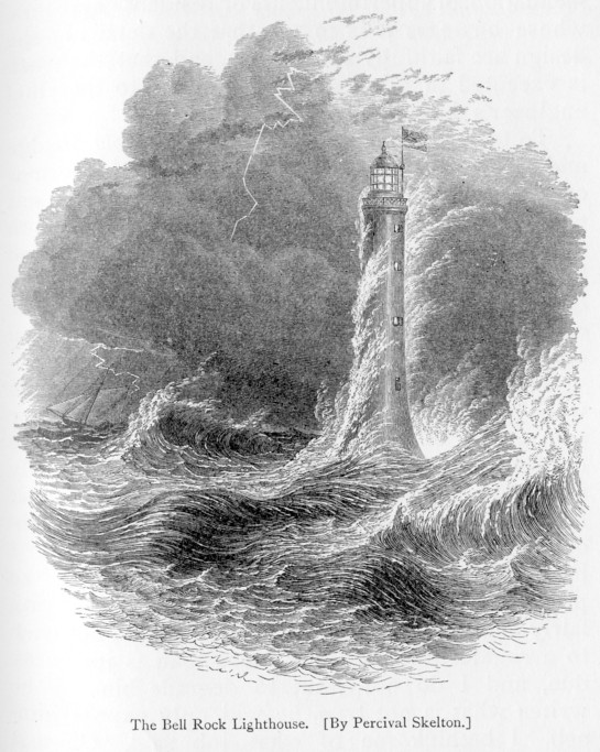
To take two instances—Telford's Menai Bridge and Stevenson's
Britannia Bridge—in the former of which cases Mr. Provis was
appointed resident engineer, and in the latter Mr. Edwin Clarke. Both of these gentlemen afterwards published detailed histories of
these works; but neither of them ignored the chief engineer, nor did
they claim the exclusive merit of having been the successful
erectors of these magnificent structures.
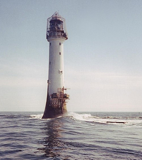
Bell Rock Lighthouse. Picture Wikipedia (Derek
Robertson mod. cactus.man). [p.350]
During Mr. Rennie's lifetime various notices were published,
claiming for Mr. Stevenson the sole credit of having designed and
erected the lighthouse. At this Mr. Rennie was naturally annoyed;
and the more so when he learnt that Mr. Stevenson was about to
"write a book" without communicating with him on the subject. "I
have no wish," he says, in a letter to a friend, "to prevent his
writing a book. If he details the truth fairly and impartially, I am
satisfied. I do not wish to arrogate to myself any more than is
justly my due, and I do not want to degrade him. If he writes what
is not true, he will only expose himself. I bethink me of what Job
said, 'Oh that mine enemy would write a book!'" The volume, however,
was not published till three years after Rennie's death; and it was
not until the publication of Sir John's work on Breakwaters, that
his father's claims as chief and responsible engineer of the
lighthouse were fairly asserted and afterwards fully and clearly
established. [p.351]
――――♦―――― |
[Next Page] |