|
[Previous
Page]
Footnotes.
|
p.218 |
G. Buchan Hepburn's 'General View of the Agriculture
and Economy of East Lothian, 1794,' p.151. |
|
p.219-1 |
Dr. Carlyle, 'Autobiography,' p.326. |
|
p.219-2 |
Ibid. 303. |
|
p.220 |
There is every reason to believe that at a remote
period, Scotland had been well cultivated. The army of Edward
I. subsisted on the beans and pease which they found in the field,
when besieging Dirleton, East Lothian, in 1298; and from the old
chartularies of the Monastic establishments, it is clear that wheat
was cultivated to a considerable extent, at the same time.
Adda, mother of William the Lion, having founded a nunnery at the
Abbey, near Haddington, about the year 1178, endowed it with the
rents of certain lands in the neighbourhood. The rents were
paid in kind for the maintenance of the nuns, and consisted, amongst
other things, of four bolls of wheat and three bolls of oatmeal
yearly. And yet, at the beginning of the eighteenth century,
the production of wheat in Scotland had been entirely discontinued. |
|
p.221 |
Among these were Fletcher of Saltoun, the Earl of
Wigton, and others. For further remarks as to the decayed
state of Scotland at this time, see vol. iii. 'History of Roads,'
pp. 48-59. |
|
p.223 |
Appendix to 'Picture of Dumfries.' By John
MacDiarmid. Edinburgh, 1832. |
|
p.224 |
'Farmer's Magazine,' No. xxxiv., p.199. |
|
p.226 |
Besides the abundance of schools, and the excellence
of the education given, the moderation of the fees charged is worthy
of notice. Dr. Guthrie, in his 'Autobiography,' mentions the
schools at Brechin, where he was educated some sixty years ago.
First, he was taught at a private school, of which the late Dr.
McCrie was the teacher. "Besides this school," he says, "there
were two others in Brechin where Latin and Greek, French and
Mathematics, were taught. One of these was endowed from
property belonging in Roman Catholic times to the Knights Templars,
who had a preceptory there. The other was the parish school.
Both were conducted by 'preachers,' or licentiates of the Church of
Scotland—university men who had spent at least eight years at
college. Both prepared young men for the university, teaching
them, besides the more common branches of education, Algebra,
Euclid, French, Latin, Greek, and all for five shillings a quarter!
That may astonish people now-a-days. But so it was; and the
bursaries which a large proportion of these pupils won by open
competition at the universities of St. Andrews and Aberdeen, while
the means of their support there, proved the goodness of the
teaching they got for this small sum. The result of this cheap
and efficient education was that the sons of many poor and humble
people pulled their way up to honourable positions in life, while
the parents had not their self-respect and feelings of independence
lowered by owing the superior education of their children to others
than themselves." ('Autobiography,' pp. 33-34.) |
|
p.227 |
A writer, in the Scotch Farmer's Magazine for
1810, makes the following observations:—"During the last fifty years
Scotland has made rapid progress in agriculture, architecture,
navigation, and commerce; and if in some she has excelled her
neighbours, it may perhaps be ascribed to that wholesome and useful
system of parochial education, which was bequeathed to her children
by the last Parliament which she ever assembled as an independent
kingdom. The elements of learning, consisting of reading,
writing, and accounts, though seemingly superficial attainments,
have nevertheless, been of immense value to the people. They
have enabled them to comprehend, adopt, and improve to the utmost,
every new branch of science, as soon as it sprung up in any corner
of Europe: and there is no circumstance so peculiar in the
possession of a little knowledge, as the desire which it
communicates, and the capacity which it bestows, of obtaining still
more." |
|
p.228 |
Amongst George Rennie's illustrious visitors in his
later years was the Grand Duke Nicholas (afterwards Emperor) of
Russia, who stayed several nights at Phantassie, and during the time
was present at the celebration of a "hind's wedding." |
|
p.233 |
'Essays on the Trade, Commerce, Manufactures, and
Fisheries of Scotland.' |
|
p.236 |
It would seem that the ancestors of Meikle were held
in esteem as ingenious workmen for generations; the Scots Parliament
having, in 1686, passed a special Act for the encouragement of John
Meikle, founder, who, it appears was the first person to introduce
the art of iron-founding into Scotland. |
|
p.239-1 |
The Marquis of Tweeddale introduced the turnip into
the county in 1740; the Earl of Haddington and Mr. Walker of
Beanston, first adopted the system of fallowing land and sowing
broad clover and rye-grass. Lord Eubank and Sir Hew
Dalrymple divided between them the merit of inventing or introducing
the practice of under-draining; and Sir George Suttie first employed
the Norfolk system of rotation of crops. |
|
p.239-2 |
Brown on 'Rural Affairs.' |
|
p.240 |
See Adam Smith's 'Wealth of Nations,' Book II., Chap.
2. |
|
p.241 |
Patent No. 896. The name of Robert Mackell
(employed with James Watt in the survey of the "ditch canal" through
Perthshire—see Life of Smeaton) was associated with that of Meikle
in this patent; Mackell probably finding the money, and Meikle the
brains. |
|
p.242 |
Afterwards Sir Francis Kinloch. |
|
p.243 |
The following is a literal copy of the memorandum
which was drawn up and signed on the occasion:—
"Know Mill, 14th Feb., 1778.—We whose names are subjoined, desired
by Andrew Meikle to witness an experiment of his threshing machine,
mett this day, and after one hour's performance of said machine,
with the assistance of one man to feed in and carry of the straw,
dight and measured up one boll, and two forpets barley being of meen
qualitie, We are of opinion that a Man, in the ordinary way of
threshing, could not threshed abuve five, or 6 firlots at most, in
one day. The machine being simple, we suppose one horse may
worke it without an aditional man. The saving most be
considerable.
|
"(Signed)
John Dudgeon,
Tenent in Tyningham
Robert Dick,
Tenent in Hedderwik,
George
Rennie, Tenent in Fantase,
William
Wilson, Tenant in Peastown
William
Craig, Tyningham." |
|
|
p.244 |
'A Reply to an Address to the Public, but more
particularly to the Landed Interest of Great Britain and Ireland, on
the subject of the Threshing Machine.' By John Sheriff.
Edinburgh 1811. |
|
p.246 |
Patent No. 1645: "Machine for separating Corn from
Straw." |
|
p.247 |
'Memoirs of Sir John Sinclair,' vol. ii. p.99. |
|
p.251 |
It is remarkable that Scotch biography should be
altogether silent respecting this ingenious and useful workman.
In the most elaborate of the Scotch biographical collections—that of
Robert Chambers, in four large volumes—not a word occurs relating to
Meikle. An article is devoted to Mickle, the translator of
another man's invention in the shape of a poem, the 'Lusiad;' but
the name of the inventor of the thrashing-machine is not even
mentioned; affording a singular illustration of the neglect which
this department of biography has heretofore experienced, though it
has been by men such as Meikle, and not by poets, that this country
has in a great measure been made what it is. |
|
p.264 |
In the interval between 1784 and 1792, not fewer than
302 Acts were passed authorising the construction of new roads and
bridges, 64 authorising the formation of canals and harbours, and
still more numerous Acts for carrying out measures of drainage,
enclosure, paving, and other local improvements—a sufficient
indication of the industrial activity of the nation at that time. |
|
p.269 |
Shortly after the completion of these mills, Mr.
Rennie was largely consulted on the subject of machinery of all
kinds. The Corporations of London, Edinburgh, Glasgow, Perth,
and other places, took his advice as to flour-mills.
Agriculturists consulted him about thrashing-mills, millers about
grinding-mills, and manufacturers and distillers respecting the
better arrangement of their works. In July, 1798, he was
called upon to examine the machinery and arrangements at the Royal
Mint on Tower Hill. The result was, the construction of an
entire new mint, worked by steam-power, with improved rolling,
cutting out, and stamping machinery, after Mr. Rennie's designs.
The new machinery was introduced between the years 1806 and 1810.
The cutting-out and stamping-machines were the invention of the late
Matthew Boulton, of Soho, but the machinery was by Rennie. On
one occasion, in 1819, a million of sovereigns was turned out in
eight days! During the great silver coinage in 1826, the eight
presses turned out, for nine months, not less than 247,696 pieces
per day, the rolling going on day and night, and the stamping for
fifteen hours out of every twenty-four. Mr. Rennie also
supplied the machinery for the mints at Calcutta and Bombay; that
erected at the former place being capable of turning out 200,000
pieces of silver in every eight hours. |
|
p.272-1 |
His first place of business was at Old Jamaica Wharf,
Upper Ground Street, Lambeth. |
|
p.272-2 |
Ed.—Charles Stanhope, 3rd Earl Stanhope, F.R.S.
(1753-1816) was a British statesman, scientist and inventor, among
his inventions being the printing press (ca. 1800) which bears his
name. In it, Stanhope retained the conventional screw for
applying pressure to the work, but separated it from the spindle and
bar, inserting a system of compound levers between them. The effect
of several levers acting upon each other was to increase
considerably the power applied resulting in sharper impressions. |
|
p.273 |
He adopted paddles, placed under the quarters of the
vessel, which were made to open and shut like the feet of a duck. |
|
p.274 |
Ed.—The Kennet & Avon Canal was opened between Newbury and Bath
in 1810 but (in common with many other British canals) the coming of
railways—in this case the opening of the Great Western Railway in
1841—removed much of the traffic and the canal went into decline,
falling into
disuse in the 1950s when a stoppage at Burghfield made it impassable
and large sections of the canal were closed due of poor lock
maintenance. However, in 1956 The
Kennet and Avon Canal Trust successfully petitioned against its
legal closure and, following the formation of the British
Waterways Board in 1963, restoration work commenced. The fully
restored canal (the first to be grade I listed) was
re-opened by HM The Queen on 8 August 1990.
The complete navigation runs from High Bridge, Reading, where it joins the River Thames, to
the floating harbour at Bristol. The original Kennet
and Avon Canal linked the River Kennet at Newbury to the
River Avon at Bath (57 miles); however, the "navigation" extends between the
River Thames at Reading and the Floating Harbour at Bristol (87
miles) using
the earlier improved river navigations of the River Kennet, between
Reading and Newbury, and River Avon between Bath and Bristol. |
|
p.276 |
Ed.—Rennie's Avoncliffe Aqueduct was opened
1801. It comprises three arches, and is 110 yards long. Its central
elliptical arch is of 60 ft span with two side arches each
semicircular and of 34 ft span, all with V-jointed arch stones. The
spandrel and wing walls are built in alternate courses of ashlar
masonry, and rock-faced blocks. Throughout its life the central span
gave structural problems and has been repaired many times. |
|
p.281-1 |
The following canal works of Mr. Rennie may be
mentioned—The Aberdeen and Inverurie, 12 miles long, laid out and
constructed by him in 1796-7; the Calder Reservoirs and improvement
of the Trent and Mersey Canal at Rudyard Valley, near Leek, 1797-8;
a branch of the Grand Trunk Canal to Henley, with a railway
connecting it with the manufactories. He also made elaborate
reports on the Leominster Canal (1798); on the Chelmer and
Blackwater Navigation; Somersetshire and Dorsetshire Canal;
Horncastle Navigation; River Foss Navigation; Polbrook Canal (1799);
Rotherhithe and Croydon; Thames and Medway (1800); and River Lea
Navigation (1804). Among the works surveyed by him, but which
were not carried out, were these: a canal through the Weald of Kent
(1802-3); a ship-canal between the Thames and Portsmouth (1803); a
ship canal between the Medway and Portsmouth (1810); a ship-canal
from Chichester Harbour to Chichester (1804); and a ship-canal from
Bristol to the English Channel (1811). He was also employed by
the Gloucester and Berkeley Canal Company, the Birmingham Canal
Company, and the Leeds and Liverpool Canal Company, as their
consulting engineer; and various important improvements in these
navigations were carried out by his advice and under his
superintendence. |
|
p.281-2 |
Ed.―the Lune Aqueduct, completed in 1797,
carries the Lancaster Canal over the River Lune to the east of the
City of Lancaster. One of Rennie's finest works, the aqueduct is
classical in style with rusticated masonry and curved wingwalls, and
is over 600ft long—unsurprisingly it has a Grade I preservation listing.
But Smiles fails to mention that the Canal had an unfortunate
history, which can be attributed to the Lune Aqueduct..
Rennie surveyed a route from Wigan
and Preston to Kendal, during 1791, mapping out a fine example of a
'contour' canal (one that follows the lie of the land and does not
need locks). Construction
of the Lune Aqueduct was commenced in 1794 ahead of the building of
the canal that connected to it. But at £48K its construction proved so expensive that there was no money left to build the
matching aqueduct over the
River Ribble at Preston necessary to connect to the national canal network. Thus the Lancaster Canal remained in
splendid isolation for over 200 years. It did, however, provide a
waterway between Preston and Tewitfield, which was later extended
north to Kendal (1819), while a short branch to Glasson Dock was
opened (1826) to carry the canal down to the sea via a flight of
locks.
Declining traffic during the 1950s led to the Canal being partly abandoned.
Today only
the section from Preston to Tewitfield near Carnforth—42 of the
original 57 miles north of Preston—is open to navigation, the route north of Tewitfield having been severed by
the M6 Motorway and, in places, filled in. However, in 2002 a link was
opened to connect the previously isolated Canal to the rest of the national network via a canalisation of the Savick Brook. The new link skirts the outskirts of Preston and flows
into the River Ribble. From there it uses the River Douglas to
connect to the national network via the Leeds and Liverpool Canal's
Rufford Branch. |
|
p.285 |
'Journal of Royal Agricultural Society,' 1847, vol.
viii. p.124. |
|
p.287 |
A writer in an old number of the 'Universal Magazine'
(published in 1773) describes a conversation with a
cadaverous-looking man whom he encountered in the Fens, and condoled
with on his forlorn and meagre appearance. The man rejoined,
that he had never been better since he had buried the first of his
nine wives. "Nine wives?" "Yes, nine wives!" was the
reply. The man explained that the Fen men were accustomed to
seek their wives in the upland country, selecting those who had a
little money; and as living in the Fens was certain death to
strangers during the fever season, many of the Fen men thus
contrived to accumulate a good deal of money. But the Fen
districts have long since ceased to possess this peculiar advantage,
for they are now as healthy as the upland districts themselves. |
|
p.294 |
Report, dated the 7th of April, 1800. |
|
p.296-1 |
See the Map in vol. i. of the 'Fens as Drained in
1830;' p.51. |
|
p.296-2 |
Ed.—the Witham Navigable Drains are located in
Lincolnshire, and are part of a much larger drainage system managed
by the Witham Fourth District Internal Drainage Board. In
total there are over 438 miles of drainage ditches, of which under
60 miles are navigable. Navigation is normally only possible
in the summer months, as the drains are maintained at a lower level
in winter, and are subject to sudden changes in level as a result of
their primary drainage function, which can leave boats stranded.
Access to the drains is from the River Witham at Anton's Gowt Lock. |
|
p.297 |
The following letter, written by a Lincolnshire
gentleman, in January, 1807, appears in the 'Farmer's Magazine' of
February in that year:—"Our fine drainage works begin now to show
themselves, and in the end will do great credit to Mr. Rennie, the
engineer, as being the most complete drainage that ever was made in
Lincolnshire, and perhaps in England. I have been a
commissioner in many drainages, but the proprietors never would
suffer us to raise money sufficient to dig deep enough through the
old enclosures into the sea before; and, notwithstanding the
excellency of Mr. Rennie's plan, we have a party of uninformed
people, headed by a little parson and magistrate, who keep
publishing letters in the newspapers to stop the work, and have
actually petitioned Sir Joseph Banks, the lord of the manor, against
it; but he answered them with a refusal, in a most excellent way . .
. . I think Mr. Rennie's great work will promote another general
improvement here, which is, to deepen and enlarge the river Witham
from the sea, through Boston and Lincoln to the Trent, so as to
admit of a communication for large vessels, as well as laying the
water so much below the surface of the land as to do away with the
engines. We have got an estimate, and find the cost may be
about £100,000." |
|
p.299 |
Mr. Bower's estimate was as follows:—
 |
|
p.300 |
In his admirable Report dated the 6th October, 1800,
Mr. Rennie pointed out that the lines of direction in which the
rivers Welland and Witham entered the Wash tended to the silting-up
of the channels of both, and he suggested that the two river outlets
should be united in one, and diverted into the centre of the Wash,
at Clayhole, which would at the same time greatly increase the
depth, and enable a large area of valuable land to be reclaimed for
agricultural purposes. This suggestion has since been
elaborated by Sir John Rennie*, whose plan of 1837, when fully
carried out, will have the effect of greatly improving the outfalls
of all the rivers entering the great Wash—the Ouse, the Nene, the
Welland, and the Witham—and the drainage of the low level lands
depending upon them, comprising above a million of acres, and
ultimately gaining from the Wash between 150,000 and 200,000 acres
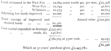
of rich new land, or equal to the area of a good-sized county. In
the Wash of the Nene, called Sutton Wash, 4000 acres have already
been reclaimed after this plan—the land, formerly washed by the sea
at every tide, being now covered with rich cornfields and
comfortable farmsteads. It was at this point that King John's
army was nearly destroyed when crossing the sands before the
advancing tide.
* Ed.—Sir John Rennie (1794-1874) was the
second son of engineer John Rennie and brother of George Rennie. |
|
p.301 |
Among other important works of the same kind executed
by Mr. Rennie, but which it would be tedious to describe in detail,
was the reclamation (in 1807) of 23,000 acres of fertile land in the
district of Holderness, near Hull. He was extensively employed
to embank lands exposed to the sea, and succeeded (in 1812) in
effectually protecting the thirty miles of coast extending from
Wainfleet to Boston, and thence to the mouths of the rivers Welland
and Glen. Two ears later (in 1814) he, in like manner,
furnished a plan, which was carried out, for protecting the Earl of
Lonsdale's valuable marsh land on the south shore of the Solway
Frith. |
|
p.305 |
Thompson's 'History of Boston,' 1856, p. 639. |
|
p.308 |
Dr. Robison was the first contributor to the 'Encyclopedia'
who was really a man of science, and whose articles were above the
rank of mere compilations. He sought information from all
quarters—searched the works of foreign writers, and consulted men of
practical eminence, such as Rennie, to whom he could obtain
access—and hence an extraordinary value was imparted to his
articles. |
|
p.312 |
The great arch of 450 feet was to be supported on two
stone piers, each 75 feet thick, the springing to be 100 feet above
high water. There were to be arches of stone on the Caernarvon
side to the distance of about 156 yards, and on the Anglesea side to
the distance of about 284 yards, making the total length of the
bridge, exclusive of the wing walls, about 640 yards. The
estimated cost of the whole work and approaches was £268,500.
The point at which the bridge was recommended to be thrown across
was, either opposite Inys-y-Moch island, on which one of the main
piers would rest, or at the Swilly rocks, about 800 yards to the
eastward; but, on the whole, he preferred the latter site. He
also sent in a subsequent design, showing an iron arch on each side
of the main one of 350 feet span, in lieu of masonry, with other
modifications, by which the dimensions of the main piers were
reduced, and the estimate somewhat lessened. Other plans were
prepared and submitted, embodying somewhat similar views, the
prominent idea in all of them being the spanning of the Straits by a
great cast-iron arch, the crown of which was to be 150 feet above
the sea at high water. The plans and evidence on the subject
are to be found set forth in the 'Reports from Committees of the
House of Commons on Holyhead Roads' (1810-22), ordered to be printed
25th July, 1822. |
|
p.313 |
John Rennie designed Boston's first "Town Bridge", in
one arch of cast iron of 86 feet span. The bridge was
"re-built" in 1913 to a design by John Webster—I've been unable to
discover why. |
|
p.314 |
Among his minor works may be mentioned the bridge
over the stream which issues out of Virginia Water and crosses the
Great Western Road (erected in 1805); Darlaston Bridge across the
Trent, in Staffordshire (1805); the timber and iron bridge over the
estuary of the Welland at Fossdyke Wash, about nine miles below
Spalding (1810); the granite bridge of three arches at New Galloway,
on the line of the Dumfries and Portpatrick Road (1811); a bridge of
five arches across the Cree at Newton Stewart (1812); the cast-iron
bridge over the Goomtee at Lucknow, erected after his designs in
1814, and frequently referred to in the military operations for the
relief of that city a few years ago; Wellington Bridge, over the
Aire, at Leeds (1817); Isleworth Bridge (1819); a bridge of three
elliptical arches of 75 feet span each, at Bridge of tarn,
Perthshire (1819); Cramond Bridge, of eight semicircular arches of
50 feet span, with the roadway 42 feet above the river (1819); and
Ken Bridge, New Galloway, of five stone arches, the centre go feet
span (1820). An adventure of some peril attended Mr. Rennie's
erection of the bridge at Newton Stewart. He happened to visit
the works on one occasion during a heavy flood, which swept down the
valley with great fury; and the passage of the ferry was thus
completely interrupted. Mr. Rennie and his son (the present
Sir John) were consequently unable to cross over to Newton Stewart.
About 11 p.m. the violence of the storm had somewhat abated, and the
moon came out, though obscured by the clouds which drifted across
her face. Mr. Rennie went out at that late hour to look at the
bridge works, and even to try whether he might not reach the other
side by crossing the timber platform by means of which the works
were being carried on. There was a gangway of only two planks
from pier to pier on the eastern side, and this he safely crossed.
The torrent was still raging furiously beneath, shaking the frail
timbers of the scaffolding. As Mr. Rennie was about to place
his foot on the plank which led to the third pier, his son observed
the framework tremble, and pulled his father back, just in time to
see the whole swept into the stream with a tremendous crash.
Fortunately the planking still stood across which they had passed,
and they succeeded in retracing their steps in safety. The
bridge was finished and opened during the summer of 1814. |
|
p.316 |
In their report on this design, Mr. Rennie and his
colleague observed:—"We should not have thought it necessary to
quote the production of a foreign country for the sake of showing
the practicability of constructing arches of 130 feet span, had we
not been led to it by the exact similarity of the designs, and by
the principle which is therein adopted of the compound curve;
because our own country affords examples of greater boldness in the
construction of arches than that of Neuilly. There is a bridge
over the river Taff, in the county of Glamorgan, of upwards of 135
feet span, with a rise not exceeding 32 feet, and what is more
remarkable is, that the depth of the arch-stones is only 30 inches;
so that in fact that bridge far exceeds in boldness of design that
of Neuilly." [See the Memoir of William Edwards at p. 86.]
After some observations as to the importance and necessity of making
a bridge in such a situation at the bend of the river, with as large
arches as possible, to accommodate the navigation and present as
little obstruction as possible to the rise and fall of the water,
they proceeded:—"We confess we do not wholly approve of M.
Peyronnet's construction as adapted for the intended situation.
It is complicated in its form, and, we think, wanting in effect.
The equilibrium of the arches has not been sufficiently attended to;
for when the centres of the bridge at Neuilly were struck, the top
of the arches sank to a degree far beyond anything that has come to
our knowledge, whilst the haunches retired or rose up, so that the
bridge as it now stands is very different in form from what it was
originally designed. No such change of shape took place in the
bridge over the Taff (Pont-y-Prydd); the sinking after the centres
were struck did not amount to one-half of that at Neuilly, although
the one was designed and built under the direction of the first
engineer of France, without regard to expense, whilst the other was
designed and built by a country mason with parsimonious economy.
Our opinion therefore is, that the arches of the bridge over the
Thames should either be plain ellipses, without the slanting off in
the haunches so as to deceive the eye by an apparent flatness which
does not in reality exist, or they should be of a flat segment of a
circle formed in such a manner as to give the requisite room for the
passage of the current and barges under it." |
|
p.317 |
In June, 1810, we find him accepting the direction of
the new bridge at £1,000 a-year for himself and assistants, or £7
7s. a-day and expenses; but on no account were any of his people to
have to do with the payment or receipt of moneys. |
|
p.320 |
The coffer-dams in which the foundations of the
abutments were built, were formed by driving two rows of piles 13 by
6½ inches each, with a counter or abutting pile at every 12 feet 12
by 12, driven in the form of an ellipsis, and strongly cemented
together, at low-water and high-water levels, by double horizontal
walings or bracks, having a space of about 8 inches clear between
them for the intermediate or half piles. The whole were driven
close together from 15 to 20 feet deep into the ground, well
caulked, so as to be water-tight, and all connected firmly together
by strong wrought iron bars and bolts, besides shores and
intermediate braces. The spaces between the two rows of piles
were then rammed close with well-tempered clay, so that they formed,
as it were, a solid vat or tub impermeable to water; and within
these, when pumped clear of water, the excavation was made to the
proper depth, and in the space so dug out the building operations
proceeded. The cofferdams for the piers were formed in a
similar manner, with modifications according to circumstances.
By this means the bed of the river, where the piers were to be
erected, was exposed and dug out to the proper depth, and the
foundations were commenced from a level nine feet at least below
low-water mark. The foundations there rested upon timber piles
from 20 to 22 feet long, driven into the solid bed of the river.
Upon the heads of these piles half-timber planking was spiked, and
on this the solid masonry was built—every stone being fitted,
mortared, and laid with studious accuracy and precision. The
whole work was done with such solidity that, after the lapse of
fifty years, the foundations have not yielded by a straw's breadth
at any point. |
|
p.326 |
Ed.—Rennie's bridge was indeed "a noble work",
its elegant style blending comfortably with that of the adjacent
Somerset House. The Italian sculptor Canova described it as
“the finest bridge in all Europe”—but Smiles's prediction that it
was "built for posterity" was not to be. From the
early 1880's serious problems were found in the bridge's piers
caused by scour from the increased river flow following the removal
of the old London Bridge (ironically, to be replaced by a bridge
designed by Rennie). By the 1920s the problems had become serious.
Heavy superstructure was removed and temporary reinforcements put in
place, but the remedy proved unsuccessful and the bridge was closed
to traffic in 1924. After much debate it was decided eventually to
replace Rennie's bridge with the functional but austere
Portland stone-clad structure (completed in 1945 to a design by Sir
Giles Gilbert Scott) which stands today.
Rennie's Waterloo Bridge was built for the 'Strand Bridge
Company'. Opened in 1817 as a toll bridge, the toll was
removed in 1878 when the bridge was taken over by the Metropolitan
Board of Works. Despite the toll, it soon gained a reputation
as a popular jump for suicides, as is depicted in
Thomas Hood's famous poem, "The
Bridge of Sighs" (illustrated below by Gustav Doré) . . . .
 |
|
p.334 |
Article on Iron Bridges in 'Encyclopedia Britannica.'
Ed.—Rennie’s Southwark Bridge was said to be
‘unrivalled as regards its colossal proportions, its architectural
effects and the general simplicity and massive character of its
details’. Alas, as with his two other great Thames bridges,
Rennie's Southwark Bridge was not to be, as Smiles's put it (with
regard to Waterloo Bridge),"built for posterity". An increase
in traffic followed the removal of the tolls in 1868, to the extent
that by the end of the 19th century it had become apparent that
Rennie's bridge was too narrow to cope with the volume, and that a
broader bridge with better approach roads was needed.
Demolition of Rennie's fine bridge began in 1913, but with World War
I intervening the existing bridge was not completed until 1921. |
|
p.335 |
The following is the tradition as given by an old
writer:—"By the east of the Isle of May, twelve miles from all land
in the German Sea, lyes a great hidden rock called Inchcape, very
dangerous to the navigators, because it is overflowed every tide.
It is reported that, in old times, there was upon the said rock a
bell, fixed upon a tree or timber, which rang continually, being
moved by the sea, giving notice to the saylors of the danger.
This bell or clocke was put there by the Abbot of Aberbrothock, and,
being taken down by a sea-pirate, a yeare thereafter he perished
upon the same rock, with ship and goodes, by the righteous judgment
of God." (Stoddart's 'Remarks on Scotland.') |
|
p.337 |
'Fragments of Voyages and Travels,' i. 15-16.
Edinburgh, 1831. |
|
p.338 |
Baron Dupin in his 'Commercial Power of Great
Britain,' says:—"Several engineers submitted plans; but, by the
advice of Mr. Rennie, the model and dimensions of the Eddystone
Lighthouse were adopted with the improvements in lighting, which the
recent progress in optics allowed him to make." (ii. 159.) |
|
p.341 |
A detailed account of the operations was afterwards
published by the assistant-engineer, in his interesting work
entitled 'An Account of the Bell Rock Lighthouse.' By Robert
Stevenson, Civil Engineer. Edinburgh, 1824. |
|
p.343 |
Ed.—"So soon as a barrack of timber-work could
be erected on the rock as a substitute for the floating light, it
was inhabited by Mr. Stevenson and twenty-eight men. This
barrack was a singular habitation, perched on a strong framework of
timber, carefully designed with a view to strength, and no less
carefully put together in its place, and fixed to the rock with
every appliance necessary to secure stability. The tide rose
sixteen feet on it in calm weather, and in heavy seas it was exposed
to the assault of every wave." (Life of Robert Stevenson, Civil
Engineer, by David Stevenson. Adam and Charles Black,
Edinburgh, 1878.) |
|
p.347 |
Letter dated the 12th March, 1814. Boulton MSS. |
|
p.350 |
Ed.—the Bell Rock Lighthouse is maintained by
the Northern Lighthouse Board
who publish the following details:—
|
Light Established: 1811.
Engineer: Robert Stevenson.
Position: Latitude 56° 26.1’N; Longitude 02° 23.1’W.
Situated: 12 Miles from Arbroath.
Character: Flashing White every 5 secs.
Elevation: 28 metres.
Nominal Range: 18 miles.
Structure: White tower 36 metres high. |
|
|
p.351 |
The correspondence which took place on the subject
will be found recorded in the 'Civil Engineer and Architect's
Journal,' Vol. xii., 1849.
Ed.—controversy continues to surround the question of who
should be
credited with the design of this
fine (and the world's oldest water-washed) lighthouse. It's interesting
to note that the Northern Lighthouse Board
website makes no mention of Rennie's contribution, while in the
episode featuring the Bell Rock Lighthouse in the BBC Television
docudrama series, "Seven Wonders of the Industrial World", his role
in its construction (and rather at variance with his track record)
is portrayed as one of meddling
interference. However, while Stevenson undoubtedly carried the
weight of the engineering and much of the lighthouse's design, the
evidence suggests that fellow Scot
Rennie's prudent design decisions —which Stevenson saw fit to
accept—ensured that the Bell Rock's basic structure conformed closely with Smeaton's
time-proven concepts for the Eddystone.
Robert Stevenson F.R.S.E. (1772-1850)—not to be confused with
Robert
Stephenson—became a notable civil engineer specialising in
lighthouse construction but also undertaking a range of other civil engineering
projects (see . . . Robert Stevenson, Civil Engineer,
by David Stevenson, pub. Adam and Charles Black, Edinburgh, 1878, a
copy of which is available online at
The Internet Text Archive. |
|
p.352 |
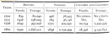
The increase in the trade of London is exhibited by
the following abstract of vessels entered at the port at different
periods since the beginning of last century:—
 |
|
p.356-1 |
2 George I I I., cap. 28. |
|
p.356-2 |
P. Colquhoun, LL.D., 'Treatise on the Police of the
Metropolis.' [6th Ed., 237.] |
|
p.358 |
Mr. Jessop was among the most eminent engineers of
his day. His father was engaged under Smeaton in the building
of the Eddystone Lighthouse; and, dying in 1761, he left the
guardianship of his family to Mr. Smeaton, who adopted William as
his pupil, and carefully brought him up to the same profession.
Jessop continued with Smeaton for about ten years; and, after
leaving him, he was engaged successively on the Aire and Calder, the
Calder and Hebble, and the Trent Navigations. He also executed
the Cromford and the Nottingham Canals; the Loughborough and
Leicester, and the Horncastle Navigations; but the most extensive
and important of his works of this kind was the Grand Junction
Canal, by which the whole of the north-western inland navigation of
the kingdom was brought into direct connection with the metropolis.
He was also employed as engineer for the Caledonian Canal, in which
he was succeeded by Telford, who carried out the work. Mr.
Jessop was the engineer of the West India Docks (1800-2), and of the
Bristol Docks (1803-8), both works of great importance. He was
the first engineer employed to lay out and construct railroads, as a
branch of his profession; the Croydon and Merstham Railroad, worked
by donkeys and mules, having been constructed by him as early as
1803. He also laid down short railways in connection with his
canals in Derbyshire, Yorkshire, and Nottinghamshire. During the
later years of his life he was much afflicted by paralysis, and died
in 1814. |
|
p.361 |
For further particulars as to these docks see Sir
John Rennie's 'British and Foreign Harbours.' Art. "London Docks." |
|
p.363 |
Among the improvements adopted by Mr. Rennie in these
docks may be mentioned the employment of cast iron, then an
altogether novel expedient, for the roofing of the sheds. One
of these, erected by him in 1813, was 1300 feet long and 29 feet 6
inches in span, supported on cast-iron columns 71 inches in diameter
at bottom and 53/4 at top. Another, still more capacious, of
54 feet clear span between the supports, was erected by him over the
mahogany warehouses in 1817. He also introduced an entirely
new description of iron cranes, first employing wheelwork in
connection with them, by which they worked much more easily and at a
great increase of power. He entirely re-arranged the working
of the mahogany sheds, greatly to the despatch of business and the
economy of labour. His quick observation enabled him to point
out new and improved methods of despatching work, even to those who
were daily occupied in the docks, but whose eyes had probably become
familiar with hurry scurry and confusion. |
|
p.366 |
The Prince's Dock at Liverpool was constructed after
Mr. Rennie's plans; but the greater part of the dock accommodation
at that port was provided under the direction of the late Mr. Jesse
Hartley. Mr. Hartley was a native of the North Riding of
Yorkshire, where his father held the position of Bridgemaster; and
his son, after receiving an ordinary education, served his
apprenticeship as a stonemason, and worked at the building of
Boroughbridge. Subsequently, he succeeded his father as
Bridgemaster, which he continued to retain, until his removal to
Liverpool, when he received the appointment of engineer to the Dock
Committee. During the period in which he held the office of
dock engineer, Mr. Hartley altered or entirely constructed every
dock belonging to the town. He was also engineer to the Bolton
and Manchester Railway and Canal, and consulting engineer for the
Dee Bridge at Chester, the centering for which was considered a
triumph of engineering skill and ability. |
|
p.367 |
See Sir John Rennie's 'British and Foreign Harbours;'
Art, "Aberdeen." |
|
p.368 |
Mr. Rennie proposed to form two docks on the
Broomielaw side of the river—one 1350 feet long and 160 feet wide,
with two entrances, and another 900 feet long and 200 feet wide;
with a third dock upon the Windmill Croft, on the south side of the
river, 300 feet long and 200 feet wide; the whole presenting a total
length of quayage of 6120 feet, besides a river quay wall 1150 feet
long. This magnificent plan, proposed more than half a century
since, viewed by the experience of this day, shows how clearly
Rennie anticipated the commercial growth and manufacturing
prosperity of Glasgow, for which these projected docks would have
afforded ample accommodation, at an estimated capital cost (at the
time the plans were made) of only £130,000. What would
not Glasgow give now to have the benefit of Rennie's docks?
Indeed it is remarkable that, to this day, so little has been done
to realise his idea, and to provide dock accommodation for the trade
of the Clyde, which is now quite as much needed as the same kind of
accommodation was in the Thames at the beginning of the present
century. |
|
p.370 |
The occasion on which this plan was first recommended
was in Mr. Rennie's report (1793) on the Hutchison Bridge across the
Clyde. That bridge, erected by another engineer, fell down on
the removal of the centres, on which Mr. Rennie was sent for, post
haste, by the Lord Provost and magistrates of Glasgow, to confer
with them on the subject; and his advice as to the rebuilding of the
bridge on another site was subsequently adopted. It appeared,
from an inspection of the ruined piers, that a breast or quay wall
had been built on the south side of the river, and to the west of
the bridge, which had not been executed according to contract.
The report stated:—"The above walls should be enlarged in their
dimensions and altered in their construction; they ought to be
carried at least to the level of the river bed, and made five feet
thick at the base next to the bridge, and four feet thick at the
top, battering one-fifth of their height in a curvilinear form,
the beds of the stones being radiated to the centre of the curve;
as the height lessens, the dimensions of the walls may be diminished
in the same proportion, and, if built as above described, I have no
doubt of the works being permanent." |
|
p.375-1 |
It will be remembered that the 'Great Eastern' was
nearly wrecked in consequence of the bad holding-ground within the
new harbour in the year 1859. |
|
p.375-2 |
Ed.—A letter was received by the Corporation
from Mr. H. Yeo, Secretary to the Commissioners of Howth Harbour,
requesting the Corporation to consider Mr. John Rennie’s plan of the
proposed lighthouse to be erected at the end of the East Pier to
direct vessels into the entrance of the harbour. . . .Mr. Rennie
stated that the light intended was to be a steady red and
consequently a distinguishing light. . . . The fixed red light was
established on 1st July 1818, it compromised twelve Argand lamps
with red lamp glasses and silvered copper catoptric reflectors. . .
. The cut stone tower is very similar to the tower designed by John
Rennie and established about the same time at Salt Island, Holyhead
Harbour. The overall height of tower lantern and dome is
approximately 14.5m (from website of
The Commissioners of Irish Lights). |
|
p.376-1 |
Mr. Rennie's plan of Kingstown Harbour consisted of
two piers of four arms each carried out from the shore 3700 feet
distant from each other, their heads inclined inwards at an angle of
122 degrees, and terminating in a depth of 26 feet at low water of
spring tides. The width between the outer angles of the two
outer arms of the pier was 1150 feet, the entrance pointing N.E. ½
E. The total space enclosed was 250 acres. The works
were commenced in 1817, the first stone being laid by the Earl of
Whitworth, the Lord Lieutenant; and the works were still in progress
at Mr. Rennie's death in 1821. The harbour subsequently fell
under the jurisdiction of the Irish Board of Works, and all sorts of
new plans were adopted at variance with the original design of Mr.
Rennie, in carrying out which it is to be feared that the harbour
has been seriously injured. |
|
p.376-2 |
This dock is 900 feet long by 370 wide. It
covers a surface of 7½ acres, and is capable of holding about
seventy sail of square-rigged vessels. The entrance lock
communicating with the tidal harbour opening into the Humber is 42
feet wide and 158 feet long between the gates, with the cill laid 6
feet below low water of spring tides. |
|
p.376-3 |
Ed.—Harwich Low Lighthouse, located on the
North Sea promenade off the Harbour Crescent, is a 45ft high,
ten-sided brick tower with a projecting canopy at ground level.
Harwich High Lighthouse, located at the south end of West Street, is
a nine-sided tower of grey
brickwork, 90ft high, being 20ft 6in wide at the base and tapering
to a 13ft-wide top capped in stone and decorated with an urn. It
contains seven floor levels and is now a private home. Both lighthouses—positioned some 150 meters
apart—were built in 1818 to replace earlier wooded structures (one
of the latter being famously
depicted by the landscape artist, John Constable). They
acted as a pair of "leading lights", which when in transit (i.e. one
appearing vertically above the other) provided shipping with a line
of entry into the harbour channel. However, due to the changing course of
the channel the lights became redundant in 1863 and were replaced
with a newly-positioned pair of lights housed in cast iron towers. |
|
p.379 |
It would occupy much space to mention in detail the
various harbours in the United Kingdom which Mr Rennie was employed
to examine, report upon, and improve; but the following summary may
suffice:—In England he examined and reported on Rye Harbour (1801);
Dover (1802); Hastings projected Harbour (1806); Berwick, where he
constructed the fine pier at the mouth of the Tweed, 2740 feet in
length ( 1807); Margate Harbour (carried out 1808); Liverpool Docks,
on which he made an elaborate report (1809); North Sunderland
(1809); Shoreham (1810); Newhaven (1810); Harbour of Refuge in the
Downs, north of Sandown Castle, on which he made a careful report
(1812); Prince's Dock, Liverpool, of which he furnished the designs
(1812); Bridlington (1812); Sidmouth (1812); Rye, a second report
(1813); Blyth (1814); Ramsey, Isle of Man (1814); Port Leven,
Mount's Bay, Cornwall (1814); Bridgewater (1814); Whitehaven (1814);
Scarborough (1816); the improvement of the navigation of the river
Tyne (1816); Yarmouth (1818); Fishguard, Wales (1819); Kidwelly,
Wales (1820); and Sunderland (1821). He also suggested various
improvements, many of which were carried out, in the following
harbours of Scotland, besides those above mentioned: Loch Buy, Isle
of Skye (1793); Port Mahomack, near Tarbet Ness (1793);
Kirkcudbright and Saltcoats (1799); Craigmore, near Boroughstoness
(1804); Montrose (1805); Ayr, where the improvements recommended by
him were carried out (1805); Peterhead (1806); Frazerburgh, only
partially carried out (1806); Charleston (1807); Alloa (1808); St.
Andrew's ( 1808); Portnessock, Galloway (1813); Ardrossan (1811 and
1815); and Portpatrick (1819). In like manner he was
consulted, and reported, as to the following Irish
harbours:—Westport (1805); Ardinglass (1809); Dublin (1811);
Balbriggan (1818); Donaghadee (1819); and Belfast (1821). He
was also consulted respecting dry docks at Malta (1815), and a
harbour and docks at Bermuda (1815). |
|
p.381 |
From the following brief description it will be
observed how skilfully he carried out these views in laying out the
intended harbour at Charleston. He proposed to construct two
great piers, one placed at the western extremity of the little
inlet, to which a railway was being laid down—the straight part
extending outwards about 154 yards, from which there were to be two
kants of about 64 yards each, the
last going 57 yards below low-water mark. From thence there
was to be a return bend about 70 yards long, in a direction
considerably to the north of east. At 50 yards from the
extremity of this pier, another of the same length was proposed to
be made, forming an angle with it of about 120 degrees, with two
other kants similar to the former, and a larger one extending to the
shore the entrance being 50 yards wide, and the outer arm or kant of
the east pier making an angle of 120 degrees with it, so that both
the outer arms made similar kants with each other. A large
space would thus be enclosed, which, he believed, would make a very
commodious and capacious harbour. "By the above construction,"
he says in his report, "though it may seem that its exposure will
admit of the swells from the south and south-west getting into the
harbour, yet when it is considered that the angle at which a wave
will strike the Heads will occasion a rebound in a similar angle to
that in which it is struck, and as this will be the case from each
Head, it follows that these reflected waves, meeting each other,
will occasion a resistance which will have the effect of preventing
a considerable part of the sea-wave from entering the harbour, and
what does enter it will expend its fury on the flat beach within,
and soon become quiet." This might, he added, be in a great
measure prevented by extending the pier-heads further seaward, but
which the large additional expense precluded him from recommending;
and, indeed, there would always be abundant shelter for the shipping
under one or other of the pier heads. Besides, as the Frith
was only about two miles wide at the place, the probability was that
there would be no such heavy seas as to render so expensive a
measure necessary. The plan was, however, carried out to only
a limited extent, and we merely quote the report because of the
valuable principles to be observed in the construction of harbours,
which are here so clearly enunciated. |
|
p.383 |
See Life of Smeaton. p. 186. |
|
p.391-1 |
See Descriptive View of Romney Marsh, vol. i. p.5. |
|
p.391-2 |
Ed.—Smiles fails to mention that building the
Royal Military Canal proved a very unsatisfactory project, and
although it did acquire an important role, this had neither military
nor commercial purpose.
The contract to build the canal
was let to a consortium of sub-contractors with whose work Rennie
was familiar, and work commenced on 30th October 1804.
Considering that this was the age of manual labour, that 22½ miles
(of the 28) had to be dug by hand, that the Canal was wider and
deeper (60 feet wide by 9 feet deep) than most navigation canals,
that it was to have flanking drains and a 30 feet wide military road
protected by a rampart, the contract completion date of June 1805
(less than eight months) seems amazingly unrealistic; and such it
proved to be. In March 1805 Rennie wrote 'In respect to the
contractors, I am sorry to say they have greatly disappointed my
expectations, founded upon the diligence and accuracy with which I
have seen other great works done by them'. The contract
was dogged by a severe labour shortage added to which were problems
with the excavations flooding. At a meeting on 6 June, five
days after the works ought to have been completed, only 6 miles had
been constructed. The consortium were dismissed from the
contract and the military took over the work. Following the
battle of Trafalgar (21 October, 1805) the threat of French invasion
diminished, nevertheless work pressed on to completion in 1809.
Following the Napoleonic War the Canal assumed a minor
commercial role, but was eventually abandoned by the Government in
1877, being leased to the Lords of the Level of Romney Marsh.
During the early years of WWII, when invasion appeared imminent, the
Canal again assumed military importance as an anti-invasion ditch
and was fortified with pillboxes.
Today, much of the Canal is managed by the Environment Agency
(Shepway District Council manage the rest) who
use it to manage water levels over the surrounding marshland
where it provides a source of irrigation during periods of drought
and a vital flood defence at other times. It is a popular
destination for walkers (its full length being
open to the public) and anglers, and a haven for wildlife,
part being designated a Site of Special Scientific Interest. |
|
p.391-3 |
Mr. Rennie seems to have been frequently in
communication with the military authorities of the day on warlike
matters. Thus, in 1809, he was applied to for a gang of
workmen to proceed to Flushing, during the unfortunate Walcheren
expedition, to assist in destroying the piers, floodgates, and
basins of that port; after effecting which they returned home. |
|
p.392 |
Mr. Rennie had a very mean opinion of Fulton,
regarding him as a quack who traded upon the inventions of others.
He considered that little merit belonged to him in regard to the
invention of the steamboat. Thus, Jonathan Hulls, Miller of
Dalswinton, and Symington had been at work upon the invention long
before Fulton. Fulton's alleged invention of cast-iron bridges
was not more original. Writing to Mr. Barrow of the Admiralty,
in 1817, Mr. Rennie says:—"I send you Mr. Fulton's book on Canals,
published in 1796, when he was in England, and previous to his
application of the steam-engine to the working of wheels in boats.
On the designs (as to bridges, &c.) contained in that book, his
fame, I believe, principally rests; although he acknowledges that
Earl Stanhope had previously proposed similar plans, and that Mr.
Reynolds of Coalbrookdale in Shropshire, had actually carried them
into execution; so that all the merit he has—if merit it may be
called—is a proposal for extending the principle previously applied
in this country. The first iron bridge was erected at
Coalbrookdale in 1779, and between that and the publication of
Fulton's book in 1796 many others were erected; so that, in this
department, he has little to boast of. I consider Fulton with
whom I was personally acquainted, a man of very slender abilities,
though possessing much self-confidence and consummate impudence." |
|
p.393 |
The quarantine establishment of the port of London
was then situated at Stangate Creek, which joins the Medway about
two miles above Sheerness. It consisted of several old two and
three-decker hulks, into which goods were placed. Passengers
while performing quarantine might well fret and fume at their
detention, having before them a most uninteresting prospect—a wide
extent of flat marshland, with a fringe of mud at low water. A
small vessel of war was stationed at the entrance of the creek to
prevent infringement of the regulations. The annoyance caused
by this establishment was very great, and it was more and more
complained of as our foreign commerce extended. On several
occasions, vessels filled with passengers, having accidentally run
foul of the the ships performing quarantine, were compelled at once
to heave-to, and undergo two or three days' detention before they
could be released. To diminish this evil, the Government
determined to erect a permanent quarantine establishment about three
miles up Stangate Creek, at a place called Chetney Hill, a small
rising ground situated in the marshes. It was proposed to
isolate this hill by a canal, provided with a lock; and Mr. Rennie
was requested to prepare the requisite plans, which he did (in
1806), and the works were executed at a heavy expense; but we
believe they were never used, and the old hulks continued to be
employed until the final abandonment of the quarantine system. |
|
p.396 |
By way of illustrating his views, Mr. Rennie used to
say:—"Let any stranger visit Portsmouth Dockyard, the head
establishment of the British Navy, he will be astonished at the
vastness and number of buildings, and perhaps say, 'What a wonderful
place it is!' knowing nothing about the subject. But I can
compare the place to nothing else than to a pack of cards, with the
names of different buildings, docks, &c., marked upon them, and then
tossed up into the air, so that each, in falling, might find its
place by chance,—so completely are they devoid of all arrangement
and order." |
|
p.400 |
The site of the proposed arsenal was the flat portion
of land near Northfleet, about eight hundred acres in extent, lying
in the angular space formed by Fidlers' and Northfleet Reaches.
Its depth close to the shore was about seven fathoms at low water,
or sufficient for vessels of the largest burden. The main
entrance-lock was to be at the Northfleet end of the docks, within
which was to be an entrance-basin 1,815 feet long and 600 feet wide,
covering about twenty-five acres. Dry docks were to be placed
conveniently near, from which the water was to be pumped by powerful
steam-engines, so that vessels might be docked directly from the
basin, and have their bottoms examined with the least loss of time.
Part of the entrance-basin was to be appropriated for an
anchor-wharf, another for a gun-wharf; next the stores and
victualling wharves, with their appropriate buildings; the whole
arranged on a system, so that the materials required on shipboard
might be passed forward to their respective wharves from one stage
of preparation to another, with the greatest despatch and economy.
At the north end of the basin were to be the mast and boat ponds,
with their adjoining workshops, connected also with the Thames and
the main western basin by separate entrances. The main western
basin was to be at right angles to the entrance-basin, 4,000 feet
long and 950 feet wide, covering a surface of about eighty acres.
Alongside were to be six dry docks and eight building slips, all
fitted in the most complete manner with the requisite saw-pits,
seasoning-sheds, mould-lofts, timber stores, and smitheries,
conveniently situated in the rear. The whole of the heavy
work, such as bellows-blowing, tilt-hammering, forging of anchors,
and iron-rolling, was to be performed by the aid of steam-engines
and machinery of the most perfect kind. Seventy sail of the
line, with a proportionate number of smaller vessels, might
conveniently lie in this basin, and yet afford abundant space for
the launching of new vessels. Another basin, 980 feet long and
500 feet wide, was proposed for timber-ships, on the south-west
extremity of the great basin, with a separate entrance into the
Thames a little below Greenhithe. The whole of the arsenal was
to be connected together by a system of railways extending to every
part and all round the wharves. The plan was most complete,
some of the details being highly ingenious. But the cost of
executing the work was the real difficulty; Mr. Rennie's estimate of
the total outlay requisite to complete the Works amounting to four
millions and-a-half sterling. Yet the plan was so masterly and
comprehensive, and so obviously the right thing to be done, that the
Portland Administration determined to carry it out, and the
necessary land was bought for the purpose. Frequent changes of
Ministry, however, took place at the time; the resources of the
country were heavily taxed in carrying on the war against Napoleon
in Spain; the public attention was diverted in other quarters; and
no further steps were taken to carry out Mr. Rennie's design.
He knocked at the door of one Administration after another without
effect. In 1810 we find him writing to Lord Mulgrave, the
First Lord; to the Right Hon. George Rose; to the Earl St. Vincent,
and others; but though the more the plans were scrutinised, the more
indisputable did their merits appear, he could find no Ministry
strong enough to carry them out. When peace came, Government
and people were alike sick of wars, naval armaments, and glorious
victories; and believing that all danger from France was at an
end,—the French fleet having been destroyed or captured, and
Napoleon banished to St. Helena,—it was supposed that the old royal
harbours, patched and cobbled up, might answer every purpose.
So the land at Northfleet was sold, and the whole subject dismissed
from the public mind. But, after the lapse of half a century,
the wisdom of Mr. Rennie's advice has become more clearly apparent
even than before. For years past, the waste in our dockyards,
which it was the chief object of his Northfleet design to prevent,
has become one of the principal topics of public discussion, and it
has been the standing opprobrium of every successive Naval
Administration. What Mr. Rennie urged fifty years since still
holds as true as ever —that without concentration economy is
impossible. So long as Government goes on tinkering at the old
dockyards, spending enormous sums of money in the vain attempt to
render them severally efficient, and maintaining separate expensive
staffs in so many different places,—building a ship in one yard and
sending it round the island to another, perhaps more than a hundred
miles distant, to be finished and fitted, and then to another to
take its guns, stores, &c.,—so long shall we have increasing reason
to complain of the frightful waste of public money in the royal
dockyards. |
|
p.417 |
The propriety of this arrangement was proved by the
fact, that whereas the price paid in 1812 for taking and depositing
rubble in the Breakwater was 2s. 9d. per ton, it was
afterwards reduced to 1s. per ton, as the contractors and
workmen became better acquainted with the nature of the work. |
|
p.420 |
The largest quantity of stone deposited in one year
was in 1821, when not less than 373,773 tons were quarried,
lightened, and emptied into the work. |
|
p.423-1 |
These were Mr. Telford, Mr. Josias Jessop, Sir J.
Rennie, and Mr. G. Rennie. For more full particulars as to the
history and construction of the Breakwater, we refer the reader to
Sir John Rennie's elaborate work, entitled, 'An Historical,
Practical, and Theoretical Account of the Breakwater in Plymouth
Sound.' London, 1848. |
|
p.423-2 |
The slopes were paved. with blocks of the largest
stone, firmly wedged together; the centre line was removed 36 feet
further seawards; the top width was reduced 5 feet; a strong binding
course of dovetailed granite masonry was built at the bottom of the
sea slope, which was laid one foot convex from the bottom to the
top; whilst the land slope was laid with close-fitting rubble at the
inclination of 2 to 1. It was, however, found, in the course
of the work, that the rough paving of the rubble alone was scarcely
strong enough to withstand the violence of the waves without a
certain degree of yielding; and Sir J. Rennie, having been consulted
by the Admiralty, recommended that, in addition to the granite
basement binding course, there should be another similar course both
in the centre and at the top of the sea slope; and that the
remainder should be paved with rough-dressed limestone ashlar, set
in courses at right angles to the slope, about three feet deep on
the average—each course binding well with the one adjacent,—the
lower parts of the granite bonding courses being laid level, but the
upper parts forming part of the slope. It was still found that
there was a difficulty in preventing the outer edge or base of the
sea slope, where the main lower granite bonding courses were placed,
from being undermined by the waves; and it was determined to place a
trenching or foreshore on the outside of the sea slope, 40 feet wide
in the centre of the Breakwater, increasing to 50 feet wide at the
commencement of the western arm, and diminishing towards the eastern
arm to the width of only 30 feet. This foreshore was about 2
feet above the level of low water of spring tides next to the toe or
base; and the surface was roughly paved with rubble well wedged
together. The whole of the slope was paved with well-dressed
courses of ashlar masonry without mortar, 3 feet 6 inches deep, well
bedded down upon the rubble below. The extremity of the
western arm was furnished with a solid head of circular masonry, 75
feet diameter at the top, with slopes of 5 to 1 all round. At
the point at which the lighthouse has since been placed, an inverted
arch of solid blocks was formed, the whole well-bonded, dovetailed,
and dowelled together, and firmly united with the other parts of the
solid rock. These works answered admirably, and Plymouth
Breakwater now rests as firm as a rock upon the bottom of the sea. |
|
p.427 |
In 1817, his fame having gone abroad as the most
skilled water engineer of the day, Captain Dufour of Geneva, came to
England for the purpose of consulting him as to the extension and
improvement of the waterworks of that city. Captain Dufour was
introduced to Mr. Rennie by the mutual friend of both, the eminent
Dr. Wollaston. Mr. Rennie made a careful and detailed report
on the surveys and plans submitted to him, especially on the engine
and pumping machinery of the proposed works; and his advice was
followed, very much to the advantage of the citizens of Geneva. |
|
p.430 |
Captain Huddart died at his house in Highbury
Terrace, London, in 1816, closing a life of unblemished integrity in
the seventy-fifth year of his age. |
|
p.432-1 |
Letter to the Admiralty, 22nd May, 1820. |
|
p.432-2 |
Mr. Rennie was engaged for many years in urging the
introduction of steam power in the Royal Navy. In 1817 we find
him writing to Lord Melville, Sir J. Yorke, Sir D. Milne, and others
on the subject. It would appear that Lord Melville had
declared that he was determined to employ steam-vessels as tugs, so
soon as he could convince the Sea Lords of their advantages; on
which Mr. Rennie compliments Sir D. Milne, saying that he is "glad
to find that there is one admiral in the navy favourable to
steamboats." In July 1818, he laments that he cannot convince
Sir G. Hope or Mr. Secretary Yorke of their utility, but that he is
persuaded their adoption must come at last. On the 30th May,
1820, he writes James Watt, of Birmingham, informing him that the
Admiralty had at last decided upon having a steamboat,
notwithstanding the strong resistance of the Navy Board. "My
reasons," he says, "I understand were satisfactory; but unless the
Admiralty cram it down the throats of the Navy Board, nothing will
be done; for of all the ignorant, obstinate, and stupid boards under
the Crown, the Navy Board is the worst. I am so disgusted with
them that, could I at the present moment with decency relinquish the
works under them which I have in hand, I would do so at once." |
|
p.438 |
The new bridge was erected about thirty yards higher
up the river than the old one, and involved the construction of new
approaches on both sides. The first coffer-dam was put in on
the Southwark side, and the first pile was driven on the 15th of
March, 1824; the foundation stone was laid with great ceremony by
H.R.H. the Duke of York, on the 15th of June, 1825, assisted by the
Lord Mayor (Garrett), the Aldermen, and Common Council. The
bridge was finally completed and formally opened by His Majesty King
William the Fourth, on the 1st of August, 1831—the time occupied in
its construction having been seven years and three months. The
total cost of the bridge and approaches was about two millions
sterling. All the masonry below low water is composed of hard
sand-stone grit, from Bramley Fall, near Leeds; and the whole of the
exterior masonry above low water is of the finest hard gray granite,
from Aberdeen, Devonshire, and Cornwall. The actual width of
the arches as executed is as follows: the centre arch is 152 feet 6
inches span; the two arches next the centre are 140 feet; and the
two land arches 130 feet. The details of construction of the
coffer-dams, piers, and floating and fixing the centres, were
similar to those adopted by Mr. Rennie in building Waterloo and
Southwark bridges. The total length of the bridge is 1,005
feet; width from outside to outside, 56 feet; width of the
footpaths, 18 feet; and of the carriage-way, 35 feet. The
total quantity of stone built into the bridge is 120,000 tons.
The builders were Messrs. Joliffe and Banks, the greatest
contractors of their day. |
|
p.441 |
The Digue is of considerably greater extent than the
breakwater at Plymouth, being above 2¼ English miles long. Up to the
time of Mr. Rennie's visit, the work had been a series of attempts
and failures, which, however, eventually produced experience, and
led to success. Wooden cones filled with small stones were first
tried; they were sunk so as to form a sea rampart; but the cones
were shattered to pieces by the force of the waves, and the stones
were scattered about in the bottom of the sea. Then loose
rubble-stones were tried; but the blocks were too small, and these,
too, were driven asunder. Larger blocks were then used; but, for a
time, the smaller stones beneath acted as rollers to the larger
ones. At length, however, these found their bearing, and when
Mr. Rennie visited the place, the slope formed by the sea-ridge of
rubble was as much as 11 to 1. This greatly increased the
contents of the breakwater, while its stability was not much to be
depended on. Many accidents occurred to the work, and several
extensive breaches were made through it by the force of the sea.
At low water the height of the Digue was at some parts only three
feet; at others, considerably more; whereas, in some places, the top
of the work was from seven to eight feet below low water of spring
tides. At length, after many years' labour and vast expense,
the work has been brought to completion; and it now forms a very
excellent defence for the fine war roadstead and arsenal of
Cherbourg, greatly exceeding the humble dimensions which it
presented when Mr. Rennie visited the place. The whole cost of
the works amounted to upwards of seven millions sterling. |
|
p.444 |
Archibald Skirving, like John Rennie, was the son of
an East Lothian farmer. He was born in 1749, at Garleton, a
farm belonging to the Earl of Wemyss. His father, Adam
Skirving, was a well-known humorist and ballad-maker—one of his
songs, 'Hey, Johnny Cope,' a description of the rout of the royal
army at the battle of Prestonpans, being still popular in Scotland.
In early life Archibald went to Rome to study art, and remained in
Italy nine years. He walked back the whole way from Rome, but,
passing through France, the revolutionary war broke out, when he was
apprehended and thrown into prison, where he lay for nine months.
He subsequently studied painting under David. Returned to
Scotland, be pursued his art in a somewhat desultory manner, not
being under the necessity of applying himself to it with that
patient and continuous devotion which is essential to attaining high
eminence in any profession. He painted when, where, and whom
he pleased; and sometimes pursued a very singular course with his
sitters. Notwithstanding his eccentricity, Skirving was an
extremely clever artist, and his crayon drawings have rarely been
surpassed for vigour and brilliancy. He executed probably the
best head of Burns the poet, with whom he was intimate; and the
portrait of John Rennie, which Mr. Holl has rendered with great
skill, will give a good idea of Skirving's power as a delineator of
character. Skirving and Rennie were intimate friends, although
in most respects so unlike each other. Yet Skirving had as
true a genius; and might have secured as great a reputation in his
own walk as his friend Rennie, had he worked as patiently and
industriously. As he grew older, he became more eccentric and
sarcastic. He dressed oddly, in a broad-brimmed white hat,
without any neckcloth. Allan Cunningham relates the story of
Skirving's calling on Chantrey while he was finishing the bust of
Bird, the artist. "Well!—and who is that?" asked Skirving.
"Bird, the eminent painter." "Painter!—and what does he
paint?" "Ludicrous subjects, Sir." "Ludicrous subjects!
—Have you sat?" "Yes—he has had one sitting; but when he heard
that a gentleman with a white hat, who wore no neckcloth, had
arrived from the North, he said, 'Go—go; I know of a subject more
ludicrous still ; Skirving is come!"' This odd, but clever artist
died at Inveresk, near Edinburgh, in 1819, at the advanced age of
seventy. |
|