|
[Previous
Page]
CHAPTER X.
CALEDONIAN AND OTHER CANALS.

Loch Lochy, part of the route of the Caledonian Canal. Picture Wikipedia.
|
THE formation of
a navigable highway through the chain of locks lying in the Great
Glen of the Highlands, and extending diagonally across Scotland from
the Atlantic to the North Sea, had long been regarded as a work of
national importance. As early as 1773,
James Watt, then following the
business of a land-surveyor at Glasgow, made a survey of the country
at the instance of the Commissioners of Forfeited Estates.
He pronounced the canal practicable, and pointed out how it could
best be constructed. There was certainly no want of water, for
Watt was repeatedly drenched with rain while he was making his
survey, and he had difficulty in preserving even his journal book.
"On my way home," he says, "I passed through the wildest country I
ever saw, and over the worst conducted roads."
Twenty years later, in 1793, Mr. Rennie was consulted as to
the canal, and he also prepared a scheme: but nothing was done.
The project was, however, revived in 1801 during the war with
Napoleon, when various inland ship canals—such as those from London
to Portsmouth, and from Bristol to the English Channel—were under
consideration with the view of enabling British shipping to pass
from one part of the kingdom to another without being exposed to the
attacks of French privateers. But there was another reason for
urging the formation of the canal through the Great Glen of
Scotland, which was regarded as of considerable importance before
the introduction of steam enabled vessels to set the winds and tides
at comparative defiance. It was this: vessels sailing from the
eastern ports to America had to beat up the Pentland Frith, often
against adverse winds and stormy seas, which rendered the navigation
both tedious and dangerous. Thus it was cited by Sir Edward
Parry, in his evidence before Parliament in favour of completing the
Caledonian Canal, that of two vessels despatched from Newcastle on
the same day—one bound for Liverpool by the north of Scotland, and
the other for Bombay by the English Channel and the Cape of Good
Hope—the latter reached its destination first! Another case
may be mentioned, that of an Inverness vessel, which sailed for
Liverpool on a Christmas Day, reached Stromness Harbour, in Orkney,
on the 1st of January, and lay there windbound, with a fleet of
other traders, until the middle of April following! In fact,
the Pentland Frith, which is the throat connecting the Atlantic and
German Oceans, through which the former rolls its long majestic
waves with tremendous force, was long the dread of mariners, and it
was considered an object of national importance to mitigate the
dangers of the passage towards the western seas.
As the lochs occupying the chief part of the bottom of the
Great Glen were of sufficient depth to be navigable by large
vessels, it was thought that if they could be connected by a ship
canal, so as to render the line of navigation continuous, it would
be used by shipping to a large extent, and prove of great public
service. Five hundred miles of dangerous navigation by the
Orkneys and Cape Wrath would thereby be saved, while ships of war,
were this track open to them, might reach the north of Ireland in
two days from Fort George near Inverness.
When the scheme of the proposed canal was revived in 1801,
Mr. Telford was requested to make a survey and send in his report on
the subject. He immediately wrote to his friend James Watt,
saying, "I have so long accustomed myself to look with a degree of
reverence at your work, that I am particularly anxious to learn what
occurred to you in this business while the whole was fresh in your
mind. The object appears to me so great and so desirable, that
I am convinced you will feel a pleasure in bringing it again under
investigation, and I am very desirous that the thing should be fully
and fairly explained, so that the public may be made aware of its
extensive utility. If I can accomplish this, I shall have done
my duty; and if the project is not executed now, some future period
will see it done, and I shall have the satisfaction of having
followed you and promoted its success." We may here state that
Telford's survey agreed with Watt's in the most important
particulars, and that he largely cited Watt's descriptions of the
proposed scheme in his own report.
Mr. Telford's first inspection of the district was made in
1801, and his report was sent in to the Treasury in the course of
the following year. Lord Bexley, then Secretary to the
Treasury, took a warm personal interest in the project, and lost no
opportunity of actively promoting it. A board of commissioners
was eventually appointed to carry out the formation of the canal.
Mr. Telford, on being appointed principal engineer of the
undertaking, was requested at once to proceed to Scotland and
prepare the necessary working survey. He was accompanied on
the occasion by Mr. Jessop as consulting engineer. Twenty
thousand pounds were granted under the provisions of the 43 Geo.
III. (chap. cii.), and the works were commenced, in the beginning of
1804, by the formation of a dock or basin adjoining the intended
tide-lock at Corpach, near Bannavie.
|

|
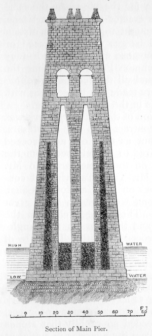
The basin at Corpach formed the southernmost point of the
intended canal. It is situated at the head of Loch Eil, amidst
some of the grandest scenery of the Highlands. Across the Loch
is the little town of Fort William, one of the forts established at
the end of the seventeenth century to keep the wild Highlanders in
subjection. Above it rise hills over hills, of all forms and
sizes, and of all hues, from grass-green below to heather-brown and
purple above, capped with heights of weather-beaten grey; while
towering over all stands the rugged mass of Ben Nevis a mountain
almost unsurpassed for picturesque grandeur. Along the western
foot of the range, which extends for some six or eight miles, lies a
long extent of brown bog, on the verge of which, by the river Lochy,
stand the ruins of Inverlochy Castle.
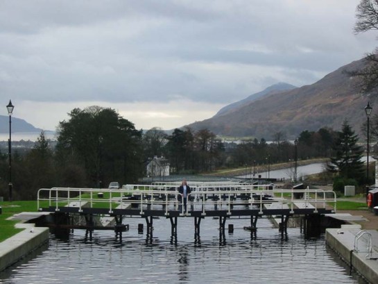
The works at Corpach involved great labour, and extended over
a long series of years. The difference between the level of
Loch Ell and Loch Lochy is ninety feet, while the distance between
them was less than eight miles. It was therefore necessary to
climb up the side of the hill by a flight of eight gigantic locks,
clustered together, and which Telford named Neptune's Staircase.
The ground passed over was in some places very difficult, requiring
large masses of embankment, the slips of which in the course of the
work frequently occasioned serious embarrassment. The basin on
Loch Ell, on the other hand, was constructed amidst rock, and
considerable difficulty was experienced in getting in the necessary
cofferdam for the construction of the opening into the sea-lock, the
entrance-sill of which was laid upon the rock itself, so that there
was a depth of 21 feet of water upon it at high water of neap tides.
Neptune's Staircase on the Caledonian Canal at
Banavie, near Fort William.
Eight locks ascend 64 feet (19.5 metres).
Picture Wikipedia.
At the same time that the works at Corpach were begun, the
dock or basin at the north-eastern extremity of the canal, situated
at Clachnaharry, on the shore of Loch Beauly, was also laid out, and
the excavations and embankments were carried on with considerable
activity. This dock was constructed about 967 yards long, and
upwards of 162 yards in breadth, giving an area of about 32
acres,—forming, in fact, a harbour for the vessels using the canal.
The dimensions of the artificial waterway were of unusual size, as
the intention was to adapt it throughout for the passage of a 32-gun
frigate of that day, fully equipped and laden with stores. The
canal, as originally resolved upon, was designed to be 110 feet wide
at the surface, and 50 feet at the bottom, with a depth in the
middle of 20 feet; though these dimensions were somewhat modified in
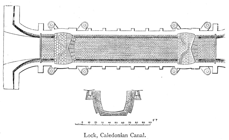
the execution of the work. The locks were of corresponding
large dimensions, each being from 170 to 180 feet long, 40 broad,
and 20 deep.
The Clachnaharry swing bridge looking towards the
final stretch of the Caledonian Canal -
the sea lock and Beauly Firth. Picture
Wikimedia Commons.
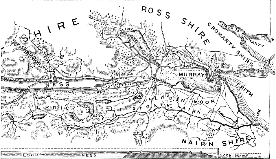
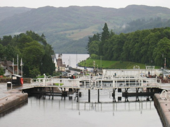
Between these two extremities of the canal—Corpach on the
south-west and Clachnaharry on the north-east—extends the chain of
fresh-water lochs: Loch Lochy on the south; next Loch Oich; then
Loch Ness; and lastly, furthest north, the small Loch of Dochfour.
The whole length of the navigation is 60 miles 40 chains, of which
the navigable lochs constitute about 40 miles, leaving only about 20
miles of canal to be constructed, but of unusually large dimensions
and through a very difficult country.
|
|
The summit loch of the whole is Loch Oich, the surface of
which is exactly a hundred feet above high water-mark, both at
Inverness and Fort William; and to this sheet of water the
navigation climbs up by a series of locks from both the eastern and
western seas. The whole number of these is twenty-eight: the
entrance-lock at Clachnaharry, constructed on piles, at the end of
huge embankments, forced out into deep water, at Loch Beauly;
another at the entrance to the capacious artificial harbour above
mentioned, at Muirtown; four connected locks at the southern end of
this basin; a regulating lock a little to the north of Loch Dochfour;
five contiguous locks at Fort Augustus, at the south end of Loch
Ness; another, called the Kytra Lock, about midway between Fort
Augustus and Loch Oich; a regulating lock at the north-east end of
Loch Oich; two contiguous locks between Lochs Oich and Lochy; a
regulating lock at the southwest end of Loch Lochy; next, the grand
series of locks, eight in number, called "Neptune's Staircase," at
Bannavie, within a mile and a quarter of the sea; two locks,
descending to Corpach basin; and lastly, the great entrance or
sea-lock at Corpach.
The Caledonian Canal at Fort Augustus. Picture
Wikimedia Commons.
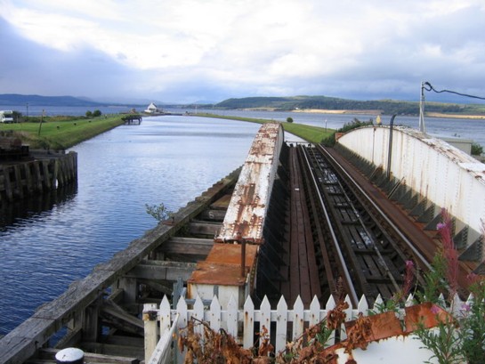
The northern entrance-lock from the sea at Loch Beauly is at
Clachnaharry, near Inverness. The works here were not
accomplished without much difficulty as well as labour, partly from
the very gradual declivity of the shore, and partly from the
necessity of placing the sea-lock on absolute mud, which afforded no
foundation other than what was created by compression and
pile-driving. The mud was forced down by throwing upon it an
immense load of earth and stones, which was left during twelve
months to settle; after which a shaft was sunk to a solid
foundation, and the masonry of the sea-lock was then founded and
built therein.

In the 'Sixteenth Report of the Commissioners of the
Caledonian Canal,' the following reference is made to this important
work, which was finished in 1812: "The depth of the mud on which it
may be said to be artificially seated is not less than 60 feet; so
that it cannot be deemed superfluous, at the end of seven years, to
state that no subsidence is discoverable; and we presume that the
entire lock, as well as every part of it, may now be deemed as
immovable, and as little liable to destruction, as any other large
mass of masonry. This was the most remarkable work performed
under the immediate care of Mr. Matthew Davidson, our superintendent
at Clachnaharry, from 1804 till the time of his decease. He
was a man perfectly qualified for the employment by inflexible
integrity, unwearied industry, and zeal to a degree of anxiety, in
all the operations committed to his care." [p.291]
As may naturally be supposed, the execution of these great
works involved vast labour and anxiety. They were designed
with much skill, and executed with equal ability. There were
lock-gates to be constructed, principally of cast iron, sheathed
with pine planking. Eight public road bridges crossed the line
of the canal, which were made of cast iron, and swung horizontally.
There were many mountain streams, swollen to torrents in winter,
crossing under the canal, for which abundant water-way had to be
provided, involving the construction of numerous culverts, tunnels,
and under-bridges of large dimensions. There were also
powerful sluices to let off the excess of water sent down from the
adjacent mountains into the canal during winter. Three of
these, of great size, high above the river Lochy, are constructed at
a point where the canal is cut through the solid rock; and the sight
of the mass of waters rushing down into the valley beneath, gives an
impression of power which, once seen, is never forgotten.
These great works were only brought to a completion after the
labours of many years, during which the difficulties encountered in
their construction had swelled the cost of the canal far beyond the
original estimate. The rapid advances which had taken place in
the interval in the prices of labour and materials also tended
greatly to increase the expenses, and, after all, the canal, when
completed and opened, was comparatively little used. This was
doubtless owing, in a great measure, to the rapid changes which
occurred in the system of navigation shortly after the projection of
the undertaking. For these Telford was not responsible.
He was called upon to make the canal, and he did so in the best
manner. Engineers are not required to speculate as to the
commercial value of the works they are required to construct; and
there were circumstances connected with the scheme of the Caledonian
Canal which removed it from the category of mere commercial
adventures. It was a Government project, and it proved a
failure as a paying concern. Hence it formed a prominent topic
for discussion in the journals of the day; but the attacks made upon
the Government because of their expenditure on the hapless
undertaking were perhaps more felt by Telford, who was its engineer,
than by all the ministers of state conjoined.
"The unfortunate issue of this great work," writes the
present engineer of the canal, to whom we are indebted for many of
the preceding facts, "was a grievous disappointment to Mr. Telford,
and was in fact the one great bitter in his otherwise unalloyed cup
of happiness and prosperity. The undertaking was maligned by
thousands who knew nothing of its character. It became 'a dog
with a bad name,' and all the proverbial consequences followed.
The most absurd errors and misconceptions were propagated respecting
it from year to year, and it was impossible during Telford's
lifetime to stem the torrent of popular prejudice and objurgation.
It must, however, be admitted, after a long experience, that Telford
was greatly over-sanguine in his expectations as to the national
uses of the canal, and he was doomed to suffer acutely in his
personal feelings, little though he may have been personally to
blame, the consequences of what in this commercial country is
regarded as so much worse than a crime, namely, a financial
mistake." [p.293]
Mr. Telford's great sensitiveness made him feel the ill
success of this enterprise far more than most other men would have
done. He was accustomed to throw himself into the projects on
which he was employed with an enthusiasm almost poetic. He
regarded them not merely as so much engineering, but as works which
were to be instrumental in opening up the communications of the
country and extending its civilisation. Viewed in this light,
his canals, roads, bridges, and harbours were unquestionably of
great national importance, though their commercial results might not
in all cases justify the estimates of their projectors. To
refer to like instances—no one can doubt the immense value and
public uses of Mr. Rennie's Waterloo Bridge or Mr. Robert
Stephenson's Britannia and Victoria Bridges, though every one knows
that, commercially, they have been failures. But it is
probable that neither of these eminent engineers gave himself
anything like the anxious concern that Telford did about the
financial issue of his undertaking. Were railway engineers to
fret and vex themselves about the commercial value of the schemes in
which they have been engaged, there are few of them but would be so
haunted by the ghosts of wrecked speculations that they could
scarcely lay their heads upon their pillows for a single night in
peace.
While the Caledonian Canal was in progress, Mr. Telford was
occupied in various works of a similar kind in England and Scotland,
and also upon one in Sweden. In 1804, while on one of his
journeys to the north, he was requested by the Earl of Eglinton and
others to examine a project for making a canal from Glasgow to
Saltcoats and Ardrossan, on the north-western coast of the county of
Ayr, passing near the important manufacturing town of Paisley.
A new survey of the line was made, and the works were carried on
during several successive years until a very fine capacious canal
was completed, on the same level, as far as Paisley and Johnstown.
But the funds of the company falling short, the works were stopped,
and the canal was carried no further. Besides, the measures
adopted by the Clyde Trustees to deepen the bed of that river and
enable ships of large burden to pass up as high as Glasgow, had
proved so successful that the ultimate extension of the canal to
Ardrossan was no longer deemed necessary, and the prosecution of the
work was accordingly abandoned. But as Mr. Telford has
observed, no person suspected, when the canal was laid out in 1805,
"that steamboats would not only monopolise the trade of the Clyde,
but penetrate into every creek where there is water to float them,
in the British Isles and the continent of Europe, and be seen in
every quarter of the world."
Another of the navigations on which Mr. Telford was long
employed was that of the river Weaver in Cheshire. It was only
twenty-four miles in extent, but of considerable importance to the
country through which it passed, accommodating the
salt-manufacturing districts, of which the towns of Nantwich,
Northwich, and Frodsham are the centres. The channel of the
river was extremely crooked and much obstructed by shoals, when
Telford took the navigation in hand in the year 1807, and a number
of essential improvements were made in it, by means of new locks,
weirs, and side cuts, which had the effect of greatly improving the
communications of these important districts.
In the following year we find our engineer consulted, at the
instance of the King of Sweden, on the best mode of constructing the
Gotha Canal, between Lake Wenern and the Baltic, to complete the
communication with the North Sea. In 1808, at the invitation
of Count Platen, Mr. Telford visited Sweden and made a careful
survey of the district. The service occupied him and his
assistants two months, after which he prepared and sent in a series
of detailed plans and sections, together with an elaborate report on
the subject. His plans having been adopted, he again visited
Sweden in 1810, to inspect the excavations which had already been
begun, when he supplied the drawings for the locks and bridges.
With the sanction of the British Government, he at the same time
furnished the Swedish contractors with patterns of the most improved
tools used in canal making, and took with him a number of
experienced lock-makers and navvies for the purpose of instructing
the native workmen.
The construction of the Gotha Canal was an undertaking of
great magnitude and difficulty, similar in many respects to the
Caledonian Canal, though much more extensive. The length of
artificial canal was 55 miles, and of the whole navigation,
including the lakes, 120 miles. The locks are 120 feet long
and 24 feet broad; the width of the canal at bottom being 42 feet,
and the depth of water 10 feet. The results, so far as the
engineer was concerned, were much more satisfactory than in the case
of the Caledonian Canal. While in the one case he had much
obloquy to suffer for the services he had given, in the other he was
honoured and feted as a public benefactor, the King conferring upon
him the Swedish order of knighthood, and presenting him with his
portrait set in diamonds.
|
One of the cruise ships that now ply the Gotha Canal [p.296].
Photo courtesy Wendy Austin.
|
Among the various canals throughout England which Mr. Telford
was employed to construct or improve, down to the commencement of
the railway era, were the Gloucester and Berkeley Canal, in 1818; [p.297-1]
the Grand Trunk Canal, in 1822; [p.297-2]
the Harecastle Tunnel, which he constructed anew, in 1824-7; the
Birmingham Canal, in 1824; [p.297-3]
and the Macclesfield, and Birmingham and Liverpool Junction Canals,
in 1825. The Gloucester and Berkeley Canal Company had been
unable to finish their works, begun some thirty years before; but
with the assistance of a loan of £160,000 from the Exchequer Bill
Loan Commissioners, they were enabled to proceed with the completion
of their undertaking. A capacious canal was cut from Gloucester to
Sharpness Point, about sixteen miles down the Severn, which had the
effect of greatly improving the convenience of the port of
Gloucester; and by means of this navigation, ships of large burden
can now avoid the circuitous and difficult passage of the higher
part of the river, very much to the advantage of the trade of the
place. |

The start of the Birmingham Canal at Gas Street Basin, central Birmingham.
Picture Wikipedia.
|
The formation of a new tunnel through Harecastle Hill, for
the better accommodation of the boats passing along the Grand Trunk
Canal, was a formidable work. The original tunnel, it will be
remembered, [p.298] was laid out
by Brindley, about fifty years before, and occupied eleven years in
construction. But the engineering appliances of those early
days were very limited; the pumping powers of the steam-engine had
not been fairly developed, and workmen were as yet only
half-educated in the expert use of tools. The tunnel, no
doubt, answered the purpose for which it was originally intended,
but it was very soon found too limited for the traffic passing along
the navigation. It was little larger than a sewer, and
admitted the passage of only one narrow boat, seven feet wide, at a
time, involving very heavy labour on the part of the men who worked
it through. This was performed by what was called legging.
The Leggers lay upon the deck of the vessel, or upon a board
slightly projecting from either side of it, and, by thrusting their
feet against the slimy roof or sides of the tunnel—walking
horizontally as it were—they contrived to push it through. But
it was no better than horse-work; and after "legging" Harecastle
Tunnel, which is more than a mile and a half long, the men were
usually completely exhausted, and as wet from perspiration as if
they had been dragged through the canal itself. The process
occupied about two hours, and by the time the passage of the tunnel
was made, there was usually a collection of boats at the other end
waiting their turn to pass. Thus much contention and confusion
took place amongst the boatmen—a very rough class of labourers—and
many furious battles were fought by the claimants for the first turn
"through." Regulations were found of no avail to settle these
disputes, still less to accommodate the large traffic which
continued to keep flowing along the line of the Grand Trunk, and
steadily increased with the advancing trade and manufactures of the
country. Loud complaints were made by the public, but they
were disregarded for many years; and it was not until the
proprietors were threatened with rival canals and railroads that
they determined on—what they could no longer avoid if they desired
to retain the carrying trade of the district—the enlargement of the
Harecastle Tunnel.
Mr. Telford was requested to advise the Company what course
was most proper to be adopted in the matter, and after examining the
place, he recommended that an entirely new tunnel should be
constructed, nearly parallel with the old one, but of much larger
dimensions. The work was begun in 1824, and completed in 1827,
in less than three years. There were at that time throughout
the country plenty of skilled labourers and contractors, many of
them trained by their experience upon Telford's own works, whereas
Brindley had in a great measure to make his workmen out of the
rawest material. Telford also had the advantage of greatly
improved machinery and an abundant supply of money—the Grand Trunk
Canal Company having become prosperous and rich, paying large
dividends. It is therefore meet, while eulogising the despatch
with which he was enabled to carry out the work, to point out that
the much greater period occupied in the earlier undertaking is not
to be set down to the disparagement of Brindley, who had
difficulties to encounter which the later engineer knew nothing of.
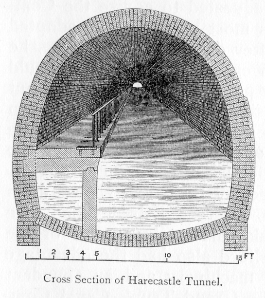
The length of the new tunnel is 2,926 yards; it is 16 feet
high and 14 feet broad, 4 feet 9 inches of the breadth being
occupied by the towing-path—for "legging" was now dispensed with,
and horses hauled along the boats instead of their being thrust
through by men. The tunnel is in so perfectly straight a line
that its whole length can be seen through at one view; and though it
was constructed by means of fifteen different pitshafts sunk to the
same line along the length of the tunnel, the workmanship is so
perfect that the joinings of the various lengths of brickwork are
scarcely discernible. The convenience afforded by the new
tunnel was very great, and Telford mentions that, on surveying it in
1829, he asked a boatman coming out of it how he liked it? "I
only wish," he replied, "that it reached all the way to Manchester!"
At the time that Mr. Telford was engaged upon the tunnel at
Harecastle, he was employed to improve and widen the Birmingham
Canal, another of Brindley's works. Though the accommodation
provided by it had been sufficient for the traffic when originally
constructed, the expansion of the trade of Birmingham and the
neighbourhood, accelerated by the formation of the canal itself, had
been such as completely to outgrow its limited convenience and
capacity, and it's enlargement and improvement now became absolutely
necessary. Brindley's Canal, for the sake of cheapness of
construction—money being much scarcer and more difficult to be
raised in the early days of canals—was also winding and crooked; and
it was considered desirable to shorten and straighten it by cutting
off the bends at different places. At the point at which the
canal entered Birmingham, it had become "little better than a
crooked ditch, with scarcely the appearance of a towing-path, the
horses frequently sliding and staggering in the water, the
hauling-lines sweeping the gravel into the canal, and the
entanglement at the meeting of boats being incessant; whilst at the
locks at each end of the short summit at Smethwick crowds of boatmen
were always quarrelling, or offering premiums for a preference of
passage; and the mine-owners, injured by the delay, were loud in
their just complaints." [p.301]
Mr. Telford proposed an effective measure of improvement,
which was taken in hand without loss of time, and carried out,
greatly to the advantage of the trade of the district. The
numerous bends in the canal were cut off, the water-way was greatly
widened, the summit at Smethwick was cut down to the level on either
side, and a straight canal, forty feet wide, without a lock, was
thus formed as far as Bilston and Wolverhampton; while the length of
the main line between Birmingham and Autherley, along the whole
extent of the "Black country," was reduced from twenty-two to
fourteen miles. At the same time the obsolete curvatures in
Brindley's old canal were converted into separate branches or
basins, for the accommodation of the numerous mines and
manufactories on either side of the main line. In consequence
of the alterations which had been made in the canal, it was found
necessary to construct numerous large bridges. One of these—a
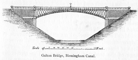
cast iron bridge, at Galton, of 150 feet span—has been much admired
for its elegance, lightness, and economy of material. Several
others of cast iron were constructed at different points, and at one
place the canal itself is carried along on an aqueduct of the same
material as at Pont-Cysylltau. The whole of these extensive
improvements were carried out in the short space of two years'; and
the result was highly satisfactory, "proving," as Mr. Telford
himself observes, "that where business is extensive, liberal
expenditure of this kind is true economy."
 |
Telford's Galton Bridge (1829), Smethwick, West Midlands. Picture
Wikipedia.
|
In 1825 Mr. Telford was called upon to lay out a canal to
connect the Grand Trunk, at the north end of Harecastle Tunnel, with
the rapidly improving towns of Congleton and Macclesfield. The
line was twenty-nine miles in length, ten miles on one level from
Harecastle to beyond Congleton; then, ascending 114 feet by eleven
locks, it proceeded for five miles on a level past Macclesfield, and
onward to join the Peak Forest Canal at Marple. The navigation
was thus conducted upon two levels, each of considerable length; and
it so happened that the trade of each was in a measure distinct, and
required separate accommodation. The traffic of the whole of
the Congleton district had ready access to the Grand Trunk system,
without the labour, expense, and delay involved by passing the boats
through locks; while the coals brought to Macclesfield to supply the
mills there were carried throughout upon the upper level, also
without lockage. The engineer's arrangement proved highly
judicious, and furnishes an illustration of the tact and judgment
which he usually displayed in laying out his works for practical
uses. Mr. Telford largely employed cast iron in the
construction of this canal, using it in the locks and gates, as well
as in an extensive aqueduct which it was necessary to construct over
a deep ravine, after the plan pursued by him at Pont-Cysylltau and
other places.
The last canal constructed by Mr. Telford was the Birmingham
and Liverpool Junction, extending from the Birmingham Canal, near
Wolverhampton, in nearly a direct line, by Market Drayton, Nantwich,
and through the city of Chester, by the Ellesmere Canal, to
Ellesmere Port on the Mersey. The proprietors of canals were
becoming alarmed at the numerous railways projected through the
districts heretofore served by their water-ways; and among other
projects one was set on foot, as early as 1825, for constructing a
line of railway from London to Liverpool. Mr. Telford was
consulted as to the best means of protecting existing investments,
and his advice was to render the canal system as complete as it
could be made; for he entertained the conviction, which has been
justified by experience, that such navigations possessed peculiar
advantages for the conveyance of heavy goods, and that, if the
interruptions presented by locks could be done away with, or
materially reduced, a large portion of the trade of the country must
continue to be carried by the water roads. The new line
recommended by him was approved and adopted, and the works commenced
in 1826. A second complete route was thus opened up between
Birmingham and Liverpool, and Manchester, by which the distance was
shortened twelve miles, and the delay occasioned by 320 feet of
upward and downward lockage was done away with.
Telford was justly proud of his canals, which were the finest
works of their kind that had yet been executed in England.
Capacious, convenient, and substantial, they embodied his most
ingenious contrivances, and his highest engineering skill.
Hence we find him writing to a friend at Langholm, that, so soon as
he could find "sufficient leisure from his various avocations in his
own unrivalled and beloved island," it was his intention to visit
France and Italy, for the purpose of ascertaining what foreigners
had been able to accomplish, compared with ourselves, in the
construction of canals, bridges, and harbours. "I have no
doubt," said he, "as to their inferiority. During the war just
brought to a close, England has not only been able to guard her own
head and to carry on a gigantic struggle, but at the same time to
construct canals, roads, harbours, bridges—magnificent works of
peace—the like of which are probably not to be found in the world.
Are not these things worthy of a nation's pride?"
――――♦――――
CHAPTER XI.
TELFORD AS A ROAD-MAKER.
MR.
TELFORD'S
extensive practice as a bridge-builder led his friend Southey to
designate him "Pontifex Maximus." Besides the numerous bridges
erected by him in the West of England, we have found him furnishing
designs for about twelve hundred in the Highlands, of various
dimensions, some of stone and others of iron. His practice in
bridge-building had, therefore, been of an unusually extensive
character, and Southey's sobriquet was not ill applied. But
besides being a great bridge-builder, Telford was also a great
road-maker. With the progress of industry and trade, the easy
and rapid transit of persons and goods had come to be regarded as an
increasing object of public interest. Fast coaches now ran
regularly between all the principal towns of England; every effort
being made, by straightening and shortening the roads, cutting down
hills, and carrying embankments across valleys and viaducts over
rivers, to render travelling by the main routes as easy and
expeditious as possible.
Attention was especially turned to the improvement of the
longer routes, and to perfecting the connection of London with the
chief towns of Scotland and Ireland. Telford was early called
upon to advise as to the repairs of the road between Carlisle and
Glasgow, which had been allowed to fall into a wretched state; as
well as the formation of a new line from Carlisle, across the
counties of Dumfries, Kirkcudbright, and Wigton, to Port Patrick,
for the purpose of ensuring a more rapid communication with Belfast
and the northern parts of Ireland. Although Glasgow had become
a place of considerable wealth and importance, the roads to it,
north of Carlisle, continued in a very unsatisfactory state.
It was only in July, 1788, that the first mail-coach from London had
driven into Glasgow by that route, when it was welcomed by a
procession of the citizens on horseback, who went out several miles
to meet it. But the road had been shockingly made, and before
long had become almost impassable. Robert Owen states that, in
1795, it took him two days and three nights' incessant travelling to
get from Manchester to Glasgow, and he mentions that the coach had
to cross a well-known dangerous mountain at midnight, called
Erickstane Brae, which was then always passed with fear and
trembling. [p.306-1]
As late as the year 1814 we find a Parliamentary Committee
declaring the road between Carlisle and Glasgow to be in so ruinous
a state as often seriously to delay the mail and endanger the lives
of travellers. The bridge over Evan Water was so much decayed,
that one day the coach and horses fell through it into the river,
when "one passenger was killed, the coachman survived only a few
days, and several other persons were dreadfully maimed; two of the
horses being also killed." [p.306-2]
The remaining part of the bridge continued for some time unrepaired,
just space enough being left for a single carriage to pass.
The road trustees seemed to be helpless, and did nothing; a local
subscription was tried and failed, the district passed through being
very poor; but as the road was absolutely required for more than
merely local purposes, it was eventually determined to undertake its
reconstruction as a work of national importance, and £50,000 was
granted by Parliament with this object, under the provisions of the
Act passed in 1816. The works were placed under Mr. Telford's
charge; and an admirable road was very shortly under construction
between Carlisle and Glasgow. That part of it between Hamilton
and Glasgow, eleven miles in length, was however left in the hands
of local trustees, as was the diversion of thirteen miles at the
boundary of the counties of Lanark and Dumfries, for which a
previous Act had been obtained. The length of new line
constructed by Mr. Telford was sixty-nine miles, and it was probably
the finest piece of road which up to that time had been made.
His ordinary method of road-making in the Highlands was,
first to level and drain; then, like the Romans, to lay a solid
pavement of large stones, the round or broad end downwards, as close
as they could be set. The points of the latter were then
broken off, and a layer of stones broken to about the size of
walnuts, were laid upon them, and over all a little gravel if at
hand. A road thus formed soon became bound together, and for
ordinary purposes was very durable.
But where the traffic, as in the case of the Carlisle and
Glasgow road, was expected to be very heavy, Telford took much
greater pains. Here he paid special attention to two points:
first, to lay it out as nearly as possible upon a level, so as to
reduce the draught to horses dragging heavy vehicles,—one in thirty
being about the severest gradient at any part of the road. The
next point was to make the working, or middle portion of the road,
as firm and substantial as possible, so as to bear, without
shrinking, the heaviest weight likely to be brought over it.
With this object he specified that the metal bed was to be formed in
two layers, rising about four inches towards the centre --the bottom
course being of stones (whinstone, limestone, or hard freestone),
seven inches in depth. These were to be carefully set by hand,
with the broadest ends downwards, all cross-bonded or jointed, no
stone being more than three inches wide on the top. The spaces
between them were then to be filled up with smaller stones, packed
by hand, so as to bring the whole to an even and firm surface.
Over this a top course was to be laid, seven inches in depth,
consisting of properly broken hard whinstones, none exceeding six
ounces in weight, and each to be able to pass through a circular
ring, two inches and a half in diameter; a binding of gravel, about
an inch in thickness, being placed over all. A drain crossed
under the bed of the bottom layer to the outside ditch in every
hundred yards. The result was an admirably easy, firm, and dry
road, capable of being travelled upon in all weathers, and standing
in comparatively small need of repairs.

A similar practice was introduced in England about the same
time by Mr. Macadam; and, though his method was not so thorough as
that of Telford, it was usefully employed on most of the high roads
throughout the kingdom. Mr. Macadam's notice was first called
to the subject while acting as one of the trustees of a road in
Ayrshire. Afterwards, while employed as Government agent for
victualling the navy in the western parts of England, he continued
the study of road-making, keeping in view the essential conditions
of a compact and durable substance and a smooth surface. At
that time the attention of the Legislature was not so much directed
to the proper making and mending of the roads, as to suiting the
vehicles to them such as they were; and they legislated backwards
and forwards for nearly half a century as to the breadth of wheels.
Macdam was, on the other hand, of opinion that the main point was to
attend to the nature of the roads on which the vehicles were to
travel. Most roads were then made with gravel, or flints
tumbled upon them in their natural state, and so rounded that they
had no points of contact, and rarely became consolidated. When
a heavy vehicle of any sort passed over them, their loose structure
presented no resistance; the material was thus completely disturbed,
and they often became almost impassable. Macadam's practice
was this: to break the stones into angular fragments, so that a bed
several inches in depth should be formed, the material best adapted
for the purpose being fragments of granite, greenstone, or basalt;
to watch the repairs of the road carefully during the process of
consolidation, filling up the inequalities caused by the traffic
passing over it, until a hard and level surface had been obtained.
Thus made, the road would last for years without further attention.
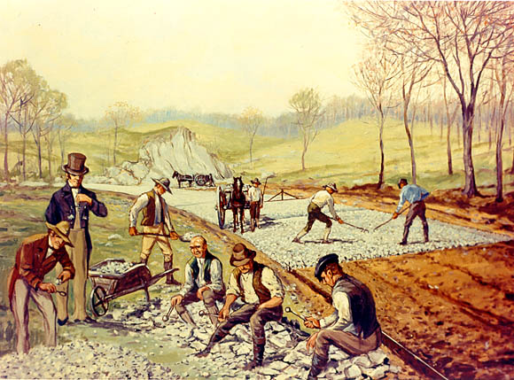
In 1815 Mr. Macadam devoted himself with great enthusiasm to
road-making as a profession, and being appointed surveyor-general of
the Bristol roads, he had full opportunities of exemplifying his
system. It proved so successful that the example set by him
was quickly followed over the entire kingdom. Even the streets
of many large towns were Macadamised. In carrying out
his improvements, however, Mr. Macadam spent several thousand pounds
of his own money, and in 1825, having proved this expenditure before
a Committee of the House of Commons, the amount was reimbursed to
him, together with an honorary tribute of two thousand pounds.
Mr. Macadam died poor, but, as he himself said, "at least an honest
man." By his indefatigable exertions and his success as a
road-maker, by greatly saving animal labour, facilitating commercial
intercourse, and rendering travelling easy and expeditious, he
entitled himself to the reputation of a public benefactor.
|
Construction of the first road in the United States (1823) on the principles of
John Loudon McAdam (1756-1836). [p.311]
Picture Wikipedia.
|
Owing to the mountainous nature of the country through which
Telford's Carlisle and Glasgow road passes, the bridges are
unusually numerous and of large dimensions. Thus, the
Fiddler's Burn Bridge is of three arches, one of 150 and two of 105
feet span each. There are fourteen other bridges, presenting
from one to three arches, of from 20 to go feet span. But the
most picturesque and remarkable bridge constructed by Telford in
that district was upon another line of road subsequently carried out
by him, in the upper part of the county of Lanark, and crossing the
main line of the Carlisle and Glasgow road almost at right angles.
Its northern and eastern part formed a direct line of communication
between the great cattle markets of Falkirk, Grief, and Doune, and
Carlisle and the West of England. It was carried over deep
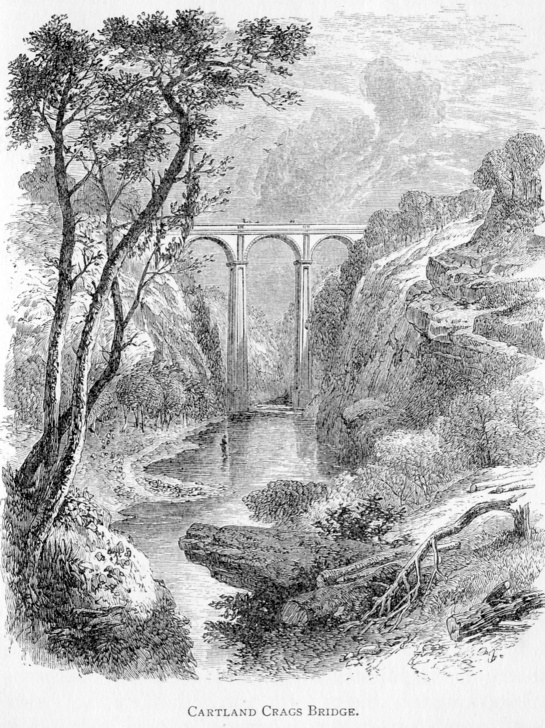
ravines by several lofty bridges, the most formidable of which was
that across the Mouse Water at Cartland Crags, about a mile to the
west of Lanark. The stream here flows through a deep rocky
chasm, the sides of which are in some places about four hundred feet
high. At a point where the height of the rocks is considerably
less, but still most formidable, Telford spanned the ravine with the
beautiful bridge represented in the engraving on page 311, its
parapet being 129 feet above the surface of the water beneath.
The reconstruction of the western road from Carlisle to
Glasgow, which Telford had thus satisfactorily carried out, shortly
led to similar demands from the population on the eastern side of
the kingdom. The spirit of road reform was now fairly on foot.
Fast coaches and wheel-carriages of all kinds had become greatly
improved, so that the usual rate of travelling had advanced from
five or six to nine or ten miles an hour. The desire for the
rapid communication of political and commercial intelligence was
found to increase with the facilities for supplying it; and, urged
by the public wants, the Post-Office authorities were stimulated to
unusual efforts in this direction. Numerous surveys were made
and roads laid out, so as to improve the main line of communication
between London and Edinburgh and the intermediate towns. The
first part of this road taken in hand was the worst—that lying to
the north of Catterick Bridge, in Yorkshire. A new line was
surveyed by West Auckland to Hexham, passing over Carter Fell to
Jedburgh, and thence to Edinburgh; but was rejected as too crooked
and uneven. Another was tried by Aldstone Moor and Bewcastle,
and rejected for the same reason. The third line proposed was
eventually adopted as the best, passing from Morpeth, by Wooler and
Coldstream, to Edinburgh; saving rather more than fourteen miles
between the two points, and securing a line of road of much more
favourable gradients.
Cartland Crags Bridge: picture from
"Scotland Illustrated" by William Beattie, 1838.
The principal bridge on this new highway was at Pathhead,
over the Tyne, about eleven miles south of Edinburgh. To
maintain the level, so as to avoid the winding of the road down a
steep descent on one side of the valley and up an equally steep
ascent on the other, Telford ran out a lofty embankment from both
sides, connecting their ends by means of a spacious bridge.
The structure at Pathhead is of five arches, each 50 feet span, with
25 feet rise from their springing, 49 feet above the bed of the
river. Bridges of a similar character were also thrown over
the deep ravines of Cranston Dean and Cotty Burn, in the same
neighbourhood. At the same time a useful bridge was built on
the same line of road at Morpeth, in Northumberland, over the river
Wansbeck. It consisted of three arches, of which the centre
one was 50 feet span, and two side-arches 40 feet each; the breadth
between the parapets being 30 feet.
The advantages derived from the construction of these new
roads were found to be so great, that it was proposed to do the like
for the remainder of the line between London and Edinburgh; and at
the instance of the Post-Office authorities, with the sanction of
the Treasury, Mr. Telford proceeded to make detailed surveys of an
entire new post-road between London and Morpeth. In laying it
out, the main points which he endeavoured to secure were directness
and flatness; and 100 miles of the proposed new Great North Road,
south of York, were laid out in a perfectly straight line.
This survey, which was begun in 1824, extended over several years;
and all the requisite arrangements had been made for beginning the
works, when the result of the locomotive competition at Rainhill, in
1829, had the effect of directing attention to that new method of
travelling, fortunately in time to prevent what would have proved,
for the most part, an unnecessary expenditure, on works soon to be
superseded by a totally different order of things.
The most important road-improvements actually carried out
under Mr. Telford's immediate superintendence were those on the
western side of the island, with the object of shortening the
distance and facilitating the communication between London and
Dublin by way of Holyhead, as well as between London and Liverpool.
At the time of the Union, the mode of transit between the capital of
Ireland and the metropolis of the United Kingdom was tedious,
difficult, and full of peril. In crossing the Irish Sea to
Liverpool, the packets were frequently tossed about for days
together. On the Irish side, there was scarcely the pretence
of a port, the landing-place being within the bar of the river
Liffey, inconvenient at all times, and in rough weather extremely
dangerous. To avoid the long voyage to Liverpool, the passage
began to be made from Dublin to Holyhead, the nearest point of the
Welsh coast. Arrived there, the passengers were landed upon
rugged, unprotected rocks, without a pier or landing convenience of
any kind. [p.316] But the
traveller's perils were not at an end, comparatively speaking they
had only begun. From Holyhead, across the island of Anglesea,
there was no made road, but only a miserable track, circuitous and
craggy, full of terrible jolts, round bogs and over rocks, for a
distance of twenty-four miles. Having reached the Menai
Strait, the passengers had again to take to an open ferry-boat
before they could gain the main land. The tide ran with great
rapidity through the Strait, and, when the wind blew strong, the
boat was liable to be driven far up or down the channel, and was
sometimes swamped altogether. The perils of the Welsh roads
had next to be encountered, and these were in as bad a condition at
the beginning of the present century as those of the Highlands above
described. Through North Wales they were rough, narrow, steep,
and unprotected, mostly unfenced, and in winter almost impassable.
The whole traffic on the road between Shrewsbury and Bangor was
conveyed by a small cart, which passed between the two places once a
week in summer. As an illustration of the state of the roads
in South Wales, which were quite as bad as those in the North, we
may state that, in 1803, when the late Lord Sudeley took home his
bride from the neighbourhood of Welshpool to his residence only
thirteen miles distant, the carriage in which the newly married pair
rode stuck in a quagmire, and the occupants, having extricated
themselves from their perilous situation, performed the rest of
their journey on foot.
The first step taken was to improve the landing-places on
both the Irish and Welsh sides of St. George's Channel, and for this
purpose Mr. Rennie was employed in 1801. The result was, that
Howth on the one coast, and Holyhead on the other, were fixed upon
as the most eligible sites for packet stations. Improvements,
however, proceeded slowly, and it was not until 1810 that a sum of
£10,000 was granted by Parliament to enable the necessary works to
be begun. Attention was then turned to the state of the roads,
and here Mr. Telford's services were called into requisition.
As early as 1808 it had been determined by the Post-Office
authorities to put on a mail-coach between Shrewsbury and Holyhead;
but it was pointed out that the roads in North Wales were so rough
and dangerous that it was doubtful whether the service could be
conducted with safety. Attempts were made to enforce the law
with reference to their repair, and no less than twenty-one
townships were indicted by the Postmaster-General. The route
was found too perilous even for a riding post, the legs of three
horses having been broken in one week. [p.318]
The road across Anglesea was quite as bad. Sir Henry Parnell
mentioned, in 1819, that the coach had been overturned beyond
Gwynder, going down one of the hills, when a friend of his was
thrown a considerable distance from the roof into a pool of water.
Near the post-office of Gwynder, the coachman had been thrown from
his seat by a violent jolt, and broken his leg. The
post-coach, and also the mail, had been overturned at the bottom of
Penmyndd Hill; and the route was so dangerous that the London
coachmen, who had been brought down to "work" the country, refused
to continue the duty because of its excessive dangers. Of
course, anything like a regular mail-service through such a district
was altogether impracticable.
The indictments of the townships proved of no use; the
localities were too poor to provide the means required to construct
a line of road sufficient for the conveyance of mails and passengers
between England and Ireland. The work was really a national
one, to be carried out at the national cost. How was this best
to be done? Telford recommended that the old road between
Shrewsbury and Holyhead (109 miles long) should be shortened by
about four miles, and made as nearly as possible on a level; the new
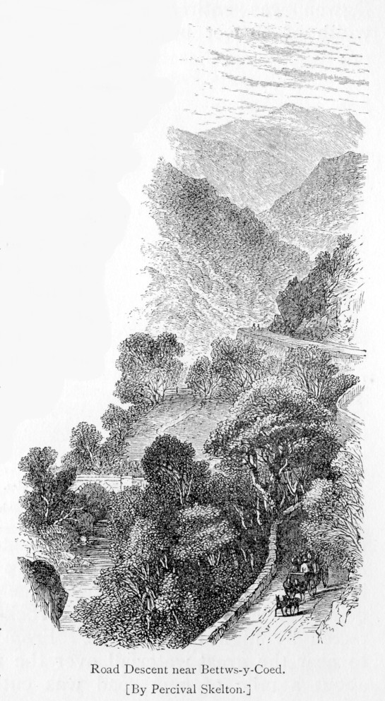
line proceeding from Shrewsbury by Llangollen, Corwen, Bettws-y-Coed,
Capel-Curig, and Bangor, to Holyhead. Mr. Telford also
proposed to cross the Menai Strait by means of a cast iron bridge,
hereafter to be described.
Although a complete survey was made in 1811, nothing was done
for several years. The mail-coaches continued to be
overturned, and stagecoaches, in the tourist season, to break down
as before. [p.319] The
Irish mail-coach took forty-one hours to reach Holyhead from the
time of its setting out from St. Martin's-le-Grand; the journey was
performed at the rate of only 6¾ miles an hour, the Mail arriving in
Dublin on the third day. The Irish members made many
complaints of the delay and dangers to which they were exposed in
travelling up to town. But, although there was much
discussion, no money was voted until the year 1815, when Sir Henry
Parnell vigorously took the question in hand and successfully
carried it through. A Board of Parliamentary Commissioners was
appointed, of which he was chairman, and, under their direction, the
new Shrewsbury and Holyhead road was at length commenced and carried
to completion, the works extending over a period of about fifteen
years. The same Commissioners exercised an authority over the
roads between London and Shrewsbury; and numerous improvements were
also made in the main line at various points, with the object of
facilitating communication between London and Liverpool as well as
between London and Dublin.
The rugged nature of the country through which the new road
passed, along the slopes of rocky precipices and across inlets of
the sea, rendered it necessary to build many bridges, to form many
embankments, and cut away long stretches of rock, in order to secure
an easy and commodious route. The line of the valley of the
Dee, to the west of Llangollen, was selected, the road proceeding
along the scarped sides of the mountains, crossing from point to
point by lofty embankments where necessary; and, taking into account
the character of the country, it must be acknowledged that a
wonderfully level road was secured. While the gradients on the
old road had in some cases been as steep as 1 in 6½, passing along
the edge of unprotected precipices, the new one was so laid out as
to be no more than 1 in 20 at any part, while it was wide and well
protected along its whole extent. Mr. Telford pursued the same
system that he had adopted in the formation of the Carlisle and
Glasgow road, as regards metalling, cross-draining, and
fence-walling; for the latter purpose using schistus, or slate
rubble-work, instead of sandstone. The largest bridges were of
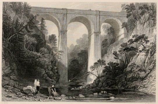
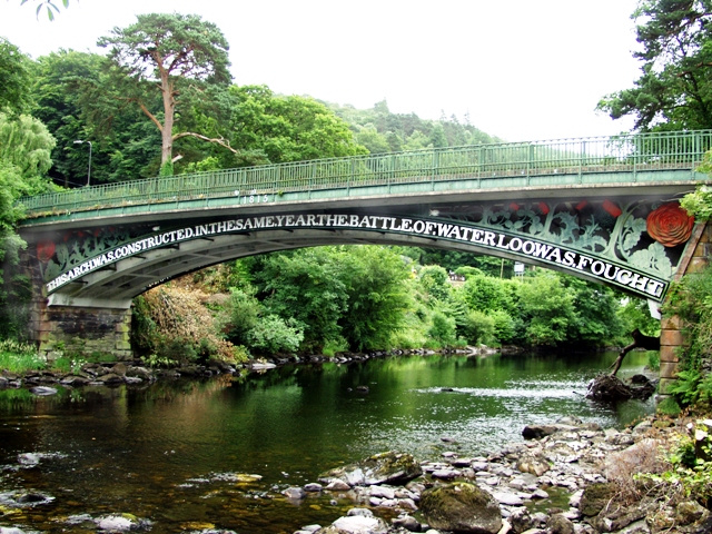
iron; that at Bettws-y-Coed, over the Conway—called the Waterloo
Bridge, constructed in 1815—being a very fine specimen of Telford's
iron bridge-work.
|
Betws-y-Coed
iron bridge;
the famous Waterloo Bridge. [p.321]
© Copyright
Ray
Jones
and licensed for reuse under this
Creative Commons Licence.
|
Those parts of the road which had been the most dangerous
were taken in hand first, and, by the year 1819, the route had been
rendered comparatively commodious and safe. Angles were cut
off, the sides of hills were blasted away, and several heavy
embankments run out across formidable arms of the sea. Thus,
at Stanley Sands, near Holyhead, an embankment was formed 1300 yards
long and 16 feet high, with a width of 34 feet at the top, along
which the road was laid. Its breadth at the base was 114 feet,
and both sides were coated with rubble stones, as a protection
against storms. By the adoption of this expedient, a mile and
a half was saved in a distance of six miles. Heavy embankments
were also run out, where bridges were thrown across chasms and
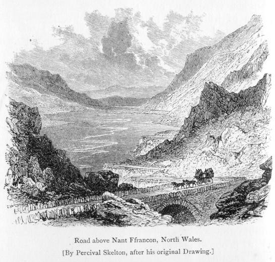
ravines, to maintain the general level. From Ty-Gwynn to Lake
Ogwen, the road along the face of the rugged hill and across the
river Ogwen was entirely new made, of a uniform width of 28 feet
between the parapets, with an inclination of only 1 in 22 in the
steepest place. A bridge was thrown over the deep chasm
forming the channel of the Ogwen, the embankment being carried
forward from the rock cutting, protected by high breastworks.
From Capel-Curig to near the great waterfall over the river Lugwy,
about a mile of new road was cut; and a still greater length from
Bettws across the river Conway and along the face of Dinas Hill to
Rhyddlanfair, a distance of 3 miles; its steepest descent being 1 in
22, diminishing to 1 in 45. By this improvement, the most
difficult and dangerous pass along the route through North Wales was
rendered safe and commodious. Another point of almost equal
difficulty occurred near Ty-Nant, through the rocky pass of Glynn
Duffrws, where the road was confined between steep rocks and rugged
precipices: there the way was widened and flattened by blasting, and
thus reduced to the general level; and so on eastward to Llangollen
and Chirk, where the main Shrewsbury road to London was joined. [p.323]
By means of these admirable roads the traffic of North Wales
continues to be mainly carried on to this day. Although
railways have superseded coach-roads in the more level districts,
the hilly nature of Wales precludes their formation in that quarter
to any considerable extent; and even in the event of railways being
constructed, a large part of the traffic of every country must
necessarily continue to pass over the old high roads. Without
them even railways would be of comparatively little value; for a
railway station is of use chiefly because of its easy accessibility,
and thus, both for passengers and merchandise, the common roads of
the country are as useful as ever they were, though the main
post-roads have in a great measure ceased to be employed for the
purposes for which they were originally designed.
The excellence of the roads constructed by Mr. Telford
through the formerly inaccessible counties of North Wales was the
theme of general praise; and their superiority, compared with those
of the richer and more level districts in the midland and western
English counties, becoming the subject of public comment, he was
called upon to execute like improvements upon that part of the
post-road which extended between Shrewsbury and the metropolis.
A careful survey was made of the several routes from London
northward by Shrewsbury as far as Liverpool; and the short line by
Coventry, being 153 miles from London to Shrewsbury, was selected as
the one to be improved to the utmost.
Down to 1819, the road between London and Coventry was in a
very bad state, being so laid as to become a heavy slough in wet
weather. There were many steep hills which required to be cut
down, in some parts of deep clay, in others of deep sand. A
mail-coach had been tried to Banbury; but the road below Aylesbury
was so bad, that the Post-Office authorities were obliged to give it
up. The twelve miles from Towcester to Daventry were still
worse. The line of way was covered with banks of dirt; in
winter it was a puddle of from four to six inches deep quite as bad
as it had been in Arthur Young's time; and when horses passed along
the road, they came out of it a mass of mud and mire. [p.325]
There were also several steep and dangerous hills to be crossed; and
the loss of horses by fatigue in travelling by that route at the
time was very great.
Even the roads in the immediate neighbourhood of the
metropolis were little better, those under the Highgate and
Hampstead trust being pronounced in a wretched state. They
were badly formed, on a clay bottom, and being undrained, were
almost always wet and sloppy. The gravel was usually tumbled
on and spread unbroken, so that the materials, instead of becoming
consolidated, were only rolled about by the wheels of the carriages
passing over them.
Mr. Telford applied the same methods in the reconstruction of
these roads that he had already adopted in Scotland and Wales, and
the same improvement was shortly felt in the more easy passage over
them of vehicles of all sorts, and in the great acceleration of the
mail service. At the same time, the line along the coast from
Bangor, by Conway, Abergele, St. Asaph, and Holywell, to Chester,
was greatly improved. As forming the mail road from Dublin to
Liverpool, it was considered of importance to render it as safe and
level as possible. The principal new cuts on this line were
those along the rugged skirts of the huge Penmaen-Mawr; around the
base of Penmaen-Bach to the town of Conway; and between St. Asaph
and Holywell, to ease the ascent of Rhyall Hill.
But more important than all, as a means of completing the
main line of communication between England and Ireland, there were
the great bridges over the Conway and the Menai Straits to be
constructed. The dangerous ferries at those places had still
to be crossed in open boats, sometimes in the night, when the
luggage and mails were exposed to great risks. Sometimes,
indeed, they were wholly lost, and passengers were lost with them.
It was therefore determined, after long consideration, to erect
bridges over these formidable straits, and Mr. Telford was employed
to execute the works,—in what manner, we propose to describe in the
next chapter.
――――♦―――
CHAPTER XII.
THE MENAI AND CONWAY BRIDGES.
|
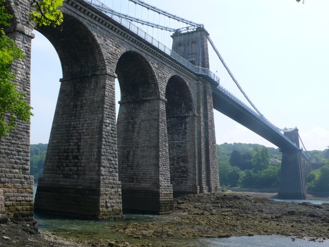
Menai
Suspension Bridge;
view along the bridge from the Anglesey side at low tide.
© Copyright
Nigel
Mykura and licensed for reuse under this
Creative Commons Licence.
|
SO long as the
dangerous Straits of Menai had to be crossed in an open ferry-boat,
the communication between London and Holyhead was necessarily
considered incomplete. While the roads through North Wales
were so dangerous as to deter travellers between England and Ireland
from using that route, the completion of the remaining link of
communication across the Straits was of comparatively little
importance. But when those roads had, by the application of
much capital, skill, and labour, been rendered so safe and
convenient that the mail and stage coaches could run over them at
the rate of from eight to ten miles an hour, the bridging of the
Straits became a measure of urgent public necessity. The increased
traffic by this route so much increased the quantity of passengers
and luggage, that the open boats were often dangerously overloaded;
and serious accidents, attended with loss of life and property, came
to be of frequent occurrence.
The erection of a bridge over the Straits had long been matter of
speculation amongst engineers. As early as 1776, Mr. Colborne
proposed his plan of an embankment with a bridge in the middle of
it; and a few years later, in 1785, Mr. Nichols proposed a wooden
viaduct, furnished with drawbridges at Cadnant Island. Later still,
Mr. Rennie proposed his design of a cast iron bridge. But none of
these plans were carried out, and the whole subject remained in
abeyance until the year 1810, when a commission was appointed to
inquire and report as to the state of the roads between Shrewsbury,
Chester, and Holyhead. The result was, that Mr. Telford was called
upon to report as to the most effectual method of bridging the Menai
Strait, and thus completing the communication with the port of
embarkation for Ireland.
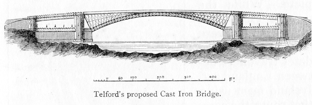
Mr. Telford submitted alternative plans for a bridge over the
Strait: one at the Swilly Rock, consisting of three cast iron arches
of 260 feet span, with a stone arch of 100 feet span between each
two iron ones, to resist their lateral thrust; and another at
Ynys-y-moch, to which he himself attached the preference, consisting
of a single cast iron arch of 500 feet span, the crown of the arch
to be 100 feet above high water of spring tides, and the breadth of
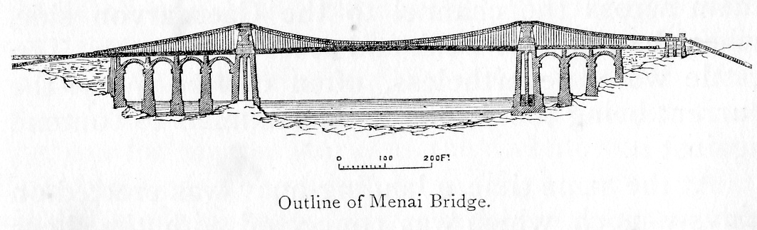
the roadway to be 40 feet.
|
|
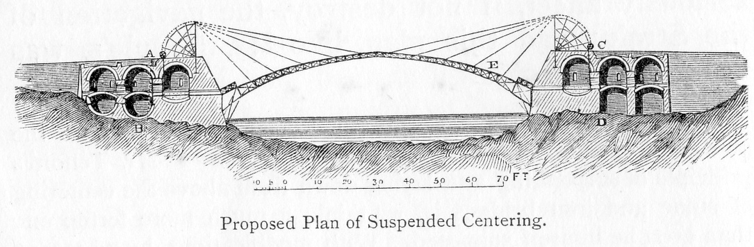
The principal objection taken to this plan by engineers generally,
was the supposed difficulty of erecting a proper centering to
support the arch during construction; and the mode by which Mr.
Telford proposed to overcome this may be cited in illustration of
his ready ingenuity in overcoming difficulties. He proposed to
suspend the centering from above instead of supporting it from below
in the usual manner—a contrivance afterwards revived by another very
skilful engineer, the late Mr. Brunel. Frames, 50 feet high, were to
be erected on the top of the abutments, and on these, strong blocks,
or rollers and chains, were to be fixed, by means of which, and by
the aid of windlasses and other mechanical powers, each separate
piece of centering was to be raised into, and suspended in, its
proper place. Mr. Telford regarded this method of constructing
centres as applicable to stone as well as to iron arches; and indeed
it is applicable, as Mr. Brunel held, to the building of the arch
itself. [p.330] Mr. Telford
anticipated that, if the method recommended by him were successfully
adopted on the large scale proposed at Menai, all difficulties with
regard to carrying bridges over deep ravines would be done away
with, and a new era in bridge-building begun. For this and other
reasons—but chiefly because of the much greater durability of a cast
iron bridge compared with the suspension bridge afterwards adopted—it is matter of regret that he was not permitted to carry out this
novel and grand design. It was, however, again objected by mariners
that the bridge would seriously affect, if not destroy, the
navigation of the Strait; and this plan, like Mr. Rennie's, was
eventually rejected. |
|
Several years passed, and during the interval Mr. Telford was
consulted as to the construction of a bridge over Runcorn Gap on the
Mersey, above Liverpool. As the river was there about 1200 feet
wide, and much used for purposes of navigation, a bridge of the
ordinary construction was found inapplicable. But as he was required
to furnish a plan of the most suitable structure, he proceeded to
consider how the difficulties of the case were to be met. The only
practicable plan, he thought, was a bridge constructed on the
principle of suspension. Expedients of this kind had long been
employed in India and America, where wide rivers were crossed by
means of bridges formed of ropes and chains; and even in this
country a suspension bridge, though of a very rude kind, had long
been in use near Middleton on the Tees, where, by means of two
common chains stretched across the river, upon which a footway of
boards was laid, the colliers were enabled to pass from their
cottages to the colliery on the opposite bank.
Captain (afterwards Sir Samuel) Brown took out a patent for forming
suspension bridges in 1817; but it appears that Telford's attention
had been directed to the subject before this time, as he was first
consulted respecting the Runcorn Bridge in the year 1814, when he
proceeded to make an elaborate series of experiments on the tenacity
of wrought iron bars, with the object of employing this material in
his proposed structure. After he had made upwards of two hundred
tests of malleable iron of various qualities, he proceeded to
prepare his design of a bridge, which consisted of a central opening
of 1000 feet span, and two side openings of 500 feet each, supported
by pyramids of masonry placed near the low-water lines. The roadway
was to be 30 feet wide, divided into one central footway and two
distinct carriageways of 12 feet each. At the same time he prepared
and submitted a model of the central opening, which satisfactorily
stood the various strains which were applied to it. This Runcorn
design of 1814 was of a very magnificent character, perhaps superior
even to that of the Menai Suspension Bridge, afterwards erected; but
unhappily the means were not forthcoming to carry it into effect.
The publication of his plan and report had, however, the effect of
directing public attention to the construction of bridges on the
suspension principle; and many were shortly after designed and
erected by Telford and other engineers in different parts of the
kingdom. |
|
Mr. Telford continued to be consulted by the Commissioners of the
Holyhead Roads as to the completion of the last and most important
link in the line of communication between London and Holyhead, by
bridging the and at one of their meetings in 1815, shortly after the
publication of his Runcorn design, the inquiry was made whether a
bridge upon the same principle was not applicable in this particular
case. The engineer was instructed again to examine the Straits and
submit a suitable plan and estimate, which he proceeded to do in the
early part of 1818. The site selected by him as the most favourable
was that which had been previously fixed upon for the projected cast
iron bridge, namely at Ynys-y-moch—the shores there being bold and
rocky, affording easy access and excellent foundations, while by
spanning the entire channel between the low-water lines, and the
roadway being kept uniformly 100 feet above the highest water at
spring tide, the whole of the navigable waterway would be left
entirely uninterrupted. The distance between the centres of the
supporting pyramids was proposed to be of the then unprecedented
width of 550 feet, and the height of the pyramids 53 feet above the
level of the roadway. The main chains were to be sixteen in number,
with a deflection of 37 feet, each composed of thirty-six bars of
half-inch-square iron, so placed as to give a square of six on each
side, making the whole chain about four inches in diameter, welded
together for their whole length, secured by bucklings, and braced
round with iron wire; while the ends of these great chains were to
be secured by a mass of masonry built over stone arches between each
end of the supporting piers and the adjoining shore. Four of the
arches were to be on the Anglesea, and three on the Caernarvonshire
side, each of them of 52 feet 6 inches span. The roadway was to be
divided, as in the Runcorn design—with a carriageway 12 feet wide on
each side, and a footpath of 4 feet in the middle. Mr. Telford's
plan was supported by Mr. Rennie and other engineers of eminence;
and the Select Committee of the House of Commons, being satisfied as
to its practicability, recommended Parliament to pass a Bill and to
make a grant of money to enable the work to be carried into effect.
The necessary Act passed in the session of 1818, and Mr. Telford
immediately proceeded to Bangor to make preparations for beginning
the works. The first proceeding was to blast off the inequalities of
the surface of the rock called Ynys-y-moch, situated on the western
or Holyhead side of the Strait, at that time accessible only at low
water. The object was to form an even surface upon it for the
foundation of the west main pier. It used to be at this point, where
the Strait was narrowest, that horned cattle were driven down,
preparatory to swimming them across the channel to the Caernarvon
side, when the tide was weak and at its lowest ebb. The cattle were,
nevertheless, often carried away, the current being too strong for
the animals to contend against it.
At the same time, a landing-quay was erected on Ynys-y-moch, which
was connected with the shore by an embankment carrying lines of
railway. Along these, horses drew the sledges laden with stone
required for the work; the material being brought in barges from
the quarries opened at Penmon Point, on the north-eastern extremity
of the Isle of Anglesea, a little to the westward of the northern
opening of the Strait. When the surface of the rock had been
levelled and the causeway completed, the first stone of the main
pier was laid by Mr. W. A. Provis, the resident engineer, on the
l0th of August, 1819; but not the slightest ceremony was observed on
the occasion.
Later in the autumn, preparations were made for proceeding with the
foundations of the eastern main pier on the Bangor side of the
Strait. After excavating the beach to a depth of 7 feet, a solid
mass of rock was reached, which served the purpose of an immoveable
foundation for the pier. At the same time, workshops were erected;
builders, artisans, and labourers were brought together from distant
quarters; vessels and barges were purchased or built for the special
purpose of the work; a quay was constructed at Penmon Point for
loading the stones for the piers; and all the requisite preliminary
arrangements were made for proceeding with the building operations
in the ensuing spring.
A careful specification of the masonry work was drawn up, and the
contract was let to Messrs. Stapleton and Hall; but as they did not
proceed satisfactorily, and desired to be released from the
contract, it was relet on the same terms to Mr. John Wilson, one of
Mr. Telford's principal contractors for mason work on the Caledonian
Canal. The building operations were begun with great vigour early in
1820. The three arches on the Caernarvonshire side and the four on
the Angle-sea side were first proceeded with. They are of immense
magnitude, and occupied four years in construction, having been
finished late in the autumn of 1824. These piers are 65 feet in
height from high-water line to the springing of the arches, the span
of each being 52 feet 6 inches. The work of the main piers also made
satisfactory progress, and the masonry proceeded so rapidly that
stones could scarcely be got from the quarries in sufficient
quantity to keep the builders at work. By the end of June about
three hundred men were employed.
The two principal piers, each 153 feet in height, upon which the
main chains of the bridge were to be suspended, were built with
great care and under rigorous inspection. In these, as indeed in
most of the masonry of the bridge, Mr. Telford adopted the same
practice which he had employed in his previous bridge structures,
that of leaving large void spaces, commencing above high water mark
and continuing them up perpendicularly nearly to the level of the
roadway. "I have elsewhere expressed my conviction," he says, when
referring to the mode of constructing these piers, "that one of the
most important improvements which I have been able to introduce into
masonry consists in the preference of cross-walls to rubble, in the
structure of a pier, or any other edifice requiring strength. Every
stone and joint in such walls is open to inspection in the progress
of the work, and even afterwards, if necessary; but a solid filling
of rubble conceals itself, and may be little better than a heap of
rubbish confined by side walls." The walls of these main piers were
built from within as well as from without all the way up, and the
inside was as carefully and closely cemented with mortar as the
external face. Thus the whole pier was bound firmly together, and
the utmost strength given, while the weight of the superstructure
upon the lower parts of the work was reduced to a minimum.
Over the main piers, the small arches intended for the roadways were
constructed, each being 15 feet to the springing of the arch, and 9
feet wide. Upon these arches the masonry was carried upwards, in a
tapering form, to a height of 53 feet above the level of the road. As these piers were to carry the immense weight of the suspension
chains, great pains were taken with their construction, and all the
stones, from top to bottom, were firmly bound together with iron
dowels to prevent the possibility of their being separated or bulged
by the immense pressure they had to withstand.
The most important point in the execution of the details of the
bridge, where the engineer had no past experience to guide him, was
in the designing and fixing of the wrought iron work. Mr. Telford
had continued his experiments as to the tenacity of bar iron, until
he had obtained several hundred distinct tests; and at length, after
the most mature deliberation, the patterns and dimensions were
finally arranged by him, and the contract for the manufacture of the
whole was let to Mr. Hazeldean, of Shrewsbury, in the year 1820. The
iron was to be of the best Shropshire, drawn at Upton forge, and
finished and proved at the works, under the inspection of a person
appointed by the engineer.
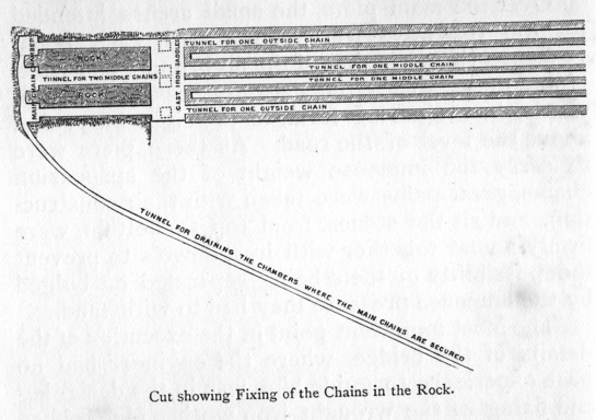
The mode by which the land ends of these enormous suspension chains
were rooted to the solid ground on either side of the Strait, was
remarkably ingenious and effective. Three oblique tunnels were made
by blasting the rock on the Anglesea side; they were each about six
feet in diameter, the excavations being carried down an inclined
plane to the depth of about twenty yards. A considerable width of
rock lay between each tunnel, but at the bottom they were all united
by a connecting horizontal avenue or cavern, sufficiently capacious
to enable the workmen to fix the strong iron frames, composed
principally of thick flat cast iron plates, which were engrafted
deeply into the rock, and strongly bound together by the iron work
passing along the horizontal avenue; so that, if the iron held, the
chains could only yield by tearing up the whole mass of solid rock
under which they were thus firmly bound.
A similar method of anchoring the main chains was adopted on the
Caernarvonshire side. A thick bank of earth had there to be cut
through, and a solid mass of masonry built in its place, the rock
being situated at a greater distance from the main pier; involving a
greater length of suspending chain, and a disproportion in the
catenary or chord line on that side of the bridge. The excavation
and masonry thereby rendered necessary proved a work of vast labour,
and its execution occupied a considerable time; but by the beginning
of the year 1825 the suspension pyramids, the land piers and arches,
and the rock tunnels, had all been completed, and the main chains
were firmly secured in them; the work being sufficiently advanced to
enable the suspending of the chains to be proceeded with. This was
by far the most difficult and anxious part of the undertaking.
With the same careful forethought and provision for every
contingency which had distinguished the engineer's procedure in the
course of the work, he had made frequent experiments to ascertain
the actual power which would be required to raise the main chains to
their proper curvature. A valley lay convenient for the purpose, a
little to the west of the bridge on the Anglesea side. Fifty-seven
of the intended vertical suspending rods, each nearly ten feet long
and an inch square, having been fastened together, a piece of chain
was attached to one end to make the chord line 570 feet in length;
and experiments having been made and comparisons drawn, Mr. Telford
ascertained that the absolute weight of one of the main chains of
the bridge between the points of suspension was 23½ tons, requiring
a strain of 39½ tons to raise it to its proper curvature. On this
calculation the necessary apparatus required for the hoisting was
prepared. The mode of action finally determined on for lifting the
main chains, and fixing them into their places, was to build the
central portion of each upon a raft 450 feet long and 6 feet wide,
then to float it to the site of the bridge, and lift it into its
place by capstans and proper tackle.
At length all was ready for hoisting the first great chain, and
about the middle of April, 1825, Mr. Telford left London for Bangor
to superintend the operations. An immense assemblage collected to
witness the sight; greater in number than any that had been
collected in the same place since the men of Anglesea, in their
war-paint, rushing down to the beach, had shrieked defiance across
the Straits at their Roman invaders on the Caernarvon shore.
Numerous boats arrayed in gay colours glided along the waters; the
day—the 26th of April—being bright, calm, and in every way
propitious.
At half-past two, about an hour before high water, the raft bearing
the main chain was cast off from near Treborth Mill, on the
Caernarvon side. Towed by four boats, it began gradually to move
from the shore, and with the assistance of the tide, which caught it
at its further end, it swung slowly and majestically round to its
position between the main piers, where it was moored. One end of the
chain was then bolted to that which hung down the face of the
Caernarvon pier; whilst the other was attached to ropes connected
with strong capstans fixed on the Anglesea side, the ropes passing
by means of blocks over the top of the pyramid of the Anglesea pier.
The capstans for hauling in the ropes bearing the main chain, were
two in number, manned by about 150 labourers. When all was ready,
the signal was given to "Go along!" A band of fifers struck up a
lively tune; the capstans were instantly in motion, and the men
stepped round in a steady trot. All went well. The ropes gradually
coiled in. As the strain increased, the pace slackened a little; but
"Heave away, now she comes!" was sung out. Round went the men, and
steadily and safely rose the ponderous chain. |
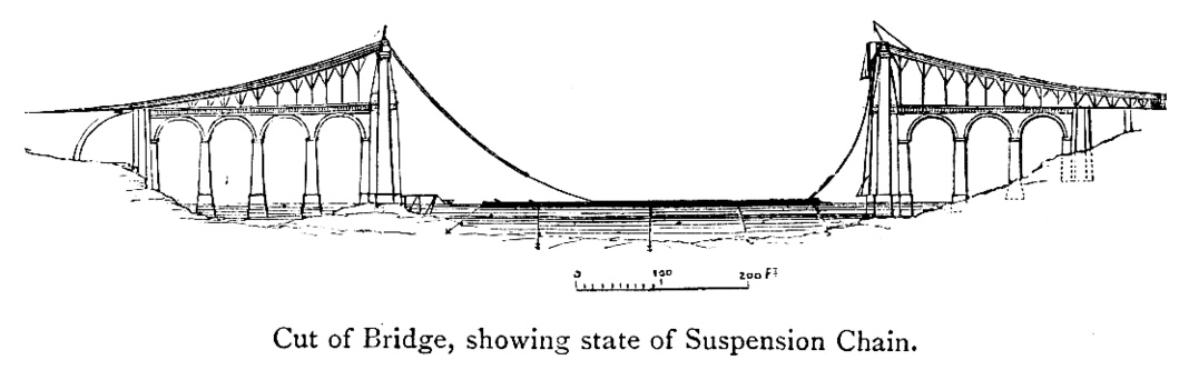
|
The tide had by this time turned, and bearing upon the side of the
raft, now getting freer of its load, the current floated it away
from under the middle of the chain still resting on it, and it swung
easily off into the water. Until this moment a breathless silence
pervaded the watching multitude; and nothing was heard among the
working party on the Anglesea side but the steady tramp of the men
at the capstans, the shrill music of the fife, and the occasional
order to "Hold on!" or "Go along!" But no sooner was the raft seen
floating away, and the great chain safely swinging in the air, than
a tremendous cheer burst forth along both sides of the Straits.
The rest of the work was only a matter of time. The most anxious
moment had passed. In an hour and thirty-five minutes after the
commencement of the hoisting, the chain was raised to its proper
curvature, and fastened to the land portion of it which had been
previously placed over the top of the Anglesea pyramid. Mr. Telford
ascended to the point of fastening, and satisfied himself that a
continuous and safe connection had been formed from the Caernarvon
fastening on the rock to that on Anglesea.
The announcement of the fact was followed by loud and prolonged
cheering from the workmen, echoed by the spectators, and extending
along the Straits on both sides, until it seemed to die away along
the shores in the distance. Three foolhardy workmen, excited by the
day's proceedings, had the temerity to scramble along the upper
surface of the chain—which was only nine inches wide and formed a
curvature of 590 feet—from one side of the Strait to the other! [p.342]
Far different were the feelings of the engineer who had planned this
magnificent work. Its failure had been predicted; and, like Brindley's Barton Viaduct, it had been freely spoken of as a "castle
in the air." Telford had, it is true, most carefully tested every
part by repeated experiment, and so conclusively proved the
sufficiency of the iron chains to bear the immense weight they would
have to support, that he was thoroughly convinced as to the
soundness of his principles of construction, and satisfied that, if
rightly manufactured and properly put together, the chains would
hold, and that the piers would sustain them. Still there was
necessarily an element of uncertainty in the undertaking. It was the
largest structure of the kind that had ever been attempted. There
was the contingency of a flaw in the iron; some possible stamping in
the manufacture; some little point which, in the multiplicity of
details to be attended to, he might have overlooked, or which his
subordinates might have neglected. It was, indeed, impossible but
that he should feel intensely anxious as to the result of the day's
operations. Mr. Telford afterwards stated to a friend, only a few
months before his death, that for some time previous to the opening
of the bridge, his anxiety was so great that he could scarcely
sleep; and that a continuance of that condition must have very soon
completely undermined his health. We are not, therefore, surprised
to learn that when his friends rushed to congratulate him on the
result of the first day's experiment, which decisively proved the
strength and solidity of the bridge, they should have found the
engineer on his knees engaged in prayer. A vast load had been taken
off his mind; the perilous enterprise of the day had been
accomplished without loss of life; and his spontaneous act was
thankfulness and gratitude. |
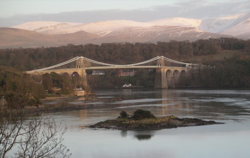
|
Modelled on Telford's abortive Runcorn Suspension
Bridge across the Mersey, the Menai Suspension Bridge is seen here
from the Anglesey bank across the notorious 'Swellies', and from a point near to
Robert Stephenson's Britannia Bridge. The Menai Bridge's decking and
suspension members have been rebuilt substantially over the years
(e.g. compare bearing rods with those in Percival Skelton's illustration below) to address
wear and to cater for an increasing traffic load, since relieved by
the brilliant rebuilding of Stephenson's bridge.
Picture Wikipedia. |
|
The suspension of the remaining fifteen chains was accomplished
without difficulty. The last was raised and fixed on the 9th of
July, 1825, when the entire line was completed. On fixing a final
bolt, a band of music descended from the top of the suspension pier
on the Anglesea side to a scaffolding erected over the centre of the
curved part of the chains, and played the National Anthem amidst the
cheering of many thousand persons assembled along the shores of the
Strait: while the workmen marched in procession along the bridge, on
which a temporary platform had been laid, and the 'St. David'
steam-packet of Chester passed under the chains towards the Smithy
Rocks and back again, thus re-opening the navigation of the Strait.
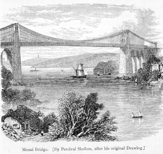
In August the road platform was commenced, and in September the
trussed bearing bars were all suspended. The road was constructed of
timber in a substantial manner, the planking being spiked together,
with layers of patent felt between the planks, and the carriage way
being protected by oak guards placed seven feet and a half apart. Side railings were added; the toll-houses and approach-roads were
completed by the end of the year; and the bridge was opened for
public traffic on Monday, the 30th of January, 1826, when the London
and Holyhead mail coach passed over it for the first time, followed
by the Commissioners of the Holyhead roads, the engineer, several
stagecoaches, and a multitude of private persons too numerous to
mention.
We may briefly add a few facts as to the quantities of materials
used, and the dimensions of this remarkable structure. The total
weight of iron was 2,187 tons, in 33,265 pieces. The total length of
the bridge is 1,710 feet, or nearly a third of a mile; the distance
between the points of suspension of the main bridge being 579 feet. The total sum expended by Government in its erection, including the
embankment and about half a mile of new line of road on the
Caernarvon side, together with the toll-houses, was £120,000. |
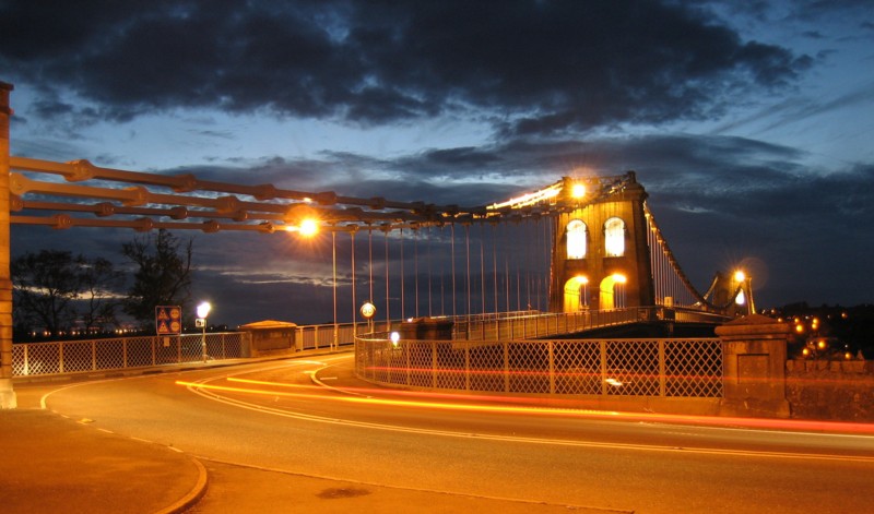
Menai Suspension Bridge in the evening. Picture Wikipedia.
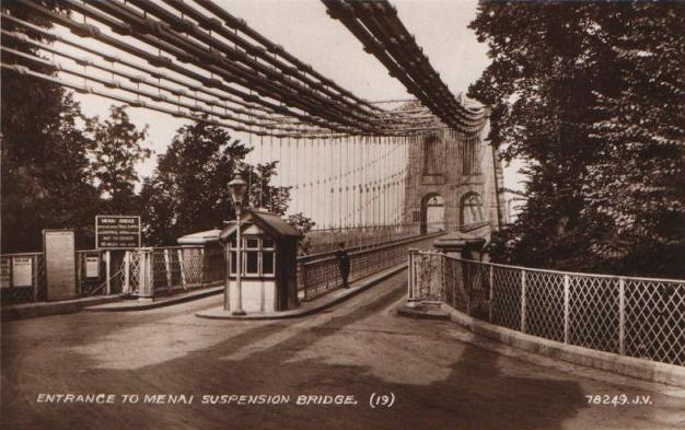
Postcard showing an earlier view.
As built, the Bridge had three main suspensions chains.
|
Notwithstanding the wonders of the Britannia Bridge subsequently
erected by Robert Stephenson for the passage across the same strait
of the Chester and Holyhead Railway, the Menai Bridge of Telford is
by far the most picturesque object. "Seen as I approached it," says
Mr. Roscoe, "in the clear light of an autumnal sunset, which threw
an autumnal splendour on the wide range of hills beyond, and the
sweep of richly variegated groves and plantations which covered
their base—the bright sun, the rocky picturesque foreground, villas,
spires, and towers here and there enlivening the prospect—the Menai
Bridge appeared more like the work of some great magician than the
mere result of man's skill and industry,"

Shortly after the Menai Bridge was begun, it was determined by the
Commissioners of the Holyhead road that a bridge of similar design
should be built over the estuary of the Conway, immediately opposite
the old castle at that place, and which had formerly been crossed by
an open ferry boat. The first stone was laid on the 3rd of April,
1822, and the works having proceeded satisfactorily, the bridge and
embankment approaching it were completed by the summer of 1826. But
the operations being of the same kind as those connected with the
larger structure above described, though of a much less difficult
character, it is unnecessary to enter into any details as to the
several stages of its construction. In this bridge the width between
the centres of the supporting towers is 327 feet, and the height of
the under side of the roadway above high water of spring tides only
15 feet. The heaviest work was an embankment as its eastern
approach, 2,015 feet in length and about 300 feet in width at its
highest part.
It will be seen, from the view of the bridge given on the opposite
page, that it is a highly picturesque structure, and combines, with
the estuary which it crosses, and the ancient castle of Conway, in
forming a landscape that is rarely equalled. |
――――♦――――
[Next Page] |